Location
Latitude: |
38-35-59.9945S (-38.599998) |
Longitude: |
142-55-01.2268E (142.917007) |
Magnetic Variation: |
11.2 E (as of April 2024 from WMM2020 model) |
Time Zone: |
UTC +10.0 (Standard Time) UTC +11.0 (Daylight Savings Time) |
Contacts
Manager: |
: |
Operations
Airport Status: |
Operational |
Facility Use: |
Public |
Type: |
Airport |
Traffic Pattern Altitude (MSL): |
1000 feet (305 m) |
Based Aircraft
Annual Operations (as of )
Communications
| CTAF: | 127.1 |
| MISC: | 113.4 |
| MISC: | 119.6 |
Fixed Based Operators (FBOs) & Fuel
(Click on a business for detail)
Please help us keep this information up to date. This is a FREE SERVICE just like everything else on Airport Guide! If you see that a business needs to be added, modified, or deleted please fill out our Update Form.
To add, modify, or delete a business click here.
Please help us keep this information up to date. This is a FREE SERVICE just like everything else on Airport Guide! If you see that a business needs to be added, modified, or deleted please fill out our Update Form.
| Business Name | Frequency | Phone | Fuel Grade |
|---|
Flight Service Stations
| Primary | Alternate | |
| FSS on Field: | ||
| FSS Name (ID): | ||
| Frequency: | ||
| Toll Free Phone: |
Instrument Procedures / Charts
Terminal Procedures are only available for airports in several countries with more being added all the time. If you are looking for a specific country's charts, please send an email to support(at)airportguide.com stating the country name. This will be used to prioritize the implementation.
Navigation Aids (Navaids) near YPBH
| Dist (NM) | ID | Morse Code | Name | Type | Freq | True Hdg | Mag Hdg |
|---|---|---|---|---|---|---|---|
| 28.7 | WBL | Warrnambool | NDB | 395 | 310 | 299 | |
| 65.0 | YWE | Yarrowee | NDB | 389 | 37 | 26 | |
| 65.1 | YWE | Yarrowee | VOR | 114.30 | 37 | 26 | |
| 70.0 | POD | Portland | NDB | 212 | 283 | 272 | |
| 70.0 | HML | Hamilton | NDB | 203 | 324 | 313 | |
| 77.2 | BLT | Ballarat | NDB | 239 | 32 | 21 | |
| 79.8 | AV | Avalon | VOR-DME | 116.10 | 65 | 54 | |
| 81.1 | AV | Avalon | NDB | 404 | 64 | 53 | |
| 85.5 | RPY | Ripley (Decommissioned) | NDB | 224 | 60 | 49 | |
| 89.2 | KII | King Island | NDB | 332 | 150 | 138 | |
| 95.6 | PCK | Point Cook | NDB | 419 | 65 | 54 |
Nearby Airports with Fuel
| Dist (NM) | Name (Airport IDs) | True Hdg | Mag Hdg | Fuel Grade |
|---|
Notices to Airmen (NOTAMS)
Remarks
No remarks for this landing facility
Runways
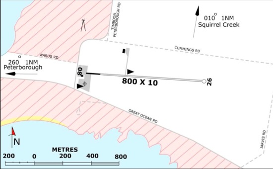
Runway Summary
| Runways: | 09/27 18/36 |
| Longest Runway: | 09/27 is 3608 ft (1100 m) long |
| Runways with an Instrument Approach: |
YPBH Airport Runway Details
| Runway 09/27 | 3608 ft x ft (1100 m x 0 m) | |
Runway 09 |
Runway 27 |
|
Glide Path Angle: |
0.0 degrees | 0.0 degrees |
| Runway 18/36 | 2099 ft x ft (640 m x 0 m) | |
Runway 18 |
Runway 36 |
|
Glide Path Angle: |
0.0 degrees | 0.0 degrees |
Services
Maps & Diagrams
YPBH Sectional
Flight Planning
at skyvector.com
at skyvector.com