Location
Latitude: |
42-06-24.9700N (42.106936) |
Longitude: |
111-54-45.2550W (-111.912571) |
Elevation: |
4727.8 feet MSL (1441 m MSL) |
Magnetic Variation: |
11.1 E (as of April 2024 from WMM2020 model) |
Time Zone: |
UTC -7.0 (Standard Time) UTC -6.0 (Daylight Savings Time) |
From City: |
02 N.M. NW of Preston, Idaho |
Found On: |
Salt Lake City Chart |
FAA Region: |
ANM |
Contacts
Manager: |
Publicly owned: |
| CRAIG BIGGS 1319 W 800 NORTH PRESTON, ID 83263 208-852-2151 |
CITY OF PRESTON & FRANKLIN CO 70 WEST ONEIDA PRESTON, ID 83263 208-852-1817 |
Operations
Airport Status: |
Operational |
Facility Use: |
Public |
Type: |
Airport |
Activation Date: |
04/1940 |
Control tower: |
No |
Attendance (Months/Days/Hours): |
Months/Days/Hours ALL/ALL/DALGT |
Boundary ARTCC: |
ZLC (Salt Lake City) |
Responsible ARTCC: |
ZLC (Salt Lake City) |
Lighting Schedule: |
SEE RMK |
Segmented Circle Indicator: |
Yes |
Traffic Pattern Altitude (MSL): |
5728 feet (1746 m) |
NOTAMs Facility: |
BOI |
NOTAM-D Service: |
Yes |
International Airport of Entry: |
No |
Customs Landing Rights: |
No |
Military Landing Rights: |
No |
Civil/Military Joint Use: |
No |
Based Aircraft
| Single Engine: | 29 |
| GA Helicopters: | 1 |
Annual Operations (as of 05/30/2023)
| Total Operations: | 7040 | |
| GA Local: | 2000 | 28.4% |
| GA Itinerant: | 5000 | 71.0% |
| Military Aircraft: | 40 | 0.6% |
Communications
| CTAF: | 122.800 |
| Unicom: | 122.800 |
Fixed Based Operators (FBOs) & Fuel
(Click on a business for detail)
Please help us keep this information up to date. This is a FREE SERVICE just like everything else on Airport Guide! If you see that a business needs to be added, modified, or deleted please fill out our Update Form.
To add, modify, or delete a business click here.
Please help us keep this information up to date. This is a FREE SERVICE just like everything else on Airport Guide! If you see that a business needs to be added, modified, or deleted please fill out our Update Form.
Area Code: 208 |
| Business Name | Frequency | Phone | Fuel Grade |
|---|---|---|---|
| Preston Flying Service
Update FBO info |
Unicom 122.8 | 852-2151 |
Flight Service Stations
| Primary | Alternate | |
| FSS on Field: | N | |
| FSS Name (ID): | Boise(BOI) | |
| Frequency: | ||
| Toll Free Phone: | 1-800-WX-BRIEF |
Instrument Procedures / Charts
Terminal Procedures are only available for airports in several countries with more being added all the time. If you are looking for a specific country's charts, please send an email to support(at)airportguide.com stating the country name. This will be used to prioritize the implementation.
Navigation Aids (Navaids) near U10
| Dist (NM) | ID | Morse Code | Name | Type | Freq | True Hdg | Mag Hdg |
|---|---|---|---|---|---|---|---|
| 19.3 | LHO | . _ . . . . . . _ _ _ | Brigham City | VOR-DME | 112.90 | 192 | 181 |
| 24.6 | MLD | _ _ . _ . . _ . . | Malad City | VOR-DME | 117.40 | 283 | 272 |
| 36.2 | BMC | _ . . . _ _ _ . _ . | Brigham City | NDB | 294 | 191 | 180 |
| 53.6 | OGD | _ _ _ _ _ . _ . . | Ogden | VORTAC | 115.70 | 188 | 177 |
| 56.3 | PIH | . _ _ . . . . . . . | Pocatello | VOR-DME | 112.60 | 324 | 313 |
| 57.9 | PI | . _ _ . . . | Tyhee | NDB | 383 | 332 | 321 |
| 59.2 | HIF | . . . . . . . . _ . | Hill | TACAN | 111.20 | 182 | 171 |
| 63.3 | EVW | . . . . _ . _ _ | Evanston | VOR-DME | 109.60 | 141 | 130 |
| 75.5 | TCH | _ _ . _ . . . . . | Wasatch | VORTAC | 116.80 | 182 | 171 |
| 79.7 | FBR | . . _ . _ . . . . _ . | Fort Bridger | VOR-DME | 114.45 | 122 | 111 |
| 80.3 | SWU | . . . . _ _ . . _ | Sweden | NDB | 350 | 352 | 341 |
| 80.4 | SLC | . . . . _ . . _ . _ . | Salt Lake City | VOT | 111.00 | 181 | 170 |
| 84.8 | BPI | _ . . . . _ _ . . . | Big Piney | VOR-DME | 116.50 | 69 | 58 |
| 85.0 | IDA | . . _ . . . _ | Idaho Falls | VOR-DME | 113.85 | 355 | 344 |
| 89.5 | ID | . . _ . . | Uconn | NDB | 324 | 358 | 347 |
| 91.2 | BYI | _ . . . _ . _ _ . . | Burley | VOR-DME | 114.10 | 288 | 277 |
| 91.9 | TVY | _ . . . _ _ . _ _ | Tooele | NDB | 371 | 192 | 181 |
| 97.2 | LCU | . _ . . _ . _ . . . _ | Lucin | VORTAC | 113.60 | 243 | 232 |
Nearby Airports with Fuel
Notices to Airmen (NOTAMS)
Remarks
| A110-1 | LCTD ON PLATEAU. SHARP DROPOFF NEAR THR RWYS 04, 17 & 35. |
| A110-2 | RWY 17/35 CLSD WINTER. |
| A110-3 | FOR CD CTC SALT LAKE ARTCC AT 801-320-2568. |
| A12 | CITY OF PRESTON'S ADDRESS AND TEL NUMBER. |
| A33-17/35 | GRVL SFC USED BY CROP DUSTERS. |
| A43-22 | UNUSBL BYD 4.0 NM FM THR AND DOES NOT PRVD OBSTN CLNC. |
| A51-22 | DSPLCD THR MKD WITH DSPLCD THR BAR ONLY. |
| A57-22 | APCH SLOPE 31:1 TO DSPLCD THR. |
| A58-22 | +4' FENCE AT 100', 75' RIGHT. |
| A81-APT | ACTVT REIL RWY 04: MIRL RWY 04/22 - CTAF. PAPI RWY 04 & RWY 22 OPR CONSLY. |
| A83 | 3 WINDSOCKS (LGTD) & WIND TEE. |
| E111 | ESTABD PRIOR TO 15 MAY 1959. |
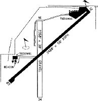
Runways
Runway Summary
| Runways: | 04/22 17/35 |
| Longest Runway: | 04/22 is 3557 ft (1084 m) long |
| Runways with an Instrument Approach: |
U10 Airport Runway Details
| Runway 04/22 | 3557 ft x 60 ft (1084 m x 18 m) | |
| Runway Length Source: | 3RD PARTY SURVEY as of 08/06/2019 | |
| Surface: | Asphalt - Good condition - No special surface treatment | |
| Runway Edge Lights: | Medium Intensity | |
Runway Weight Bearing Capacity (in thousands of pounds) |
||
| Single Wheel Landing Gear: | 12.0 | |
Runway 04 |
Runway 22 |
|
Elevation: |
4725.0 | 4724.1 |
Latitude: |
42-06-14.9186N | 42-06-38.3378N |
Longitude: |
111-55-01.2636W | 111-54-26.1030W |
|
Runway True Alignment: |
048 | 228 |
Glide Path Angle: |
3.0 degrees | 3.0 degrees |
Traffic Pattern: |
Left | Left |
Runway Markings Type: |
Basic | Basic |
Runway Markings Condition: |
Good | Good |
Object at End: |
ROAD | |
Object Height: |
17 | |
Distance from End: |
200 | |
Object Centerline Offset: |
70 ft. right of centerline | |
Visual Glide Slope Indicators: |
2-Light PAPI On Left Side Of Runway | 2-Light PAPI On Left Side Of Runway |
REIL: |
Yes | |
Threshold Crossing Height: |
44 | 44 |
Threshold Elevation: |
4724.3 | |
Displaced Threshold: |
384 | |
Threshold Latitude: |
42-06-35.8165N | |
Threshold Longitude: |
111-54-29.8865W |
| Runway 17/35 | 2375 ft x 30 ft (724 m x 9 m) | |
| Runway Length Source: | 3RD PARTY SURVEY as of 08/06/2019 | |
| Surface: | Asphalt - Good condition - No special surface treatment | |
Runway 17 |
Runway 35 |
|
Elevation: |
4727.7 | 4727.5 |
Latitude: |
42-06-34.2095N | 42-06-10.7602N |
Longitude: |
111-54-47.9806W | 111-54-47.2320W |
|
Runway True Alignment: |
179 | 359 |
Glide Path Angle: |
0.0 degrees | 0.0 degrees |
Traffic Pattern: |
Left | Left |
Runway Markings Condition: |
Fair | Fair |
Object Centerline Offset: |
70 ft. right of centerline |
Services
Airframe Repair: |
Major |
Powerplant Repair: |
Major |
Bottled Oxygen: |
Low Pressure |
Bulk Oxygen: |
High Pressure |
Fuel Available: |
100LL, Jet A |
Landing Fees: |
No |
Parking: |
Hangars and tiedowns available |
Maps & Diagrams
U10 Sectional
Flight Planning
at skyvector.com
at skyvector.com