Location
Latitude: |
37-57-13.7000N (37.953806) |
Longitude: |
107-54-31.5000W (-107.90875) |
Elevation: |
9069.7 feet MSL (2764 m MSL) |
Magnetic Variation: |
8.9 E (as of April 2024 from WMM2020 model) |
Time Zone: |
UTC -7.0 (Standard Time) UTC -6.0 (Daylight Savings Time) |
From City: |
05 N.M. W of Telluride, Colorado |
Found On: |
Denver Chart |
FAA Region: |
ANM |
Contacts
Manager: |
Publicly owned: |
| KENNETH E. MAENPA 1500 LAST DOLLAR RD. SUITE 1 TELLURIDE, CO 81435 (970) 728-8601 |
TELLURIDE REGIONAL ARPT AUTH 1500 LAST DALLAR RD. SUITE 1 TELLURIDE, CO 81435 970-728-8600 |
Operations
Airport Status: |
Operational |
Facility Use: |
Public |
Type: |
Airport |
Activation Date: |
03/1986 |
Control tower: |
No |
Attendance (Months/Days/Hours): |
Months/Days/Hours APR-OCT/ALL/0700-2100 |
Boundary ARTCC: |
ZDV (Denver) |
Responsible ARTCC: |
ZDV (Denver) |
Lighting Schedule: |
SEE RMK |
Segmented Circle Indicator: |
Yes |
Traffic Pattern Altitude (MSL): |
10070 feet (3069 m) |
NOTAMs Facility: |
TEX |
NOTAM-D Service: |
Yes |
Aircraft Rescue and Firefighting: |
Class I ARFF Index: B Air Carrier Service: Scheduled Certification Date: 10/1992 |
Based Aircraft
| Single Engine: | 18 |
| Multi Engine: | 3 |
| Jet Engine: | 4 |
| GA Helicopters: | 1 |
| Gliders: | 1 |
Annual Operations (as of 01/02/2017)
| Total Operations: | 9402 | |
| Commercial: | 32 | 0.3% |
| GA Itinerant: | 9370 | 99.7% |
Communications
| CTAF: | 123.000 |
| Unicom: | 123.000 |
| AWOS-3: | 118.325 (970-728-1534) |
- APCH/DEP CTL SVC PRVDD BY DENVER ARTCC (ZDV) ON FREQS 125.35/354.05 (ABAJO PEAK RCAG).
Fixed Based Operators (FBOs) & Fuel
(Click on a business for detail)
Please help us keep this information up to date. This is a FREE SERVICE just like everything else on Airport Guide! If you see that a business needs to be added, modified, or deleted please fill out our Update Form.
To add, modify, or delete a business click here.
Please help us keep this information up to date. This is a FREE SERVICE just like everything else on Airport Guide! If you see that a business needs to be added, modified, or deleted please fill out our Update Form.
Area Code: 970 |
| Business Name | Frequency | Phone | Fuel Grade |
|---|---|---|---|
| Telluride Airport Services
Update FBO info |
Unicom 123.0 | 728-5051 | 100LL, Jet A |
Flight Service Stations
| Primary | Alternate | |
| FSS on Field: | N | |
| FSS Name (ID): | Denver(DEN) | |
| Frequency: | ||
| Toll Free Phone: | 1-800-WX-BRIEF |
Instrument Procedures / Charts
FAA Terminal Procedures valid from 0901Z 03/21/24 to 0901Z 04/18/24.
There are various types of charts available for an airport. They are listed in the Page Type column. Here is a legend for those types:
APD - Airport Diagram
DP - Departure Procedure Charts
HOT - Hot Spots
IAP - Instrument Approach Procedure Charts
MIN - Minimums
STAR - Standard Terminal Arrival Charts
| Page Type | Page Name | Volume | Action Since Last Cycle |
|---|---|---|---|
| APD | AIRPORT DIAGRAM | SW-1 | |
| IAP | LOC RWY 09 | SW-1 | Changed |
| IAP | RNAV (GPS) Y RWY 09 | SW-1 | |
| IAP | RNAV (GPS) Z RWY 09 | SW-1 | |
| IAP | VOR/DME-A | SW-1 | Changed |
| MIN | ALTERNATE MINIMUMS | SW-1 | |
| MIN | TAKEOFF MINIMUMS | SW-1 |
Terminal Procedures are only available for airports in several countries with more being added all the time. If you are looking for a specific country's charts, please send an email to support(at)airportguide.com stating the country name. This will be used to prioritize the implementation.
Navigation Aids (Navaids) near TEX
| Dist (NM) | ID | Morse Code | Name | Type | Freq | True Hdg | Mag Hdg |
|---|---|---|---|---|---|---|---|
| 17.3 | ETL | . _ . _ . . | Cones | VOR-DME | 110.20 | 287 | 278 |
| 33.2 | MTJ | _ _ _ . _ _ _ | Montrose | VOR-DME | 117.10 | 0 | 351 |
| 45.9 | CEZ | _ . _ . . _ _ . . | Cortez | VOR-DME | 114.35 | 222 | 213 |
| 48.6 | DRO | _ . . . _ . _ _ _ | Durango | VOR-DME | 116.55 | 170 | 161 |
| 49.2 | DVC | _ . . . . . _ _ . _ . | Dove Creek | VORTAC | 114.60 | 260 | 251 |
| 50.7 | HBU | . . . . _ . . . . . _ | Blue Mesa | VOR-DME | 114.90 | 53 | 44 |
| 72.9 | RSK | . _ . . . . _ . _ | Rattlesnake | VORTAC | 115.30 | 187 | 178 |
| 78.3 | JNC | . _ _ _ _ . _ . _ . | Grand Junction | VOR-DME | 112.40 | 328 | 319 |
| 90.2 | RDY | . _ . _ . . _ . _ _ | Sardy | TACAN | 114.30 | 32 | 23 |
| 94.9 | RIL | . _ . . . . _ . . | Rifle | VOR-DME | 113.35 | 5 | 356 |
| 99.1 | OAB | _ _ _ . _ _ . . . | Moab | VOR-DME | 109.80 | 299 | 290 |
Nearby Airports with Fuel
Notices to Airmen (NOTAMS)
Remarks
| A110-11 | TEX RWY 27 PAPI BEYOND 2.5NM UNUSBL |
| A110-12 | FOR CD CONTACT DENVER ARTCC AT 303-651-4814. IF UNA TO CTC DENVER ARTCC, CTC DENVER RADIO. |
| A110-13 | COLD TEMPERATURE AIRPORT. ALTITUDE CORRECTION REQUIRED AT OR BELOW -18C. |
| A110-2 | GLIDER; HANG GLIDER & HELICOPTER OPNS ON & INVOF ARPT. |
| A110-3 | NOISE ABATEMENT PROCEDURES IN EFFECT. FOR MORE INFO CONTACT TEX CUSTOMER SERVICE 970-728-8600. |
| A110-7 | RISING TERRAIN ALL QUADRANTS. |
| A110-8 | ARPT ON 1000 FT MESA; STRONG VERTICAL TURBULENCE IN AREA OF MESA EDGE. |
| A110-9 | ACR OPNS DURG UNATNDD HRS MUST NTFY TEX CUSTOMER SVC AT 970-728-8603 24 HRS IN ADVN FOR PROVISION OF ADQT ARFF PSNL. |
| A16 | FOR SVC CALL TELLURIDE REGIONAL ARPT AT 970-728-8600. |
| A17 | ARPT CLSD 2100-0600 (LOCAL). |
| A26 | RSTD TO FAR 139 DESIGN GROUPS AI - CIII. |
| A30-09/27 | RY 09/27 RCMD TKOF RY 27; LAND RY 09 AND AVOID POPULATED AREAS. RY 09/27 GRADE -.08 ON RY ENDS, -1.3 TO APPROX MIDPOINT THEN +.75. |
| A43-27 | RWY27 PAPI LGTS UNUSBL BYD 2.5 NM DUE TO TRRN. |
| A81-APT | ACTVT HIRL RY 09/27; PAPI RYS 09 & 27; REIL RY 09/27 - CTAF. ALS EMERGENCY USE ONLY 2100-0600. |
| E111 | PROVIDED OBSTNS FREE 20:1 APCH SFCS ARE MAINTAINED. |
| E60-09 | ENGINEERED MATERIALS ARRESTING SYSTEM (EMAS) 292 FT IN LENGTH BY 122 FT IN WIDTH LCTD AT THE DER 09. |
| E60-27 | ENGINEERED MATERIALS ARRESTING SYSTEM (EMAS) 292 FT IN LENGTH BY 122 FT IN WIDTH LCTD AT THE DER 27. |
Runways
Runway Summary
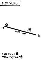
| Runways: | 09/27 |
| Longest Runway: | 09/27 is 7111 ft (2167 m) long |
| Runways with an Instrument Approach: | 09 |
TEX Airport Runway Details
| Runway 09/27 | 7111 ft x 100 ft (2167 m x 30 m) | |
| Runway Length Source: | 3RD PARTY SURVEY as of 09/14/2014 | |
| Surface: | Asphalt - Excellent condition - Saw-cut or plastic grooved | |
| Runway Pavement Class: | 35 /F/D/X/T | |
| Runway Edge Lights: | High Intensity | |
Runway Weight Bearing Capacity (in thousands of pounds) |
||
| Single Wheel Landing Gear: | 45.0 | |
| Dual Wheel Landing Gear: | 89.0 | |
Runway 09 |
Runway 27 |
|
Elevation: |
9038.1 | 9069.7 |
Latitude: |
37-57-22.7613N | 37-57-04.6807N |
Longitude: |
107-55-14.3475W | 107-53-48.5920W |
|
Runway True Alignment: |
105 | 285 |
ILS Type: |
LDA/DME | |
Glide Path Angle: |
3.5 degrees | 4.0 degrees |
Traffic Pattern: |
Right | |
Runway Markings Type: |
Nonprecision Instrument | Nonprecision Instrument |
Runway Markings Condition: |
Good | Good |
Arresting Device: |
EMAS | EMAS |
Visual Glide Slope Indicators: |
4-Light PAPI On Left Side Of Runway | 4-Light PAPI On Left Side Of Runway |
REIL: |
Yes | Yes |
Threshold Crossing Height: |
46 | 40 |
Threshold Elevation: |
9036.7 | 9068.1 |
Displaced Threshold: |
200 | 200 |
Threshold Latitude: |
37-57-22.2497N | 37-57-05.1896N |
Threshold Longitude: |
107-55-11.9365W | 107-53-51.0042W |
Declared Distances |
||
Take Off Run Avbl. (TORA): |
7111 | 7111 |
Take Off Distance Avbl. (TODA): |
7111 | 7111 |
Actual Stop Dist. Avbl. (ASDA): |
7111 | 7111 |
Landing Dist. Avbl. (LDA): |
6911 | 6911 |
Services
Airframe Repair: |
Major |
Powerplant Repair: |
Major |
Bottled Oxygen: |
Low Pressure |
Bulk Oxygen: |
High Pressure |
Fuel Available: |
100LL, Jet A |
Landing Fees: |
No |
Parking: |
Hangars and tiedowns available |
Maps & Diagrams
TEX Sectional
Flight Planning
at skyvector.com
at skyvector.com