Location
Latitude: |
38-38-34.3400N (38.642872) |
Longitude: |
088-57-51.0670W (-88.964185) |
Elevation: |
573.2 feet MSL (175 m MSL) |
Magnetic Variation: |
2.8 W (as of April 2024 from WMM2020 model) |
Time Zone: |
UTC -6.0 (Standard Time) UTC -5.0 (Daylight Savings Time) |
From City: |
02 N.M. NW of Salem, Illinois |
Found On: |
St Louis Chart |
FAA Region: |
AGL |
Contacts
Manager: |
Publicly owned: |
| ROBERT L.TATE JR 1100 AIRPORT RD SALEM, IL 62881 618-367-0114 |
SALEM AIRPORT AUTHORITY PO BOX 353 SALEM, IL 62881 618-367-0114 |
Operations
Airport Status: |
Operational |
Facility Use: |
Public |
Type: |
Airport |
Activation Date: |
12/1941 |
Control tower: |
No |
Attendance (Months/Days/Hours): |
Months/Days/Hours ALL/ALL/ALL |
Boundary ARTCC: |
ZKC (Kansas City) |
Responsible ARTCC: |
ZKC (Kansas City) |
Lighting Schedule: |
SEE RMK |
Segmented Circle Indicator: |
No |
Traffic Pattern Altitude (MSL): |
1573 feet (479 m) |
NOTAMs Facility: |
SLO |
NOTAM-D Service: |
Yes |
International Airport of Entry: |
No |
Customs Landing Rights: |
No |
Military Landing Rights: |
Yes |
Civil/Military Joint Use: |
No |
Based Aircraft
| Single Engine: | 11 |
Annual Operations (as of 05/31/2023)
| Total Operations: | 19000 | |
| Air Taxi: | 1000 | 5.3% |
| GA Local: | 11000 | 57.9% |
| GA Itinerant: | 7000 | 36.8% |
Communications
| CTAF: | 122.725 |
| Unicom: | 122.725 |
| AWOS-3PT: | 118.525 (956-587-0743) |
- APCH/DEP SVC PRVDD BY KANSAS CITY ARTCC ON FREQS 127.7/351.825 (MOUNT VERNON RCAG).
Fixed Based Operators (FBOs) & Fuel
(Click on a business for detail)
Please help us keep this information up to date. This is a FREE SERVICE just like everything else on Airport Guide! If you see that a business needs to be added, modified, or deleted please fill out our Update Form.
To add, modify, or delete a business click here.
Please help us keep this information up to date. This is a FREE SERVICE just like everything else on Airport Guide! If you see that a business needs to be added, modified, or deleted please fill out our Update Form.
Area Code: 618 |
| Business Name | Frequency | Phone | Fuel Grade |
|---|
Flight Service Stations
| Primary | Alternate | |
| FSS on Field: | N | |
| FSS Name (ID): | Saint Louis(STL) | |
| Frequency: | ||
| Toll Free Phone: | 1-800-WX-BRIEF |
Instrument Procedures / Charts
FAA Terminal Procedures valid from 0901Z 03/21/24 to 0901Z 04/18/24.
There are various types of charts available for an airport. They are listed in the Page Type column. Here is a legend for those types:
APD - Airport Diagram
DP - Departure Procedure Charts
HOT - Hot Spots
IAP - Instrument Approach Procedure Charts
MIN - Minimums
STAR - Standard Terminal Arrival Charts
| Page Type | Page Name | Volume | Action Since Last Cycle |
|---|---|---|---|
| IAP | RNAV (GPS) RWY 18 | EC-3 | |
| IAP | RNAV (GPS) RWY 36 | EC-3 | |
| MIN | ALTERNATE MINIMUMS | EC-3 | |
| MIN | TAKEOFF MINIMUMS | EC-3 |
Terminal Procedures are only available for airports in several countries with more being added all the time. If you are looking for a specific country's charts, please send an email to support(at)airportguide.com stating the country name. This will be used to prioritize the implementation.
Navigation Aids (Navaids) near SLO
| Dist (NM) | ID | Morse Code | Name | Type | Freq | True Hdg | Mag Hdg |
|---|---|---|---|---|---|---|---|
| 0.2 | SLO | . . . . _ . . _ _ _ | Salem | NDB | 400 | 294 | 297 |
| 16.2 | ENL | . _ . . _ . . | Centralia | VORTAC | 115.00 | 214 | 217 |
| 18.4 | VNN | . . . _ _ . _ . | Mount Vernon | DME | 113.8 | 156 | 159 |
| 28.0 | BIB | _ . . . . . _ . . . | Bible Grove | VORTAC | 109.00 | 53 | 56 |
| 28.6 | VLA | . . . _ . _ . . . _ | Vandalia | VOR-DME | 114.30 | 341 | 344 |
| 30.4 | FWC | . . _ . . _ _ _ . _ . | Wayne County | NDB | 257 | 120 | 123 |
| 37.4 | OLY | _ _ _ . _ . . _ . _ _ | Olney | NDB | 272 | 82 | 85 |
| 37.6 | JD | . _ _ _ _ . . | Gooey | NDB | 385 | 254 | 257 |
| 38.7 | BL | _ . . . . _ . . | Belleville | NDB | 362 | 254 | 257 |
| 42.0 | SKE | . . . _ . _ . | Scott | TACAN | 112.20 | 262 | 265 |
| 42.3 | SAM | . . . . _ _ _ | Samsville | DME | 116.6 | 102 | 105 |
| 45.1 | TOY | _ _ _ _ _ . _ _ | Troy | VORTAC | 116.00 | 277 | 279 |
| 46.2 | SYZ | . . . _ . _ _ _ _ . . | Shelbyville | NDB | 365 | 6 | 9 |
| 47.3 | AL | . _ . _ . . | Alpos | NDB | 218 | 285 | 287 |
| 48.2 | MD | _ _ _ . . | Cabbi | NDB | 388 | 196 | 199 |
| 48.2 | MW | _ _ . _ _ | Jonny | NDB | 382 | 180 | 183 |
| 51.9 | CP | _ . _ . . _ _ . | Acore | NDB | 350 | 262 | 264 |
| 53.2 | CVM | _ . _ . . . . _ _ _ | Civic Memorial | NDB | 263 | 286 | 288 |
| 53.4 | MWA | _ _ . _ _ . _ | Marion | DME | 110.4 | 182 | 185 |
| 53.6 | HSB | . . . . . . . _ . . . | Harrisburg-Raleigh | NDB | 230 | 158 | 161 |
Nearby Airports with Fuel
Notices to Airmen (NOTAMS)
Remarks
| A110-1 | FOR CD CTC KANSAS CITY ARTCC AT 913-254-8508. |
| A43-36 | RY 36 PAPI UNUSBL BYD 8 DEG LEFT AND RIGHT OF CNTRLN. |
| A70-FUEL-10 | 0LL 100LL IS SELF-SERVE W/CREDIT CARD. |
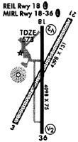
| A81-APT | MIRL RY 18/36 PRESET LOW INTST; TO INCR INTST & ACTVT PAPI RY 18/36, REIL RY 18/36 - CTAF. |
Runways
Runway Summary
| Runways: | 18/36 |
| Longest Runway: | 18/36 is 4098 ft (1249 m) long |
| Runways with an Instrument Approach: |
SLO Airport Runway Details
| Runway 18/36 | 4098 ft x 75 ft (1249 m x 23 m) | |
| Runway Length Source: | 3RD PARTY SURVEY as of 02/19/2011 | |
| Surface: | Asphalt - Good condition - No special surface treatment | |
| Runway Edge Lights: | Medium Intensity | |
Runway Weight Bearing Capacity (in thousands of pounds) |
||
| Single Wheel Landing Gear: | 12.0 | |
Runway 18 |
Runway 36 |
|
Elevation: |
573.1 | 563.0 |
Latitude: |
38-38-54.5765N | 38-38-14.0743N |
Longitude: |
088-57-50.9034W | 088-57-51.2487W |
|
Runway True Alignment: |
180 | 000 |
Glide Path Angle: |
3.0 degrees | 3.0 degrees |
Traffic Pattern: |
Left | Left |
Runway Markings Type: |
Nonprecision Instrument | Nonprecision Instrument |
Runway Markings Condition: |
Good | Good |
Visual Glide Slope Indicators: |
4-Light PAPI On Left Side Of Runway | 4-Light PAPI On Right Side Of Runway |
REIL: |
Yes | Yes |
Touchdown Lights: |
No | No |
Centerline Lights: |
No | No |
Threshold Crossing Height: |
39 | 28 |
Services
Airframe Repair: |
Major |
Powerplant Repair: |
Major |
Fuel Available: |
100LL, Jet A |
Landing Fees: |
No |
Parking: |
Hangars and tiedowns available |
Maps & Diagrams
SLO Sectional
Flight Planning
at skyvector.com
at skyvector.com