Location
Latitude: |
61-57-58.0050N (61.966113) |
Longitude: |
151-11-43.4050W (-151.19539) |
Elevation: |
148.0 feet MSL (45 m MSL) |
Magnetic Variation: |
14.3 E (as of April 2024 from WMM2020 model) |
Time Zone: |
UTC -9.0 (Standard Time) UTC -8.0 (Daylight Savings Time) |
From City: |
01 N.M. NE of Skwentna, Alaska |
Found On: |
Anchorage Chart |
FAA Region: |
AAL |
Contacts
Manager: |
Publicly owned: |
| KYLER HYLTON 289 INNER SPRING LOOP PALMER, AK 99645 (907) 745-2159 |
ALASKA DOT&PF CENTRAL REGION P.O. BOX 196900 ANCHORAGE, AK 99519-6900 907-269-0782 |
Operations
Airport Status: |
Operational |
Facility Use: |
Public |
Type: |
Airport |
Activation Date: |
05/1949 |
Control tower: |
No |
Attendance (Months/Days/Hours): |
Months/Days/Hours Unattended |
Boundary ARTCC: |
ZAN (Anchorage) |
Responsible ARTCC: |
ZAN (Anchorage) |
Lighting Schedule: |
SEE RMK |
Segmented Circle Indicator: |
Yes |
Traffic Pattern Altitude (MSL): |
1148 feet (350 m) |
NOTAMs Facility: |
SKW |
NOTAM-D Service: |
Yes |
International Airport of Entry: |
No |
Customs Landing Rights: |
No |
Military Landing Rights: |
Yes |
Civil/Military Joint Use: |
No |
Based Aircraft
Annual Operations (as of 12/31/2020)
| Total Operations: | 3500 | |
| Air Taxi: | 1000 | 28.6% |
| GA Itinerant: | 2500 | 71.4% |
Communications
| CTAF: | 122.900 |
Fixed Based Operators (FBOs) & Fuel
(Click on a business for detail)
Please help us keep this information up to date. This is a FREE SERVICE just like everything else on Airport Guide! If you see that a business needs to be added, modified, or deleted please fill out our Update Form.
To add, modify, or delete a business click here.
Please help us keep this information up to date. This is a FREE SERVICE just like everything else on Airport Guide! If you see that a business needs to be added, modified, or deleted please fill out our Update Form.
Area Code: 907 |
| Business Name | Frequency | Phone | Fuel Grade |
|---|
Flight Service Stations
| Primary | Alternate | |
| FSS on Field: | N | |
| FSS Name (ID): | Kenai(ENA) | |
| Frequency: | ||
| Toll Free Phone: | 1-866-864-1737 |
Instrument Procedures / Charts
Terminal Procedures are only available for airports in several countries with more being added all the time. If you are looking for a specific country's charts, please send an email to support(at)airportguide.com stating the country name. This will be used to prioritize the implementation.
Navigation Aids (Navaids) near SKW
| Dist (NM) | ID | Morse Code | Name | Type | Freq | True Hdg | Mag Hdg |
|---|---|---|---|---|---|---|---|
| 36.5 | TKA | _ _ . _ . _ | Talkeetna | VOR-DME | 116.20 | 56 | 42 |
| 37.8 | PEE | . _ _ . . . | Peters Creek | NDB | 305 | 54 | 40 |
| 42.2 | BGQ | _ . . . _ _ . _ _ . _ | Big Lake | VORTAC | 112.50 | 123 | 108 |
| 57.9 | CMQ | _ . _ . _ _ _ _ . _ | Campbell Lake | NDB | 338 | 144 | 130 |
| 59.0 | EDF | . _ . . . . _ . | Elmendorf | TACAN | 113.40 | 135 | 120 |
| 59.0 | ANC | . _ _ . _ . _ . | Anchorage | VOT | 108.40 | 143 | 129 |
| 59.2 | MRI | _ _ . _ . . . | Anchorage | VOT | 111.00 | 138 | 123 |
| 59.5 | TED | _ . _ . . | Anchorage | VOR-DME | 113.15 | 143 | 129 |
| 81.1 | ENA | . _ . . _ | Kenai | VOR-DME | 117.60 | 179 | 165 |
| 82.0 | IWW | . . . _ _ . _ _ | Wildwood | NDB | 379 | 180 | 166 |
| 89.9 | OLT | _ _ _ . _ . . _ | Soldotna | NDB-DME | 346 | 174 | 160 |
| 98.8 | UMM | . . _ _ _ _ _ | Summit | NDB | 326 | 34 | 19 |
Nearby Airports with Fuel
| Dist (NM) | Name (Airport IDs) | True Hdg | Mag Hdg | Fuel Grade |
|---|---|---|---|---|
| 37.5 | Talkeetna Airport (TKA PATK TKA) |
54 | 39 | 100LL, Jet A, Jet A+ |
| 52.6 | Wasilla Airport (WWA PAWS IYS) |
115 | 100 | 100LL, Jet A |
| 55.6 | Wasilla Lake Seaplane Base (5L6) |
113 | 98 | 100LL |
| 58.3 | Birchwood Airport (PABV BCV) |
123 | 108 | 100LL |
| 58.5 | Ted Stevens Anchorage International Airport (ANC PANC ANC) |
143 | 128 | 100, 100LL, Jet A, Jet A-1 |
| 59.4 | Merrill Field Airport (MRI PAMR MRI) |
138 | 123 | 100, Jet A |
| 59.7 | Alaska Regional Hospital Heliport (2OK) |
138 | 123 | 100LL, Jet A |
| 63.8 | Warren 'Bud' Woods Palmer Municipal Airport (PAQ PAAQ PAQ) |
109 | 94 | 100LL, Jet A-1 |
| 83.6 | Kenai Municipal Airport (ENA PAEN ENA) |
180 | 166 | 100LL, Jet A |
| 89.6 | Soldotna Airport (SXQ PASX SXQ) |
177 | 163 | 100LL, Jet A |
Notices to Airmen (NOTAMS)
Remarks
| A110-1 | SOFT DURG SPRING THAW; TWO 100 FT TWRS 1.5 NM WEST. |
| A110-2 | RWY CONDITION UNMONITORED. RECOMMEND VISUAL INSPECTION PRIOR TO LANDING. |
| A110-3 | WX CAMERA AVBL ON INTERNET AT HTTPS://WEATHERCAMS.FAA.GOV. |
| A110-4 | ATV ROAD CROSSES RWY 10, 900 FT FM THR. |
| A42-10 | NSTD MKGS RWY 10 & 28 MKD WITH REFLECTIVE CONES. THRS MARKED WITH REFLECTIVE PANELS. |
| A52-10 | 200 FT WIDE PATH CUT THROUGH TREES TO APCH. |
| A81-APT | ACTVT MIRL RWY 10/28; WINDSOCK - CTAF. |
| A81-BCN | ACTVT ROTG BCN - CTAF. |
Runways
Runway Summary
| Runways: | 10/28 |
| Longest Runway: | 10/28 is 3400 ft (1036 m) long |
| Runways with an Instrument Approach: |
SKW Airport Runway Details
| Runway 10/28 | 3400 ft x 75 ft (1036 m x 23 m) | |
| Runway Length Source: | STATE as of 06/14/2010 | |
| Surface: | Gravel - Good condition - No special surface treatment | |
| Runway Edge Lights: | Medium Intensity | |
Runway 10 |
Runway 28 |
|
Elevation: |
148.0 | 148.0 |
Latitude: |
61-58-05.4600N | 61-57-50.5500N |
Longitude: |
151-12-15.2400W | 151-11-11.5700W |
|
Runway True Alignment: |
116 | 296 |
Glide Path Angle: |
0.0 degrees | 0.0 degrees |
Traffic Pattern: |
Left | Left |
Runway Markings Type: |
Nonstandard (other than numbers only) | Nonstandard (other than numbers only) |
Runway Markings Condition: |
Good | Good |
Object at End: |
BRUSH | BRUSH |
Object Height: |
9 | 8 |
Distance from End: |
0 | 0 |
Object Centerline Offset: |
87 ft. left and right of centerline | 89 ft. left and right of centerline |
Services
Airframe Repair: |
Major |
Powerplant Repair: |
Major |
Fuel Available: |
100LL, Jet A |
Landing Fees: |
Yes |
Parking: |
Tiedowns available |
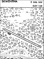
Maps & Diagrams
SKW Sectional
Flight Planning
at skyvector.com
at skyvector.com