Location
Latitude: |
43-23-37.7000N (43.393806) |
Longitude: |
070-42-28.8000W (-70.708) |
Elevation: |
244.1 feet MSL (74 m MSL) |
Magnetic Variation: |
14.5 W (as of April 2024 from WMM2020 model) |
Time Zone: |
UTC -5.0 (Standard Time) UTC -4.0 (Daylight Savings Time) |
From City: |
04 N.M. SE of Sanford, Maine |
Found On: |
New York Chart |
FAA Region: |
ANE |
Contacts
Manager: |
Publicly owned: |
| M. ALLISON NAVIA 9 PRESIDENTIAL LN SANFORD, ME 04073 207-324-3172 |
CITY OF SANFORD 919 MAIN ST SANFORD, ME 04073 (207) 324-9173 |
Operations
Airport Status: |
Operational |
Facility Use: |
Public |
Type: |
Airport |
Activation Date: |
04/1940 |
Control tower: |
No |
Attendance (Months/Days/Hours): |
Months/Days/Hours OCT-MAY/ALL/0700-1700 |
Boundary ARTCC: |
ZBW (Boston) |
Responsible ARTCC: |
ZBW (Boston) |
Lighting Schedule: |
SEE RMK |
Segmented Circle Indicator: |
Yes |
Traffic Pattern Altitude (MSL): |
1244 feet (379 m) |
NOTAMs Facility: |
SFM |
NOTAM-D Service: |
Yes |
International Airport of Entry: |
No |
Customs Landing Rights: |
No |
Military Landing Rights: |
Yes |
Civil/Military Joint Use: |
No |
Based Aircraft
| Single Engine: | 111 |
| Multi Engine: | 9 |
| Jet Engine: | 2 |
| GA Helicopters: | 10 |
| Gliders: | 3 |
| Ultralights: | 1 |
Annual Operations (as of 12/31/2022)
| Total Operations: | 36738 | |
| Air Taxi: | 1500 | 4.1% |
| GA Local: | 28000 | 76.2% |
| GA Itinerant: | 7138 | 19.4% |
| Military Aircraft: | 100 | 0.3% |
Communications
| CTAF: | 123.075 |
| Unicom: | 123.075 |
| Approach: | PORTLAND 119.75 119.75 119.75 BOSTON ARTCC |
| Departure: | PORTLAND 119.75 119.75 119.75 BOSTON ARTCC |
| AWOS-3PT: | 120.025 (207-324-1958) |
- APCH/DEP SVC PRVDD BY BOSTON ARTCC ON FREQS 128.2/263.05 (WATERBORO RCAG) WHEN PORTLAND APCH CTL CLSD.
Fixed Based Operators (FBOs) & Fuel
(Click on a business for detail)
Please help us keep this information up to date. This is a FREE SERVICE just like everything else on Airport Guide! If you see that a business needs to be added, modified, or deleted please fill out our Update Form.
To add, modify, or delete a business click here.
Please help us keep this information up to date. This is a FREE SERVICE just like everything else on Airport Guide! If you see that a business needs to be added, modified, or deleted please fill out our Update Form.
Area Code: 207 |
| Business Name | Frequency | Phone | Fuel Grade |
|---|---|---|---|
| American Jet Center
Update FBO info |
Unicom 122.8 | 324-0968, 800-519-2218 | 100LL, Jet A |
| American Jet-Sanford Air, Inc.
Update FBO info |
Unicom 122.8 | 324-0905 | 100LL, Jet A |
| Flightline Aviation
Update FBO info |
Unicom 122.8 | 324-5149 | 100LL, Jet A |
| Presidential Aviation, Inc.
Update FBO info |
324-8919 | 100LL, Jet A | |
| Rotorcraft, Inc.
Update FBO info |
324-0929 |
Flight Service Stations
| Primary | Alternate | |
| FSS on Field: | N | |
| FSS Name (ID): | Bangor(BGR) | |
| Frequency: | ||
| Toll Free Phone: | 1-800-WX-BRIEF |
Instrument Procedures / Charts
FAA Terminal Procedures valid from 0901Z 03/21/24 to 0901Z 04/18/24.
There are various types of charts available for an airport. They are listed in the Page Type column. Here is a legend for those types:
APD - Airport Diagram
DP - Departure Procedure Charts
HOT - Hot Spots
IAP - Instrument Approach Procedure Charts
MIN - Minimums
STAR - Standard Terminal Arrival Charts
| Page Type | Page Name | Volume | Action Since Last Cycle |
|---|---|---|---|
| IAP | ILS OR LOC RWY 07 | NE-1 | |
| IAP | RNAV (GPS) RWY 07 | NE-1 | |
| IAP | RNAV (GPS) RWY 25 | NE-1 | |
| IAP | RNAV (GPS) RWY 32 | NE-1 | |
| IAP | VOR RWY 25 | NE-1 | |
| MIN | ALTERNATE MINIMUMS | NE-1 | |
| MIN | TAKEOFF MINIMUMS | NE-1 |
Terminal Procedures are only available for airports in several countries with more being added all the time. If you are looking for a specific country's charts, please send an email to support(at)airportguide.com stating the country name. This will be used to prioritize the implementation.
Navigation Aids (Navaids) near SFM
| Dist (NM) | ID | Morse Code | Name | Type | Freq | True Hdg | Mag Hdg |
|---|---|---|---|---|---|---|---|
| 4.5 | ENE | . _ . . | Kennebunk | VOR-DME | 117.10 | 65 | 80 |
| 11.7 | ESG | . . . . _ _ . | Rollins | NDB | 260 | 206 | 220 |
| 19.3 | PSM | . _ _ . . . . _ _ | Pease | DME | 116.5 | 196 | 210 |
| 23.1 | PWM | . _ _ . . _ _ _ _ | Portland | VOT | 111.00 | 48 | 63 |
| 28.0 | PH | . _ _ . . . . . | Portland Lhb-P | MARINE NDB | 301 | 73 | 88 |
| 30.8 | SZO | . . . _ _ . . _ _ _ | Sebago | NDB | 227 | 354 | 369 |
| 33.6 | LCI | . _ . . _ . _ . . . | Laconia | FAN MARKER | 288 | 302 | |
| 36.5 | CO | _ . _ . _ _ _ | Epsom | NDB | 216 | 243 | 257 |
| 37.1 | LC | . _ . . _ . _ . | Blnap | NDB | 328 | 283 | 297 |
| 37.7 | LE | . _ . . . | Lewie | NDB | 240 | 25 | 40 |
| 39.3 | CON | _ . _ . _ _ _ _ . | Concord | VOR-DME | 112.90 | 254 | 268 |
| 42.7 | LWM | . _ . . . _ _ _ _ | Lawrence | DME | 112.5 | 203 | 217 |
| 42.8 | MHT | _ _ . . . . _ | Manchester | VOR-DME | 114.40 | 222 | 236 |
| 44.7 | NHZ | _ . . . . . _ _ . . | Brunswick | TACAN | 115.20 | 49 | 64 |
| 48.0 | MJ | _ _ . _ _ _ | Fitzy | NDB | 209 | 228 | 242 |
| 48.1 | BVY | _ . . . . . . _ _ . _ _ | Beverly | FAN MARKER | 192 | 206 | |
| 49.8 | LW | . _ . . . _ _ | Haget | NDB | 402 | 205 | 219 |
| 52.0 | AS | . _ . . . | Chern | NDB | 359 | 229 | 243 |
| 57.6 | LQ | . _ . . _ _ . _ | Lyndy | NDB | 382 | 191 | 205 |
| 60.0 | SKR | . . . _ . _ . _ . | Shaker Hill | NDB | 251 | 200 | 214 |
Nearby Airports with Fuel
Notices to Airmen (NOTAMS)
Remarks
| A110-1 | WILDLIFE ON & INVOF ARPT. |
| A110-10 | HIGH VOL FIXED AND ROTARY WING FLT TRNG IN VCNTY. |
| A110-2 | CALM WIND PREFERRED RWY 32. |
| A110-3 | 24 HR FUEL AVBL WITH MAJOR CREDIT CARD FOR 100LL, A & MOGAS. |
| A110-5 | CONDS NOT MNT DLY 1600-0700 EST. |
| A110-6 | FBO AFT HRS CALL-OUT FEE - 207-324-8919. |
| A110-7 | FOR CD WHEN APCH CLSD CTC BOSTON ARTCC AT 603-879-6859. |
| A57-07 | APCH RATIO 49:1 AT DTHR. |
| A57-14 | APCH RATIO 20:1 AT DTHR. |
| A81-APT | ACTVT ODALS RWY 25; REIL RWY 07; PAPI RWY 07 & 25; HIRL 07/25; MIRL 14/32; TWY LGTS - CTAF. TWY LGTS INOP DALGT HRS. |
| E111 | EXISTED PRIOR TO 1959. |
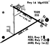
Runways
Runway Summary
| Runways: | 07/25 14/32 |
| Longest Runway: | 07/25 is 6389 ft (1947 m) long |
| Runways with an Instrument Approach: | 07 |
SFM Airport Runway Details
| Runway 07/25 | 6389 ft x 100 ft (1947 m x 30 m) | |
| Runway Length Source: | 3RD PARTY SURVEY as of 06/12/2012 | |
| Surface: | Asphalt - Good condition - Saw-cut or plastic grooved | |
| Runway Edge Lights: | High Intensity | |
Runway Weight Bearing Capacity (in thousands of pounds) |
||
| Single Wheel Landing Gear: | 65.0 | |
| Dual Wheel Landing Gear: | 100.0 | |
Runway 07 |
Runway 25 |
|
Elevation: |
240.5 | 232.1 |
Latitude: |
43-23-12.0113N | 43-23-45.1011N |
Longitude: |
070-43-11.0761W | 070-41-57.4240W |
|
Runway True Alignment: |
058 | 238 |
ILS Type: |
ILS | |
Glide Path Angle: |
3.0 degrees | 3.0 degrees |
Traffic Pattern: |
Left | Left |
Runway Markings Type: |
Precision Instrument | Nonprecision Instrument |
Runway Markings Condition: |
Good | Good |
Object at End: |
TREE | PLINE |
Object Height: |
30 | 18 |
Distance from End: |
1074 | 695 |
Object Centerline Offset: |
278 ft. left of centerline | 460 ft. right of centerline |
Visual Glide Slope Indicators: |
4-Light PAPI On Left Side Of Runway | 4-Light PAPI On Left Side Of Runway |
Approach Light System: |
Omnidirectional Approach Lighting System | |
REIL: |
Yes | |
Touchdown Lights: |
No | No |
Centerline Lights: |
No | No |
Threshold Crossing Height: |
53 | 47 |
Threshold Elevation: |
233.1 | |
Displaced Threshold: |
388 | |
Threshold Latitude: |
43-23-43.0921N | |
Threshold Longitude: |
070-42-01.8976W |
| Runway 14/32 | 4999 ft x 100 ft (1524 m x 30 m) | |
| Runway Length Source: | 3RD PARTY SURVEY as of 03/08/2011 | |
| Surface: | Asphalt - Good condition - No special surface treatment | |
| Runway Edge Lights: | Medium Intensity | |
Runway Weight Bearing Capacity (in thousands of pounds) |
||
| Dual Wheel Landing Gear: | 72.0 | |
Runway 14 |
Runway 32 |
|
Elevation: |
244.0 | 230.7 |
Latitude: |
43-24-01.2346N | 43-23-37.3650N |
Longitude: |
070-42-51.5048W | 070-41-52.2291W |
|
Runway True Alignment: |
119 | 299 |
Glide Path Angle: |
4.0 degrees | 3.0 degrees |
Traffic Pattern: |
Left | Left |
Runway Markings Type: |
Basic | Basic |
Runway Markings Condition: |
Good | Good |
Object at End: |
TREE | |
Object Height: |
68 | |
Distance from End: |
516 | |
Object Centerline Offset: |
278 ft. left of centerline | 460 ft. right of centerline |
Visual Glide Slope Indicators: |
4-Light PAPI On Left Side Of Runway | 4-Light PAPI On Left Side Of Runway |
REIL: |
No | No |
Touchdown Lights: |
No | No |
Centerline Lights: |
No | No |
Threshold Crossing Height: |
21 | 34 |
Threshold Elevation: |
241.8 | |
Displaced Threshold: |
885 | |
Threshold Latitude: |
43-23-57.0094N | |
Threshold Longitude: |
070-42-41.0098W |
Services
Airframe Repair: |
Minor |
Powerplant Repair: |
Minor |
Bottled Oxygen: |
None |
Bulk Oxygen: |
None |
Fuel Available: |
100LL |
Landing Fees: |
No |
Parking: |
Hangars and tiedowns available |
Maps & Diagrams
SFM Sectional
Flight Planning
at skyvector.com
at skyvector.com