Location
Latitude: |
70-11-41.1148N (70.194754) |
Longitude: |
148-27-54.5935W (-148.465165) |
Elevation: |
67.4 feet MSL (21 m MSL) |
Magnetic Variation: |
15.2 E (as of April 2024 from WMM2020 model) |
Time Zone: |
UTC -9.0 (Standard Time) UTC -8.0 (Daylight Savings Time) |
From City: |
00 N.M. SE of Deadhorse, Alaska |
Found On: |
Point Barrow Chart |
FAA Region: |
AAL |
Contacts
Manager: |
Publicly owned: |
| TIM PARAULT POUCH 340002 PRUDHOE BAY, AK 99734 907-328-7130 |
ALASKA DOT&PF NORTHERN REGION 2301 PEGER RD FAIRBANKS, AK 99709 907-451-2200 |
Operations
Airport Status: |
Operational |
Facility Use: |
Public |
Type: |
Airport |
Activation Date: |
04/1970 |
Control tower: |
No |
Attendance (Months/Days/Hours): |
Months/Days/Hours ALL/ALL/0600-1830 |
Boundary ARTCC: |
ZAN (Anchorage) |
Responsible ARTCC: |
ZAN (Anchorage) |
Lighting Schedule: |
SEE RMK |
Segmented Circle Indicator: |
Yes |
Traffic Pattern Altitude (MSL): |
1067 feet (325 m) |
NOTAMs Facility: |
SCC |
NOTAM-D Service: |
Yes |
International Airport of Entry: |
No |
Customs Landing Rights: |
No |
Military Landing Rights: |
Yes |
Civil/Military Joint Use: |
No |
Aircraft Rescue and Firefighting: |
Class I ARFF Index: B Air Carrier Service: Scheduled Certification Date: 03/2005 |
Based Aircraft
| Single Engine: | 3 |
| Multi Engine: | 2 |
| GA Helicopters: | 5 |
Annual Operations (as of 07/31/2019)
| Total Operations: | 21324 | |
| Commercial: | 5616 | 26.3% |
| Air Taxi: | 3432 | 16.1% |
| GA Local: | 9126 | 42.8% |
| GA Itinerant: | 3000 | 14.1% |
| Military Aircraft: | 150 | 0.7% |
Communications
| CTAF: | 123.600 |
| Unicom: | 123.000 |
| Approach: | ANCHORAGE ARTCC |
| Departure: | ANCHORAGE ARTCC |
| ATIS: | Hrs: 24. |
| ASOS: | 118.4 (907-659-2591) |
| AFIS: | 118.4 |
- APCH/DEP SVC PRVDD BY ANCHORAGE ARTCC ON FREQS 134.4/370.9 (DEADHORSE RCAG).
- AFIS FREQUENCY 118.4. OPERATES SAME HRS AS SCC FSS, 0600-2130.
- COMMUNICATIONS PRVDD BY DEADHORSE FSS ON FREQ 123.6 (CTAF).
Fixed Based Operators (FBOs) & Fuel
(Click on a business for detail)
Please help us keep this information up to date. This is a FREE SERVICE just like everything else on Airport Guide! If you see that a business needs to be added, modified, or deleted please fill out our Update Form.
To add, modify, or delete a business click here.
Please help us keep this information up to date. This is a FREE SERVICE just like everything else on Airport Guide! If you see that a business needs to be added, modified, or deleted please fill out our Update Form.
Area Code: 907 |
| Business Name | Frequency | Phone | Fuel Grade |
|---|---|---|---|
| Colville, Inc.
Update FBO info |
659-3198 | 100LL, Jet A | |

|
 Texaco |
100LL - 3.01 USD per gallon on 8/18/01 |
Trucks |
|
|
Texaco |
Jet A - 2.00 USD per gallon on 8/18/01 |
Trucks |
| Nana Oilfield Service
Update FBO info |
659-2840 | 100LL, Jet B, Mogas | |
|
|
Chevron |
100LL - 3.33 USD per gallon on 8/18/01 |
Pumps |
|
|
Chevron |
Jet A - 2.82 USD per gallon on 8/18/01 |
Pumps |
|
|
Chevron |
MOGAS - 2.01 USD per gallon on 8/18/01 |
Pumps |
Flight Service Stations
| Primary | Alternate | |
| FSS on Field: | Y | |
| FSS Name (ID): | Deadhorse(SCC) | Fairbanks (FAI) |
| Frequency: | ||
| Toll Free Phone: | LC659-2401 | 1-866-248-6516 |
Instrument Procedures / Charts
FAA Terminal Procedures valid from 0901Z 03/21/24 to 0901Z 04/18/24.
There are various types of charts available for an airport. They are listed in the Page Type column. Here is a legend for those types:
APD - Airport Diagram
DP - Departure Procedure Charts
HOT - Hot Spots
IAP - Instrument Approach Procedure Charts
MIN - Minimums
STAR - Standard Terminal Arrival Charts
| Page Type | Page Name | Volume | Action Since Last Cycle |
|---|---|---|---|
| IAP | ILS OR LOC RWY 06 | AK-1 | |
| IAP | LOC BC RWY 24 | AK-1 | |
| IAP | RNAV (GPS) Z RWY 06 | AK-1 | |
| IAP | RNAV (GPS) Z RWY 24 | AK-1 | |
| IAP | VOR RWY 06 | AK-1 | |
| IAP | VOR Y RWY 24 | AK-1 | Changed |
| IAP | VOR Z RWY 24 | AK-1 | Changed |
| MIN | ALTERNATE MINIMUMS | AK-1 | |
| MIN | TAKEOFF MINIMUMS | AK-1 |
Terminal Procedures are only available for airports in several countries with more being added all the time. If you are looking for a specific country's charts, please send an email to support(at)airportguide.com stating the country name. This will be used to prioritize the implementation.
Navigation Aids (Navaids) near SCC
| Dist (NM) | ID | Morse Code | Name | Type | Freq | True Hdg | Mag Hdg |
|---|---|---|---|---|---|---|---|
| 1.0 | SCC | . . . _ . _ . _ . _ . | Deadhorse | VOR-DME | 113.90 | 74 | 59 |
| 1.9 | PVQ | . _ _ . . . . _ _ _ . _ | Put River | NDB | 376 | 30 | 15 |
| 25.0 | PYC | . _ _ . _ . _ _ _ . _ . | Pitsand | NDB | 290 | 289 | 274 |
| 51.5 | UQS | . . _ _ _ . _ . . . | Nuiqsut Village | NDB | 241 | 272 | 257 |
Nearby Airports with Fuel
| Dist (NM) | Name (Airport IDs) | True Hdg | Mag Hdg | Fuel Grade |
|---|---|---|---|---|
| 90.7 | Umiat Airport (UMT PAUM UMT) |
238 | 224 | 100LL, Jet A |
Notices to Airmen (NOTAMS)
Remarks
| A110-1 | WATERFOWL INVOF ARPT; CARIBOU ON RWY & MOV AREAS. |
| A110-11 | ARFF SVC PPR IN WRITING - AMGR. |
| A110-13 | AVN CNTR PVT PPR - 907-538-3600. |
| A110-18 | TSA REGULATED; SEE 49 CFR 1542. ALL GATES & DOORS MUST BE SECURED AT ALL TIMES. TSNT OR UNFAMILIAR PILOTS - AMGR FOR INFO. |
| A110-19 | COLVILLE RAMP CLSD DUE TO PAVEMENT DAMAGE UFN. |
| A110-5 | WX OBS WHEN DEADHORSE FSS CLSD - 133.55 OR 907-659-2401. |
| A110-8 | ARPT MAINT DUTY HRS 0600-1830; AIRFIELD SVC AFT HR - AMGR. |
| A110-9 | WX CAMERA AVBL ON INTERNET AT HTTPS://WEATHERCAMS.FAA.GOV |
| A26 | CLSD TO ACR OPS MORE THAN 30 PAX SEATS EXC PPR IN WRITING - AMGR PO BOX 340002 PRUDHOE BAY AK 99734. |
| A70-FUEL-A | AVBL 0600-1800 - 122.85 OR 907-659-6215. |
| A81-APT | WHEN FSS CLSD ACVT MALSR RWY 06 & 24; HIRL RWY 06/24 - CTAF. HIRL RWY 06/24 PRESET LOW INTST; INCR INTST - 123.6. |
Runways
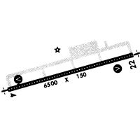
Runway Summary
| Runways: | 06/24 |
| Longest Runway: | 06/24 is 6500 ft (1981 m) long |
| Runways with an Instrument Approach: | 06 |
SCC Airport Runway Details
| Runway 06/24 | 6500 ft x 150 ft (1981 m x 46 m) | |
| Runway Length Source: | 3RD PARTY SURVEY as of 08/15/2009 | |
| Surface: | Asphalt - Good condition - Saw-cut or plastic grooved | |
| Runway Pavement Class: | 76 /F/A/W/T | |
| Runway Edge Lights: | High Intensity | |
Runway Weight Bearing Capacity (in thousands of pounds) |
||
| Single Wheel Landing Gear: | 120.0 | |
| Dual Wheel Landing Gear: | 250.0 | |
| Dual Tandem Wheel Landing Gear: | 550.0 | |
Runway 06 |
Runway 24 |
|
Elevation: |
66.9 | 60.7 |
Latitude: |
70-11-32.8479N | 70-11-49.3816N |
Longitude: |
148-29-25.6497W | 148-26-23.5373W |
|
Runway True Alignment: |
075 | 255 |
ILS Type: |
ILS/DME | |
Glide Path Angle: |
3.0 degrees | 3.0 degrees |
Traffic Pattern: |
Right | Left |
Runway Markings Type: |
Precision Instrument | Precision Instrument |
Runway Markings Condition: |
Good | Good |
Visual Glide Slope Indicators: |
4-Box VASI On Left Side Of Runway | 4-Box VASI On Left Side Of Runway |
Runway Visual Range (RVR): |
Touchdown | Touchdown |
Approach Light System: |
1,400 Foot Medium Intensity Approach Lighting System With Runway Alignment Indicator Lights | 1,400 Foot Medium Intensity Approach Lighting System With Runway Alignment Indicator Lights |
Touchdown Lights: |
No | No |
Centerline Lights: |
Yes | Yes |
Threshold Crossing Height: |
50 | 54 |
Declared Distances |
||
Take Off Run Avbl. (TORA): |
6500 | 6500 |
Take Off Distance Avbl. (TODA): |
6500 | 6500 |
Actual Stop Dist. Avbl. (ASDA): |
6500 | 6500 |
Landing Dist. Avbl. (LDA): |
6500 | 6500 |
Services
Airframe Repair: |
None |
Powerplant Repair: |
None |
Bottled Oxygen: |
None |
Bulk Oxygen: |
None |
Fuel Available: |
100LL, Jet A |
Landing Fees: |
No |
Maps & Diagrams
SCC Sectional
Flight Planning
at skyvector.com
at skyvector.com