Location
Latitude: |
44-52-36.4000N (44.876778) |
Longitude: |
124-01-42.8000W (-124.028556) |
Elevation: |
69.2 feet MSL (21 m MSL) |
Magnetic Variation: |
14.9 E (as of April 2024 from WMM2020 model) |
Time Zone: |
UTC -8.0 (Standard Time) UTC -7.0 (Daylight Savings Time) |
From City: |
01 N.M. SE of Gleneden Beach, Oregon |
Found On: |
Seattle Chart |
FAA Region: |
ANM |
Contacts
Manager: |
Publicly owned: |
| STATE AIRPORTS MANAGER 3040 25TH ST SE SALEM, OR 97302-1125 503-378-4880 |
OREGON DEPT. OF AVIATION 3040 25TH ST SE SALEM, OR 97302-1125 503-378-4880 |
Operations
Airport Status: |
Operational |
Facility Use: |
Public |
Type: |
Airport |
Activation Date: |
11/1971 |
Control tower: |
No |
Attendance (Months/Days/Hours): |
Months/Days/Hours Unattended |
Boundary ARTCC: |
ZSE (Seattle) |
Responsible ARTCC: |
ZSE (Seattle) |
Lighting Schedule: |
SEE RMK |
Segmented Circle Indicator: |
Yes |
Traffic Pattern Altitude (MSL): |
1069 feet (326 m) |
NOTAMs Facility: |
MMV |
NOTAM-D Service: |
Yes |
International Airport of Entry: |
No |
Customs Landing Rights: |
No |
Military Landing Rights: |
Yes |
Civil/Military Joint Use: |
No |
Based Aircraft
| Single Engine: | 11 |
Annual Operations (as of 08/29/2017)
| Total Operations: | 3880 | |
| GA Local: | 2000 | 51.5% |
| GA Itinerant: | 1830 | 47.2% |
| Military Aircraft: | 50 | 1.3% |
Communications
| CTAF: | 122.700 |
| Unicom: | 122.700 |
Fixed Based Operators (FBOs) & Fuel
(Click on a business for detail)
Please help us keep this information up to date. This is a FREE SERVICE just like everything else on Airport Guide! If you see that a business needs to be added, modified, or deleted please fill out our Update Form.
To add, modify, or delete a business click here.
Please help us keep this information up to date. This is a FREE SERVICE just like everything else on Airport Guide! If you see that a business needs to be added, modified, or deleted please fill out our Update Form.
Area Code: 503 |
| Business Name | Frequency | Phone | Fuel Grade |
|---|---|---|---|
| Sunset Scenic Flights
Update FBO info |
Unicom 122.7 | 764-3304 |
Flight Service Stations
| Primary | Alternate | |
| FSS on Field: | N | |
| FSS Name (ID): | Mc Minnville(MMV) | |
| Frequency: | ||
| Toll Free Phone: | 1-800-WX-BRIEF |
Instrument Procedures / Charts
Terminal Procedures are only available for airports in several countries with more being added all the time. If you are looking for a specific country's charts, please send an email to support(at)airportguide.com stating the country name. This will be used to prioritize the implementation.
Navigation Aids (Navaids) near S45
| Dist (NM) | ID | Morse Code | Name | Type | Freq | True Hdg | Mag Hdg |
|---|---|---|---|---|---|---|---|
| 18.1 | ONP | _ _ _ _ . . _ _ . | Newport | VORTAC | 117.10 | 184 | 169 |
| 35.9 | LWG | . _ . . . _ _ _ _ . | Lewisburg | NDB | 225 | 115 | 100 |
| 38.7 | CVO | _ . _ . . . . _ _ _ _ | Corvallis | VOR-DME | 115.40 | 125 | 110 |
| 45.9 | SL | . . . . _ . . | Turno | NDB | 266 | 91 | 76 |
| 52.7 | EU | . . . _ | Frakk | NDB | 260 | 138 | 123 |
| 52.9 | UBG | . . _ _ . . . _ _ . | Newberg | VOR-DME | 117.40 | 56 | 41 |
| 57.0 | EUG | . . . _ _ _ . | Eugene | VORTAC | 112.90 | 142 | 127 |
| 60.6 | HIO | . . . . . . _ _ _ | Hillsboro | VOT | 115.20 | 48 | 33 |
| 61.4 | PND | . _ _ . _ . _ . . | Banks | NDB | 356 | 42 | 27 |
| 73.6 | CBU | _ . _ . _ . . . . . _ | Columbia | TACAN | 109.20 | 54 | 39 |
| 73.9 | PDX | . _ _ . _ . . _ . . _ | Portland | VOR-DME | 111.80 | 53 | 38 |
| 74.1 | PDX | . _ _ . _ . . _ . . _ | Portland | VOT | 111.00 | 53 | 38 |
| 77.3 | LBH | . _ . . _ . . . . . . . | Laker | NDB | 332 | 58 | 43 |
| 77.3 | AST | . _ . . . _ | Astoria | VOR-DME | 114.00 | 4 | 349 |
| 78.0 | PEN | . _ _ . . _ . | Karpen | NDB | 201 | 13 | 358 |
| 79.9 | AST | . _ . . . _ | Fort Stevens | FAN MARKER | 1 | 346 | |
| 80.0 | BTG | _ . . . _ _ _ . | Battle Ground | VORTAC | 116.60 | 48 | 33 |
| 87.9 | OTH | _ _ _ _ . . . . | North Bend | VOR-DME | 112.10 | 183 | 168 |
| 89.8 | OT | _ _ _ _ | Emire | NDB | 378 | 187 | 172 |
| 89.9 | LSO | . _ . . . . . _ _ _ | Kelso | NDB | 256 | 31 | 16 |
Nearby Airports with Fuel
Notices to Airmen (NOTAMS)
Remarks
| A110-1 | WILDLIFE ON AND INVOF OF AIRPORT. |
| A110-2 | FOR CD CTC SEATTLE ARTCC AT 253-351-3694. |
| A110-3 | SFC CONDS NOT RPRTD. |
| A58-17 | 35' TREES 0-200' FM RY END 105-120' L OF CNTRLN. |
| A58-35 | RWY 35 10 FT BRUSH AT 75-200 FT FM RWY END & 90-125 FT L OF CNTRLN. |
| A81-APT | MIRL RY 17/35 PRESET LOW INTST; ACTVT HIGHER INTST - CTAF. |
| A82 | UNICOM ATTENDED IRREGULARLY. |
Runways
Runway Summary
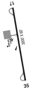
| Runways: | 17/35 |
| Longest Runway: | 17/35 is 3297 ft (1005 m) long |
| Runways with an Instrument Approach: |
S45 Airport Runway Details
| Runway 17/35 | 3297 ft x 60 ft (1005 m x 18 m) | |
| Runway Length Source: | 3RD PARTY SURVEY as of 08/09/2009 | |
| Surface: | Asphalt - Fair condition - No special surface treatment | |
| Runway Edge Lights: | Medium Intensity | |
Runway Weight Bearing Capacity (in thousands of pounds) |
||
| Single Wheel Landing Gear: | 11.0 | |
Runway 17 |
Runway 35 |
|
Elevation: |
59.3 | 69.2 |
Latitude: |
44-52-52.4206N | 44-52-20.4497N |
Longitude: |
124-01-38.4849W | 124-01-47.1240W |
|
Runway True Alignment: |
191 | 011 |
Glide Path Angle: |
0.0 degrees | 0.0 degrees |
Traffic Pattern: |
Right | Left |
Runway Markings Type: |
Basic | Basic |
Runway Markings Condition: |
Fair | Fair |
Object at End: |
TREES | TREES |
Object Height: |
88 | 23 |
Distance from End: |
960 | 323 |
Object Centerline Offset: |
125 ft. left of centerline | 69 ft. left and right of centerline |
Services
Airframe Repair: |
Major |
Powerplant Repair: |
Major |
Bottled Oxygen: |
None |
Bulk Oxygen: |
None |
Fuel Available: |
100LL, Jet A |
Landing Fees: |
No |
Parking: |
Tiedowns available |
Maps & Diagrams
S45 Sectional
Flight Planning
at skyvector.com
at skyvector.com