Location
Latitude: |
47-25-21.9850N (47.422774) |
Longitude: |
098-06-21.1370W (-98.105871) |
Elevation: |
1424.4 feet MSL (434 m MSL) |
Magnetic Variation: |
3.6 E (as of April 2024 from WMM2020 model) |
Time Zone: |
UTC -6.0 (Standard Time) UTC -5.0 (Daylight Savings Time) |
From City: |
02 N.M. SE of Cooperstown, North Dakota |
Found On: |
Twin Cities Chart |
FAA Region: |
AGL |
Contacts
Manager: |
Publicly owned: |
| LORAN ANDERSON 301 13TH ST SE COOPERSTOWN, ND 58425 701-309-1201 |
COOPERSTOWN ARPT AUTH P.O. BOX 486 COOPERSTOWN, ND 58425 701-789-0667 |
Operations
Airport Status: |
Operational |
Facility Use: |
Public |
Type: |
Airport |
Activation Date: |
11/1947 |
Control tower: |
No |
Attendance (Months/Days/Hours): |
Months/Days/Hours OCT-APR/ALL/ON CALL |
Boundary ARTCC: |
ZMP (Minneapolis) |
Responsible ARTCC: |
ZMP (Minneapolis) |
Lighting Schedule: |
SEE RMK |
Segmented Circle Indicator: |
Yes |
Traffic Pattern Altitude (MSL): |
2424 feet (739 m) |
NOTAMs Facility: |
GFK |
NOTAM-D Service: |
Yes |
Military Landing Rights: |
Yes |
Civil/Military Joint Use: |
No |
Based Aircraft
| Single Engine: | 12 |
| Multi Engine: | 1 |
Annual Operations (as of 10/20/2021)
| Total Operations: | 3340 | |
| Air Taxi: | 500 | 15.0% |
| GA Local: | 2000 | 59.9% |
| GA Itinerant: | 800 | 24.0% |
| Military Aircraft: | 40 | 1.2% |
Communications
| CTAF: | 122.900 |
| AWOS-3: | 118.750 (701-797-2566) |
- COMMUNICATIONS PRVDD BY GRAND FORKS RADIO ON FREQ 122.2 (JAMESTOWN RCO).
- APCH/DEP SVC PRVDD BY MINNEAPOLIS ARTCC (ZMP) ON FREQ 132.15/269.6 (GRAND FORKS RCAG).
Fixed Based Operators (FBOs) & Fuel
(Click on a business for detail)
Please help us keep this information up to date. This is a FREE SERVICE just like everything else on Airport Guide! If you see that a business needs to be added, modified, or deleted please fill out our Update Form.
To add, modify, or delete a business click here.
Please help us keep this information up to date. This is a FREE SERVICE just like everything else on Airport Guide! If you see that a business needs to be added, modified, or deleted please fill out our Update Form.
Area Code: 701 |
| Business Name | Frequency | Phone | Fuel Grade |
|---|
Flight Service Stations
| Primary | Alternate | |
| FSS on Field: | N | |
| FSS Name (ID): | Grand Forks(GFK) | |
| Frequency: | ||
| Toll Free Phone: | 1-800-WX-BRIEF |
Instrument Procedures / Charts
FAA Terminal Procedures valid from 0901Z 03/21/24 to 0901Z 04/18/24.
There are various types of charts available for an airport. They are listed in the Page Type column. Here is a legend for those types:
APD - Airport Diagram
DP - Departure Procedure Charts
HOT - Hot Spots
IAP - Instrument Approach Procedure Charts
MIN - Minimums
STAR - Standard Terminal Arrival Charts
| Page Type | Page Name | Volume | Action Since Last Cycle |
|---|---|---|---|
| IAP | RNAV (GPS) RWY 13 | NC-1 | |
| IAP | RNAV (GPS) RWY 31 | NC-1 | |
| MIN | TAKEOFF MINIMUMS | NC-1 |
Terminal Procedures are only available for airports in several countries with more being added all the time. If you are looking for a specific country's charts, please send an email to support(at)airportguide.com stating the country name. This will be used to prioritize the implementation.
Navigation Aids (Navaids) near S32
| Dist (NM) | ID | Morse Code | Name | Type | Freq | True Hdg | Mag Hdg |
|---|---|---|---|---|---|---|---|
| 37.5 | JMS | . _ _ _ _ _ . . . | Jamestown | VOR-DME | 114.50 | 218 | 214 |
| 38.8 | JM | . _ _ _ _ _ | Sabon | NDB | 395 | 210 | 206 |
| 42.7 | RDR | . _ . _ . . . _ . | Red River | TACAN | 116.40 | 41 | 38 |
| 45.2 | GF | _ _ . . . _ . | Hiser | NDB | 345 | 55 | 52 |
| 49.0 | GFK | _ _ . . . _ . _ . _ | Grand Forks | VOR-DME | 114.30 | 49 | 46 |
| 52.8 | DVL | _ . . . . . _ . _ . . | Devils Lake | VOR-DME | 114.75 | 322 | 318 |
| 58.2 | AA | . _ . _ | Kenie | NDB | 365 | 114 | 111 |
| 65.1 | FAR | . . _ . . _ . _ . | Fargo | VOR-DME | 116.20 | 127 | 124 |
| 65.2 | CKN | _ . _ . _ . _ _ . | Crookston | NDB | 400 | 66 | 63 |
| 74.4 | GWR | _ _ . . _ _ . _ . | Gwinner | NDB | 278 | 165 | 162 |
| 86.6 | TVF | _ . . . _ . . _ . | Thief River Falls | VOR-DME | 114.45 | 62 | 59 |
| 88.4 | HY | . . . . _ . _ _ | Harvi | NDB | 260 | 65 | 62 |
| 93.8 | BWP | _ . . . . _ _ . _ _ . | Breckenridge-Wahpeton | NDB | 233 | 138 | 135 |
| 95.2 | FSE | . . _ . . . . . | Fosston | NDB | 224 | 83 | 80 |
| 95.4 | HML | . . . . _ _ . _ . . | Humboldt | TACAN | 112.40 | 24 | 21 |
| 97.4 | DTL | _ . . _ . _ . . | Detroit Lakes | VOR-DME | 111.20 | 110 | 107 |
Nearby Airports with Fuel
Notices to Airmen (NOTAMS)
Remarks
| A11 | LORAN ANDERSON - CHRMN ARPT AUTH. |
| A110-1 | CONFIRM WINTER COND & SNOW REMOVAL WITH AMGR. |
| A110-2 | HELICOPTER LNDG AREA LCTD EAST APRON EDGE; SNOW REMOVAL IREG. |
| A110-3 | BIRDS & DEER INVOF ARPT. |
| A110-4 | FOR CD CTC MINNEAPOLIS ARTCC AT 651-463-5588. |
| A16 | ADNL PHONE - CITY POLICE 701-797-2202. |
| A70-FUEL-10 | 0LL SELF SVC FUEL AVBL H24. |
| A76 | FOR AGRI SVC CRC AMGR APR-OCT. |
| A81-APT | MIRL ON RY 13/31 PRESET ON LOW INTST; TO INCR INTST & ACTIVATE RYS 13, 31 PAPI - CTAF. |
Runways
Runway Summary
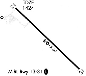
| Runways: | 13/31 |
| Longest Runway: | 13/31 is 3500 ft (1067 m) long |
| Runways with an Instrument Approach: |
S32 Airport Runway Details
| Runway 13/31 | 3500 ft x 60 ft (1067 m x 18 m) | |
| Surface: | Asphalt - Fair condition - No special surface treatment | |
| Runway Edge Lights: | Medium Intensity | |
Runway Weight Bearing Capacity (in thousands of pounds) |
||
| Single Wheel Landing Gear: | 12.5 | |
Runway 13 |
Runway 31 |
|
Elevation: |
1422.2 | 1421.1 |
Latitude: |
47-25-34.1400N | 47-25-09.8700N |
Longitude: |
098-06-39.2000W | 098-06-03.0000W |
|
Runway True Alignment: |
135 | 315 |
Glide Path Angle: |
3.0 degrees | 3.0 degrees |
Traffic Pattern: |
Left | Left |
Runway Markings Type: |
Nonprecision Instrument | Nonprecision Instrument |
Runway Markings Condition: |
Fair | Fair |
Visual Glide Slope Indicators: |
2-Light PAPI On Left Side Of Runway | 2-Light PAPI On Left Side Of Runway |
Threshold Crossing Height: |
25 | 25 |
Services
Fuel Available: |
100LL, MOGAS |
Landing Fees: |
No |
Parking: |
Tiedowns available |
Maps & Diagrams
S32 Sectional
Flight Planning
at skyvector.com
at skyvector.com