Location
Latitude: |
40-40-38.6000N (40.677389) |
Longitude: |
077-37-36.6000W (-77.626833) |
Elevation: |
818.8 feet MSL (250 m MSL) |
Magnetic Variation: |
10.7 W (as of April 2024 from WMM2020 model) |
Time Zone: |
UTC -5.0 (Standard Time) UTC -4.0 (Daylight Savings Time) |
From City: |
05 N.M. NW of Reedsville, Pennsylvania |
Found On: |
Detroit Chart |
FAA Region: |
AEA |
Contacts
Manager: |
Publicly owned: |
| LARRY MCCARL 547 AIRPORT ROAD REEDSVILLE, PA 17084 717-667-6829 |
MIFFLIN COUNTY ARPT AUTH. PO BOX 461 REEDSVILLE, PA 17084 717-667-6829 |
Operations
Airport Status: |
Operational |
Facility Use: |
Public |
Type: |
Airport |
Control tower: |
No |
Attendance (Months/Days/Hours): |
Months/Days/Hours MAY 1 - OCT 31/MON-FRI/0800-1700 |
Boundary ARTCC: |
ZNY (New York) |
Responsible ARTCC: |
ZNY (New York) |
Lighting Schedule: |
SEE RMK |
Segmented Circle Indicator: |
Yes |
Traffic Pattern Altitude (MSL): |
1819 feet (554 m) |
NOTAMs Facility: |
IPT |
NOTAM-D Service: |
Yes |
International Airport of Entry: |
No |
Customs Landing Rights: |
No |
Military Landing Rights: |
Yes |
Civil/Military Joint Use: |
No |
Based Aircraft
| Single Engine: | 35 |
| Multi Engine: | 1 |
| Gliders: | 3 |
Annual Operations (as of 02/01/2023)
| Total Operations: | 14400 | |
| Air Taxi: | 200 | 1.4% |
| GA Local: | 12600 | 87.5% |
| GA Itinerant: | 1600 | 11.1% |
Communications
| CTAF: | 122.700 |
| Unicom: | 122.700 |
| AWOS-3PT: | 123.85 (717-667-3993) |
- APCH/DEP SVC PRVDD BY NEW YORK ARTCC ON FREQS 134.8/338.3 (PHILIPSBURG RCAG).
Fixed Based Operators (FBOs) & Fuel
(Click on a business for detail)
Please help us keep this information up to date. This is a FREE SERVICE just like everything else on Airport Guide! If you see that a business needs to be added, modified, or deleted please fill out our Update Form.
To add, modify, or delete a business click here.
Please help us keep this information up to date. This is a FREE SERVICE just like everything else on Airport Guide! If you see that a business needs to be added, modified, or deleted please fill out our Update Form.
Area Code: 717 |
| Business Name | Frequency | Phone | Fuel Grade |
|---|---|---|---|
| Mifflin County Airport
Update FBO info |
667-6829 | 100LL, Jet A | |

|
 Texaco |
100LL - 2.30 USD per gallon on 11/1/01 |
Pumps Requiring Line Service |
Flight Service Stations
| Primary | Alternate | |
| FSS on Field: | N | |
| FSS Name (ID): | Williamsport(IPT) | |
| Frequency: | ||
| Toll Free Phone: | 1-800-WX-BRIEF |
Instrument Procedures / Charts
FAA Terminal Procedures valid from 0901Z 03/21/24 to 0901Z 04/18/24.
There are various types of charts available for an airport. They are listed in the Page Type column. Here is a legend for those types:
APD - Airport Diagram
DP - Departure Procedure Charts
HOT - Hot Spots
IAP - Instrument Approach Procedure Charts
MIN - Minimums
STAR - Standard Terminal Arrival Charts
| Page Type | Page Name | Volume | Action Since Last Cycle |
|---|---|---|---|
| IAP | LOC RWY 06 | NE-4 | |
| IAP | RNAV (GPS) RWY 06 | NE-4 | |
| IAP | RNAV (GPS) RWY 24 | NE-4 | |
| MIN | ALTERNATE MINIMUMS | NE-4 | |
| MIN | TAKEOFF MINIMUMS | NE-4 |
Terminal Procedures are only available for airports in several countries with more being added all the time. If you are looking for a specific country's charts, please send an email to support(at)airportguide.com stating the country name. This will be used to prioritize the implementation.
Navigation Aids (Navaids) near RED
| Dist (NM) | ID | Morse Code | Name | Type | Freq | True Hdg | Mag Hdg |
|---|---|---|---|---|---|---|---|
| 14.9 | UN | . . _ _ . | Penue | NDB | 388 | 339 | 350 |
| 21.9 | PSB | . _ _ . . . . _ . . . | Philipsburg | VORTAC | 115.50 | 310 | 321 |
| 32.2 | TON | _ _ _ _ _ . | Tyrone | VORTAC | 114.90 | 276 | 287 |
| 34.0 | HAR | . . . . . _ . _ . | Harrisburg | VORTAC | 112.50 | 131 | 142 |
| 34.5 | SEG | . . . . _ _ . | Selinsgrove | VOR-DME | 110.40 | 78 | 89 |
| 37.4 | AOO | . _ _ _ _ _ _ _ | Altoona | VOR | 108.80 | 235 | 246 |
| 39.8 | ETG | . _ _ _ . | Keating | VORTAC | 116.00 | 324 | 335 |
| 41.3 | CX | _ . _ . _ . . _ | Latle | NDB | 219 | 136 | 147 |
| 42.0 | MD | _ _ _ . . | Enola | NDB | 204 | 127 | 138 |
| 47.0 | THS | _ . . . . . . . | St Thomas | VORTAC | 115.00 | 198 | 209 |
| 47.4 | RAV | . _ . . _ . . . _ | Ravine | VORTAC | 114.60 | 98 | 109 |
| 48.3 | MIP | _ _ . . . _ _ . | Milton | VORTAC | 109.20 | 64 | 75 |
| 48.8 | MDT | _ _ _ . . _ | Harrisburg | VOT | 110.00 | 125 | 136 |
| 51.1 | BZJ | _ . . . _ _ . . . _ _ _ | Bellgrove | NDB | 328 | 106 | 117 |
| 51.6 | REC | . _ . . _ . _ . | Revloc | VOR-DME | 110.60 | 261 | 271 |
| 52.5 | SLT | . . . . _ . . _ | Slate Run | VORTAC | 113.90 | 342 | 353 |
| 54.9 | PIX | . _ _ . . . _ . . _ | Picture Rocks | NDB | 344 | 48 | 59 |
| 55.3 | FQM | . . _ . _ _ . _ _ _ | Williamsport | VOR-DME | 114.40 | 43 | 54 |
| 56.9 | EUD | . . . _ _ . . | York | NDB | 254 | 142 | 153 |
| 59.2 | JST | . _ _ _ . . . _ | Johnstown | VOR-DME | 113.00 | 248 | 258 |
Nearby Airports with Fuel
Notices to Airmen (NOTAMS)
Remarks
| A110*G | THIS AIRPORT HAS BEEN SURVEYED BY THE NATIONAL GEODETIC SURVEY. |
| A110-1 | HELICOPTERS LAND ON APRON. |
| A110-2 | GLIDER ACTIVITY DURING SUMMER MONTHS. |
| A110-3 | PHONE NUMBERS POSTED ON THE OFFICE DOOR FOR AFTER HOUR CALLS. |
| A110-4 | FOR CD CTC NEW YORK ARTCC AT 631-468-1425. |
| A70-FUEL-A | JET-A FUEL BY APNTMT ONLY AFT HRS. CALL 717-994-0323 DURG ATNDD HRS TO MAKE APNTMT. |
| A70-FUEL-10 | 0LL 100LL FUEL SS-24 HRS. |
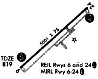
| A81-APT | ACTVT REIL RWY 06 & 24; PAPI RWY 06 & 24; MIRL RWY 06/24 - CTAF. |
Runways
Runway Summary
| Runways: | 06/24 |
| Longest Runway: | 06/24 is 5001 ft (1524 m) long |
| Runways with an Instrument Approach: | 06 |
RED Airport Runway Details
| Runway 06/24 | 5001 ft x 75 ft (1524 m x 23 m) | |
| Runway Length Source: | NGS as of 04/19/2007 | |
| Surface: | Asphalt - Good condition - No special surface treatment | |
| Runway Edge Lights: | Medium Intensity | |
Runway Weight Bearing Capacity (in thousands of pounds) |
||
| Single Wheel Landing Gear: | 60.0 | |
Runway 06 |
Runway 24 |
|
Elevation: |
815.5 | 809.8 |
Latitude: |
40-40-22.2762N | 40-40-54.8563N |
Longitude: |
077-38-01.0339W | 077-37-12.2275W |
|
Runway True Alignment: |
049 | 229 |
ILS Type: |
LOCALIZER | |
Glide Path Angle: |
4.0 degrees | 3.0 degrees |
Traffic Pattern: |
Left | Left |
Runway Markings Type: |
Nonprecision Instrument | Nonprecision Instrument |
Runway Markings Condition: |
Good | Good |
Object at End: |
TREES | |
Object Height: |
118 | |
Distance from End: |
2965 | |
Object Centerline Offset: |
163 ft. left of centerline | |
Visual Glide Slope Indicators: |
2-Light PAPI On Left Side Of Runway | 4-Light PAPI On Left Side Of Runway |
REIL: |
Yes | Yes |
Threshold Crossing Height: |
48 | 42 |
Services
Airframe Repair: |
None |
Powerplant Repair: |
None |
Bottled Oxygen: |
None |
Bulk Oxygen: |
None |
Fuel Available: |
100LL |
Landing Fees: |
No |
Parking: |
Tiedowns available |
Maps & Diagrams
RED Sectional
Flight Planning
at skyvector.com
at skyvector.com