Location
Latitude: |
48-56-32.7000N (48.942417) |
Longitude: |
097-14-26.4000W (-97.240667) |
Elevation: |
795.8 feet MSL (243 m MSL) |
Magnetic Variation: |
2.9 E (as of April 2024 from WMM2020 model) |
Time Zone: |
UTC -6.0 (Standard Time) UTC -5.0 (Daylight Savings Time) |
From City: |
01 N.M. S of Pembina, North Dakota |
Found On: |
Twin Cities Chart |
FAA Region: |
AGL |
Contacts
Manager: |
Publicly owned: |
| TERRY NORD 10597 OLD HWY 81 PEMBINA, ND 58271 701-331-4458 |
PEMBINA AIRPORT AUTH 10597 OLD HWY 81 PEMBINA, ND 58271 701-825-6615 |
Operations
Airport Status: |
Operational |
Facility Use: |
Public |
Type: |
Airport |
Activation Date: |
08/1938 |
Control tower: |
No |
Attendance (Months/Days/Hours): |
Months/Days/Hours ALL/ALL/ALL |
Boundary ARTCC: |
ZMP (Minneapolis) |
Responsible ARTCC: |
ZMP (Minneapolis) |
Lighting Schedule: |
SEE RMK |
Segmented Circle Indicator: |
No |
Traffic Pattern Altitude (MSL): |
1796 feet (547 m) |
NOTAMs Facility: |
GFK |
NOTAM-D Service: |
Yes |
International Airport of Entry: |
Yes |
Customs Landing Rights: |
No |
Military Landing Rights: |
Yes |
Civil/Military Joint Use: |
No |
Based Aircraft
| Single Engine: | 8 |
| Multi Engine: | 4 |
| Gliders: | 1 |
Annual Operations (as of 10/10/2023)
| Total Operations: | 3400 | |
| Air Taxi: | 200 | 5.9% |
| GA Local: | 2000 | 58.8% |
| GA Itinerant: | 1000 | 29.4% |
| Military Aircraft: | 200 | 5.9% |
Communications
| CTAF: | 122.800 |
| Unicom: | 122.800 |
- APCH/DEP SVC PRVDD BY MINNEAPOLIS ARTCC ON FREQS 132.15/269.6 (GRAND FORKS RCAG).
Fixed Based Operators (FBOs) & Fuel
(Click on a business for detail)
Please help us keep this information up to date. This is a FREE SERVICE just like everything else on Airport Guide! If you see that a business needs to be added, modified, or deleted please fill out our Update Form.
To add, modify, or delete a business click here.
Please help us keep this information up to date. This is a FREE SERVICE just like everything else on Airport Guide! If you see that a business needs to be added, modified, or deleted please fill out our Update Form.
Area Code: 701 |
| Business Name | Frequency | Phone | Fuel Grade |
|---|---|---|---|
| Nord Aviation
Update FBO info |
Unicom 122.8 | 825-6421 | 100LL, MOGAS |
Flight Service Stations
| Primary | Alternate | |
| FSS on Field: | N | |
| FSS Name (ID): | Grand Forks(GFK) | |
| Frequency: | ||
| Toll Free Phone: | 1-800-WX-BRIEF |
Instrument Procedures / Charts
FAA Terminal Procedures valid from 0901Z 03/21/24 to 0901Z 04/18/24.
There are various types of charts available for an airport. They are listed in the Page Type column. Here is a legend for those types:
APD - Airport Diagram
DP - Departure Procedure Charts
HOT - Hot Spots
IAP - Instrument Approach Procedure Charts
MIN - Minimums
STAR - Standard Terminal Arrival Charts
| Page Type | Page Name | Volume | Action Since Last Cycle |
|---|---|---|---|
| IAP | RNAV (GPS) RWY 33 | NC-1 | |
| MIN | TAKEOFF MINIMUMS | NC-1 |
Terminal Procedures are only available for airports in several countries with more being added all the time. If you are looking for a specific country's charts, please send an email to support(at)airportguide.com stating the country name. This will be used to prioritize the implementation.
Navigation Aids (Navaids) near PMB
| Dist (NM) | ID | Morse Code | Name | Type | Freq | True Hdg | Mag Hdg |
|---|---|---|---|---|---|---|---|
| 6.5 | HML | . . . . _ _ . _ . . | Humboldt | TACAN | 112.40 | 132 | 129 |
| 42.1 | LF | La Salle | NDB | 336 | 356 | 353 | |
| 49.7 | PFT | . _ _ . . . _ . _ | Piney Pinecreek | NDB | 342 | 85 | 83 |
| 53.3 | ZWW | Boine | NDB | 215 | 359 | 356 | |
| 53.6 | ZHT | Forks | NDB | 236 | 3 | 0 | |
| 57.6 | WG | Winnipeg | NDB | 248 | 355 | 352 | |
| 59.1 | YWG | _ . _ _ . _ _ _ _ . | Winnipeg | VORTAC | 115.50 | 0 | 357 |
| 59.3 | GFK | _ _ . . . _ . _ . _ | Grand Forks | VOR-DME | 114.30 | 177 | 174 |
| 59.5 | RDR | . _ . _ . . . _ . | Red River | TACAN | 116.40 | 186 | 183 |
| 61.2 | ROX | . _ . _ _ _ _ . . _ | Roseau | VOR-DME | 108.80 | 94 | 92 |
| 61.4 | ZWN | Downs | NDB | 201 | 357 | 354 | |
| 62.8 | ZWG | Stoney | NDB | 287 | 0 | 357 | |
| 65.2 | PG | Portage | NDB | 353 | 326 | 323 | |
| 65.8 | GF | _ _ . . . _ . | Hiser | NDB | 345 | 177 | 174 |
| 67.1 | TVF | _ . . . _ . . _ . | Thief River Falls | VOR-DME | 114.45 | 140 | 138 |
| 70.0 | YPG | Portage | VOR-DME | 114.60 | 325 | 322 | |
| 70.6 | CKN | _ . _ . _ . _ _ . | Crookston | NDB | 400 | 159 | 156 |
| 71.7 | BM | Balmoral | NDB | 375 | 357 | 354 | |
| 72.3 | HY | . . . . _ . _ _ | Harvi | NDB | 260 | 140 | 138 |
| 79.0 | SW | . . . . _ _ | Roadd | NDB | 360 | 92 | 90 |
Nearby Airports with Fuel
| Dist (NM) | Name (Airport IDs) | True Hdg | Mag Hdg | Fuel Grade |
|---|---|---|---|---|
| 18.1 | Cavalier Municipal Airport (2C8) |
238 | 235 | 100LL, Jet A |
| 26.1 | Walhalla Municipal Airport (96D) |
270 | 267 | 100LL |
| 32.7 | Hutson Field Airport (KGAF GAF) |
189 | 186 | 100LL, Jet A |
| 32.7 | Stephen Municipal Airport (D41) |
152 | 149 | 100LL |
| 49.7 | Piney Pinecreek Border Airport (48Y) |
85 | 83 | 100LL |
| 59.8 | Grand Forks International Airport (GFK KGFK GFK) |
177 | 174 | 100LL, Jet A |
| 61.1 | Roseau Municipal/Rudy Billberg Field Airport (ROX KROX ROX) |
94 | 92 | 100LL, Jet A |
| 67.3 | Thief River Falls Regional Airport (TVF KTVF TVF) |
141 | 139 | 100LL, Jet A, Jet A+ |
| 70.5 | Crookston Municipal/Kirkwood Field Airport (CKN KCKN CKN) |
159 | 157 | 100LL, Jet A |
| 74.6 | Warroad International Meml Airport (RRT KRRT RRT) |
89 | 88 | 100LL, Jet A |
| 82.8 | Devils Lake Regional Airport (DVL KDVL DVL) |
233 | 229 | 100LL, Jet A |
| 93.9 | Rolla Municipal/Leonard Krech Field Airport (06D) |
268 | 263 | 100LL, Jet A |
Notices to Airmen (NOTAMS)
Remarks
| A110-1 | CFM WINTER CONDS & SN REMOVAL BFR USE, CALL 701-331-4458 OR 701-825-6615. |
| A110-4 | RWY 15/33 TWY TO APRON MKD WITH REFLECTORS. |
| A110-7 | FOR CD CTC MINNEAPOLIS ARTCC AT 651-463-5588. |
| A110-8 | BIRDS & DEER ON & INVOF ARPT. |
| A13 | CHAIRMAN OF ARPT AUTH; MARK HATLOY 701-520-1841. |
| A17 | FOR SVCS CTC AMGR. |
| A31-15/33 | 500 FT STOPWAY NORTH END. |
| A70-FUEL-10 | 0LL FUEL SVC H24 PRVDD BY AMGR FUEL TRUCK. |
| A81-APT | ACTVT MIRL RWY 15/33; PAPI RWY 15 & 33 - CTAF. |
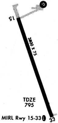
Runways
Runway Summary
| Runways: | 15/33 |
| Longest Runway: | 15/33 is 3798 ft (1158 m) long |
| Runways with an Instrument Approach: |
PMB Airport Runway Details
| Runway 15/33 | 3798 ft x 75 ft (1158 m x 23 m) | |
| Runway Length Source: | 3RD PARTY SURVEY as of 06/24/2014 | |
| Surface: | Asphalt - Good condition - No special surface treatment | |
| Runway Edge Lights: | Medium Intensity | |
Runway Weight Bearing Capacity (in thousands of pounds) |
||
| Single Wheel Landing Gear: | 12.5 | |
Runway 15 |
Runway 33 |
|
Elevation: |
794.7 | 795.5 |
Latitude: |
48-56-50.3345N | 48-56-15.1468N |
Longitude: |
097-14-36.1396W | 097-14-16.5890W |
|
Runway True Alignment: |
160 | 340 |
Glide Path Angle: |
3.0 degrees | 3.0 degrees |
Traffic Pattern: |
Left | Left |
Runway Markings Type: |
Nonprecision Instrument | Nonprecision Instrument |
Runway Markings Condition: |
Good | Good |
Visual Glide Slope Indicators: |
2-Light PAPI On Left Side Of Runway | 2-Light PAPI On Left Side Of Runway |
Threshold Crossing Height: |
26 | 26 |
Services
Airframe Repair: |
None |
Powerplant Repair: |
None |
Bottled Oxygen: |
None |
Bulk Oxygen: |
None |
Fuel Available: |
100LL, Jet A |
Landing Fees: |
No |
Parking: |
Hangars and tiedowns available |
Maps & Diagrams
PMB Sectional
Flight Planning
at skyvector.com
at skyvector.com