Location
Latitude: |
33-26-03.4000N (33.434278) |
Longitude: |
112-00-41.7000W (-112.011583) |
Elevation: |
1134.8 feet MSL (346 m MSL) |
Magnetic Variation: |
9.7 E (as of April 2024 from WMM2020 model) |
Time Zone: |
UTC -7.0 (Standard Time) UTC -7.0 (Daylight Savings Time) |
From City: |
03 N.M. E of Phoenix, Arizona |
Found On: |
Phoenix Chart |
FAA Region: |
AWP |
Contacts
Manager: |
Publicly owned: |
| CHAD R. MAKOVSKY 2485 E BUCKEYE RD PHOENIX, AZ 85034 602-273-3302 |
CITY OF PHOENIX 2485 E BUCKEYE RD PHOENIX, AZ 85034 602-273-3302 |
Operations
Airport Status: |
Operational |
Facility Use: |
Public |
Type: |
Airport |
Activation Date: |
04/1940 |
Control tower: |
Yes |
Attendance (Months/Days/Hours): |
Months/Days/Hours ALL/ALL/ALL |
Boundary ARTCC: |
ZAB (Albuquerque) |
Responsible ARTCC: |
ZAB (Albuquerque) |
Segmented Circle Indicator: |
No |
Traffic Pattern Altitude (MSL): |
2135 feet (651 m) |
NOTAMs Facility: |
PHX |
NOTAM-D Service: |
Yes |
International Airport of Entry: |
No |
Customs Landing Rights: |
Yes |
Military Landing Rights: |
Yes |
Civil/Military Joint Use: |
No |
Aircraft Rescue and Firefighting: |
Class I ARFF Index: D Air Carrier Service: Scheduled Certification Date: 05/1973 |
Based Aircraft
| Single Engine: | 14 |
| Multi Engine: | 10 |
| Jet Engine: | 27 |
| GA Helicopters: | 11 |
| Military Aircraft: | 8 |
Annual Operations (as of 01/31/2019)
| Total Operations: | 434901 | |
| Commercial: | 384714 | 88.5% |
| Air Taxi: | 27327 | 6.3% |
| GA Itinerant: | 20616 | 4.7% |
| Military Aircraft: | 2244 | 0.5% |
Communications
| Tower: | PHOENIX 118.7 ;RWY 08/26 120.9 ;RWY 07L/25R, 07R/25L 254.3 ;RWY 07L/25R, 07R/25L 278.8 ;RWY 08/26 Hrs: 24 |
| Clearance Del.: | 118.1 269.2 |
| Ground: | 119.75 ;NORTH 132.55 ;SOUTH 269.2 |
| Approach: | PHOENIX |
| Departure: | PHOENIX |
| ATIS: | 127.575 Hrs: 24 |
| ASOS: | (602-231-8557) |
| EMERG: | 243.0 |
- OPR 1200-0100Z MON-THURS, 1200-2200Z FRI, PPR REQ 48 HOURS PR NOTICE, CLSD WKDS AND HOL AMOPS DSN 853-9162, C 602-302-9162, 24 HR CP DSN 853-9071. LTD TRANS MAINT AND RON PRK BY PPR.CONTACT CP COPPER CONTROL 30 PRIOR TO LAND AND DEPART ON 311.0 TRAN ACFT USE SWIFT AVIATION WHEN ANG AFLD CLOSED 602-273-3770 ON 132.0. MIL ACFT. CAUTION-BIRD ACTIVITY WITHIN 10NM OF APT. BASH PHASE I JAN-FEB & JUN-SEP, BASH PHASE II MAR-JUN & OCT-DEC. RECORDS INDICATE MIG SEASONS AS MOST LIKLEY PERIODS OF SIGNIFICANTLY INCREASED LOCAL BIRD ACTIVITY. PHASE II IS ASSOCIATED WITH HEAVY BIRD ACTIVITY. BWC AVAIL UPON REQUEST. SEE AP1.
Fixed Based Operators (FBOs) & Fuel
(Click on a business for detail)
Please help us keep this information up to date. This is a FREE SERVICE just like everything else on Airport Guide! If you see that a business needs to be added, modified, or deleted please fill out our Update Form.
To add, modify, or delete a business click here.
Please help us keep this information up to date. This is a FREE SERVICE just like everything else on Airport Guide! If you see that a business needs to be added, modified, or deleted please fill out our Update Form.
Area Code: 602 |
| Business Name | Frequency | Phone | Fuel Grade |
|---|---|---|---|
| Arizona Piper
Update FBO info |
685-0235 office, 800-433-9617 parts | ||
| Cutter Aviation, Inc.
Update FBO info |
Unicom 122.85, Arinc 128.875 | 273-1237 | 100LL, Jet A |
| Executive Aircraft Terminal
Update FBO info |
Unicom 122.95 | 273-3395 | 100LL, Jet A |
| Sawyer Aviation
Update FBO info |
Unicom 132.0 | 273-3770 | 100LL, Jet A |
| Swift Aviation, Inc.
Update FBO info |
Unicom 122.95 | 273-7704 | 100LL, Jet A |
Flight Service Stations
| Primary | Alternate | |
| FSS on Field: | N | |
| FSS Name (ID): | Prescott(PRC) | |
| Frequency: | ||
| Toll Free Phone: | 1-800-WX-BRIEF |
Instrument Procedures / Charts
FAA Terminal Procedures valid from 0901Z 03/21/24 to 0901Z 04/18/24.
There are various types of charts available for an airport. They are listed in the Page Type column. Here is a legend for those types:
APD - Airport Diagram
DP - Departure Procedure Charts
HOT - Hot Spots
IAP - Instrument Approach Procedure Charts
MIN - Minimums
STAR - Standard Terminal Arrival Charts
Terminal Procedures are only available for airports in several countries with more being added all the time. If you are looking for a specific country's charts, please send an email to support(at)airportguide.com stating the country name. This will be used to prioritize the implementation.
Navigation Aids (Navaids) near PHX
| Dist (NM) | ID | Morse Code | Name | Type | Freq | True Hdg | Mag Hdg |
|---|---|---|---|---|---|---|---|
| 0.2 | PHX | . _ _ . . . . . _ . . _ | Phoenix | VOT | 109.00 | 69 | 59 |
| 2.1 | PXR | . _ _ . _ . . _ . _ . | Phoenix | VORTAC | 115.60 | 92 | 82 |
| 14.0 | FFZ | . . _ . . . _ . _ _ . . | Falcon Field | NDB | 281 | 83 | 73 |
| 14.3 | CHD | _ . _ . . . . . _ . . | Chandler | NDB | 407 | 134 | 124 |
| 19.5 | LUF | . _ . . . . _ . . _ . | Luke | TACAN | 113.00 | 288 | 278 |
| 19.7 | IWA | . . . _ _ . _ | Willie | VORTAC | 113.30 | 113 | 103 |
| 33.3 | TFD | _ . . _ . _ . . | Stanfield | VORTAC | 114.80 | 171 | 161 |
| 40.7 | BXK | _ . . . _ . . _ _ . _ | Buckeye | VORTAC | 110.60 | 271 | 261 |
| 43.9 | GBN | _ _ . _ . . . _ . | Gila Bend | VORTAC | 116.60 | 229 | 219 |
| 59.6 | PAN | . _ _ . . _ _ . | Payson | DME | 116.35 | 34 | 24 |
| 73.3 | AVQ | . _ . . . _ _ _ . _ | Marana | NDB | 245 | 146 | 137 |
| 75.8 | PRC | . _ _ . . _ . _ . _ . | Prescott | VOT | 110.00 | 344 | 334 |
| 79.6 | DRK | _ . . . _ . _ . _ | Drake | VORTAC | 114.10 | 343 | 333 |
| 88.0 | RBJ | . _ . _ . . . . _ _ _ | Robles | NDB | 220 | 157 | 148 |
| 88.8 | RYN | . _ . _ . _ _ _ . | Ryan | NDB | 338 | 150 | 141 |
| 95.4 | DMA | _ . . _ _ . _ | Davis Monthan | TACAN | 117.60 | 142 | 133 |
| 97.6 | TUS | _ . . _ . . . | Tucson | VORTAC | 116.00 | 145 | 136 |
Nearby Airports with Fuel
Notices to Airmen (NOTAMS)
Remarks
| A105 | NG HAS LMTD TRANSIENT MAINT & PARKING. RON BY PRIOR PERMISSION NG. |
| A110-12 | NOISE ABATEMENT PROCEDURES ARE IN AFFECT AT ALL TIMES. |
| A110-16 | TWY R AND PORTIONS OF TWYS S AND T DIRECTLY BELOW THE ATCT ARE NON VISIBLE AREAS FROM THE ATCT. |
| A110-19 | TWY R OVERHEAD TRAIN BRIDGE AT MIDPOINT PROVIDES 82FT-4 IN. CLEARANCE. |
| A110-23 | NO EXPERIMENTAL FLT OR GND DMSTRN ON ARPT WO PRIOR WRITTEN CONSENT FM THE AIRSIDE OPS. |
| A110-25 | NATL GUARD HAS LMTD TSNT MAINTENANCE AND PARKING RON BY PPR (602)302-9119. |
| A110-26 | PPR ACFT WITH WINGSPAN 215 FT OR GREATER (GROUP VI) CALL ARPT OPNS 602-272-2008 FOR FOLLOW-ME SERVICES WHILE TAXIING TO AND FROM RAMP AND RWYS. |
| A110-27 | PRACTICE INSTRUMENT APPROACHES, STOP & TAXI BACK LANDINGS, STOP & GO LANDINGS, TOUCH & GO LANDINGS ARE PROHIBITED. ALL OTHER FLIGHT TRAINING OPERATIONS PROHIBITED WO PRIOR WRITTEN APPROVAL (AIRSIDE OPS 602-272-2008). |
| A110-29 | NO ENG RUNS ON ARPT WO PRIOR COORDN WITH AIRSIDE OPS. NO ENG RUNS ON ARPT BETWEEN 2300L - 0500L. |
| A110-31 | INTERNATIONAL GATE USE RQS COORDN WITH ARPT OPS 48 HOURS PRIOR TO ARRIVAL. |
| A110-32 | INTERNATIONAL LANDING RIGHTS RQRS US CUSTOMS AND BORDER PROTECTION NOTIFICATION 48 HOURS PRIOR TO LANDING. |
| A110-33 | REVIEW HOT SPOT INFO ON AIRPORT DIAGRAM |
| A110-35 | RWY STATUS LGTS ARE IN OPN. |
| A110-36 | FOR GENERAL QUESTIONS CALL AIRPORT COMMUNICATIONS CENTER (602) 273-3302 |
| A110-37 | ASDE-X IN USE. OPERATE TRANSPONDERS WITH ALTITUDE REPORTING MODE AND ADS-B (IF EQUIPPED) ENABLED ON ALL AIRPORT SURFACES. |
| A110-39 | TWY F BTW TWY INT G2 AND G3 CLSD TO ACFT WITH WINGSPAN GREATER THAN 135 FT DUE TO FAA NAV EQUIPMENT. |
| A110-4 | FEE FOR ALL CHARTERS; TRAVEL CLUBS AND CERTAIN REVENUE PRODUCING ACFT. |
| A110-41 | TWYS C BTN S AND R, D BTN D2 AND D6, D3, D4,D5, D BTN D8 AND T, D9, H BTN TWY H4 AND TWY H7, H5, H6, H7 CLSD TO ACFT WINGSPAN MORE THAN 171 FT. |
| A110-42 | TWYS A BTN A3 AND A10, A4, A5, A6, A7, A8, A9, A12, F BTN G2 AND G3, D13 CLSD TO ACFT WINGSPAN OF MORE THAN 135FT. |
| A110-43 | TWY D BTN S AND D13, D10, D11, D12 CLSD TO ACFT WINGSPAN MORE THAN 118 FT. |
| A14 | AIRSIDE OPERATIONS SUPERINTENDENT, DUSTIN LOFTIS (602) 273-2072, AIRSIDE MANAGER, JODY SPRINGER (602) 273-3490. 24 HR AIRPORT DUTY MANAGER (602)273-3388. |
| A24 | OVERNIGHT PARKING FEE. |
| E147 | TPA: 1000'AGL LGT ACFT & NON-TURBOJETS; 1500'AGL HVY ACFT & TURBOJETS. |
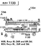
Runways
Runway Summary
| Runways: | 07L/25R 07R/25L 08/26 |
| Longest Runway: | 08/26 is 11489 ft (3502 m) long |
| Runways with an Instrument Approach: | 07L, 07R, 25L, 08, 26 |
PHX Airport Runway Details
| Runway 07L/25R | 10300 ft x 150 ft (3139 m x 46 m) | |
| Runway Length Source: | NGS as of 03/24/2004 | |
| Surface: | Concrete - Good condition - Saw-cut or plastic grooved | |
| Runway Pavement Class: | 70 /R/B/W/T | |
| Runway Edge Lights: | High Intensity | |
Runway Weight Bearing Capacity (in thousands of pounds) |
||
| Single Wheel Landing Gear: | 30.0 | |
| Dual Wheel Landing Gear: | 235.0 | |
| Dual Tandem Wheel Landing Gear: | 435.0 | |
| Dual Dual Tandem Wheel Landing Gear: | 940.0 | |
Runway 07L |
Runway 25R |
|
Elevation: |
1110.2 | 1134.0 |
Latitude: |
33-25-51.8081N | 33-25-51.7284N |
Longitude: |
112-01-37.5659W | 111-59-36.0429W |
|
Runway True Alignment: |
090 | 270 |
ILS Type: |
ILS/DME | |
Glide Path Angle: |
3.0 degrees | 3.0 degrees |
Traffic Pattern: |
Right | Left |
Runway Markings Type: |
Precision Instrument | Precision Instrument |
Runway Markings Condition: |
Good | Good |
Object at End: |
POLE | ANT |
Object Height: |
62 | 416 |
Distance from End: |
2958 | 17582 |
Object Centerline Offset: |
750 ft. right of centerline | 600 ft. left of centerline |
Visual Glide Slope Indicators: |
4-Light PAPI On Left Side Of Runway | 4-Light PAPI On Left Side Of Runway |
Runway Visual Range (RVR): |
Touchdown | Rollout |
Approach Light System: |
1,400 Foot Medium Intensity Approach Lighting System With Runway Alignment Indicator Lights | |
REIL: |
No | No |
Touchdown Lights: |
No | No |
Centerline Lights: |
No | No |
Threshold Crossing Height: |
73 | 70 |
Declared Distances |
||
Take Off Run Avbl. (TORA): |
10300 | 10300 |
Take Off Distance Avbl. (TODA): |
10300 | 10300 |
Actual Stop Dist. Avbl. (ASDA): |
10300 | 10300 |
Landing Dist. Avbl. (LDA): |
10300 | 10300 |
| Runway 07R/25L | 7800 ft x 150 ft (2377 m x 46 m) | |
| Runway Length Source: | NGS as of 03/24/2004 | |
| Surface: | Concrete - Good condition - Saw-cut or plastic grooved | |
| Runway Pavement Class: | 79 /R/B/W/T | |
| Runway Edge Lights: | High Intensity | |
Runway Weight Bearing Capacity (in thousands of pounds) |
||
| Single Wheel Landing Gear: | 30.0 | |
| Dual Wheel Landing Gear: | 200.0 | |
| Dual Tandem Wheel Landing Gear: | 400.0 | |
| Dual Dual Tandem Wheel Landing Gear: | 1010.0 | |
Runway 07R |
Runway 25L |
|
Elevation: |
1111.0 | 1126.3 |
Latitude: |
33-25-43.8923N | 33-25-43.8354N |
Longitude: |
112-01-37.5686W | 112-00-05.5412W |
|
Runway True Alignment: |
090 | 270 |
ILS Type: |
ILS/DME | ILS/DME |
Glide Path Angle: |
3.0 degrees | 3.0 degrees |
Runway Markings Type: |
Precision Instrument | Precision Instrument |
Runway Markings Condition: |
Good | Good |
Object at End: |
POLE | ANT |
Object Height: |
33 | 424 |
Object Marked/Lighted?: |
Lighted | |
Distance from End: |
900 | 20059 |
Object Centerline Offset: |
750 ft. right of centerline | 600 ft. left of centerline |
Visual Glide Slope Indicators: |
4-Light PAPI On Left Side Of Runway | 4-Light PAPI On Left Side Of Runway |
Approach Light System: |
1,400 Foot Medium Intensity Approach Lighting System With Runway Alignment Indicator Lights | 1,400 Foot Medium Intensity Approach Lighting System With Runway Alignment Indicator Lights |
Threshold Crossing Height: |
70 | 66 |
Declared Distances |
||
Take Off Run Avbl. (TORA): |
7800 | 7800 |
Take Off Distance Avbl. (TODA): |
7800 | 7800 |
Actual Stop Dist. Avbl. (ASDA): |
7800 | 7800 |
Landing Dist. Avbl. (LDA): |
7800 | 7800 |
| Runway 08/26 | 11489 ft x 150 ft (3502 m x 46 m) | |
| Runway Length Source: | NGS as of 03/24/2004 | |
| Surface: | Concrete - Good condition - Saw-cut or plastic grooved | |
| Runway Pavement Class: | 74 /R/B/W/T | |
| Runway Edge Lights: | High Intensity | |
Runway Weight Bearing Capacity (in thousands of pounds) |
||
| Single Wheel Landing Gear: | 30.0 | |
| Dual Wheel Landing Gear: | 200.0 | |
| Dual Tandem Wheel Landing Gear: | 455.0 | |
| Dual Dual Tandem Wheel Landing Gear: | 965.0 | |
Runway 08 |
Runway 26 |
|
Elevation: |
1111.1 | 1134.7 |
Latitude: |
33-26-27.0993N | 33-26-26.9643N |
Longitude: |
112-01-47.2570W | 111-59-31.6884W |
|
Runway True Alignment: |
090 | 270 |
ILS Type: |
ILS/DME | ILS/DME |
Glide Path Angle: |
3.0 degrees | 3.0 degrees |
Traffic Pattern: |
Left | Right |
Runway Markings Type: |
Precision Instrument | Precision Instrument |
Runway Markings Condition: |
Good | Good |
Object at End: |
BLDG | ROAD |
Object Height: |
66 | 9 |
Distance from End: |
3020 | 905 |
Object Centerline Offset: |
750 ft. right of centerline | 600 ft. left of centerline |
Visual Glide Slope Indicators: |
4-Light PAPI On Left Side Of Runway | 4-Light PAPI On Left Side Of Runway |
Approach Light System: |
1,400 Foot Medium Intensity Approach Lighting System With Sequenced Flashers | |
REIL: |
No | Yes |
Touchdown Lights: |
No | No |
Centerline Lights: |
No | No |
Threshold Crossing Height: |
69 | 71 |
Threshold Elevation: |
1112.5 | |
Displaced Threshold: |
898 | |
Threshold Latitude: |
33-26-27.0906N | |
Threshold Longitude: |
112-01-36.6574W | |
Declared Distances |
||
Take Off Run Avbl. (TORA): |
11489 | 11489 |
Take Off Distance Avbl. (TODA): |
11489 | 11489 |
Actual Stop Dist. Avbl. (ASDA): |
11489 | 11489 |
Landing Dist. Avbl. (LDA): |
10591 | 11489 |
Services
Fuel Available: |
100LL |
Landing Fees: |
No |
Parking: |
Tiedowns available |
Other Services: |
Fuel for emergency only |
Maps & Diagrams
PHX Sectional
Flight Planning
at skyvector.com
at skyvector.com