Location
Latitude: |
35-34-13.7000N (35.570472) |
Longitude: |
077-02-59.3000W (-77.049806) |
Elevation: |
37.4 feet MSL (11 m MSL) |
Magnetic Variation: |
10.2 W (as of April 2024 from WMM2020 model) |
Time Zone: |
UTC -5.0 (Standard Time) UTC -4.0 (Daylight Savings Time) |
From City: |
00 N.M. NE of Washington, North Carolina |
Found On: |
Charlotte Chart |
FAA Region: |
ASO |
Contacts
Manager: |
Publicly owned: |
| EARL MALPASS 200 AIRPORT ROAD WASHINGTON, NC 27889-9681 252-946-3900 |
CITY OF WASHINGTON PO BOX 1988 WASHINGTON, NC 27889 252-975-9302 |
Operations
Airport Status: |
Operational |
Facility Use: |
Public |
Type: |
Airport |
Activation Date: |
07/1942 |
Control tower: |
No |
Attendance (Months/Days/Hours): |
Months/Days/Hours ALL/MON-SAT/0800-1700 |
Boundary ARTCC: |
ZDC (Washington) |
Responsible ARTCC: |
ZDC (Washington) |
Lighting Schedule: |
SEE RMK |
Segmented Circle Indicator: |
No |
Traffic Pattern Altitude (MSL): |
1037 feet (316 m) |
NOTAMs Facility: |
OCW |
NOTAM-D Service: |
Yes |
International Airport of Entry: |
No |
Customs Landing Rights: |
No |
Military Landing Rights: |
Yes |
Civil/Military Joint Use: |
No |
Based Aircraft
| Single Engine: | 24 |
| Multi Engine: | 1 |
| GA Helicopters: | 1 |
Annual Operations (as of 06/07/2023)
| Total Operations: | 5600 | |
| Air Taxi: | 100 | 1.8% |
| GA Local: | 3000 | 53.6% |
| GA Itinerant: | 1500 | 26.8% |
| Military Aircraft: | 1000 | 17.9% |
Communications
| CTAF: | 122.700 |
| Unicom: | 122.700 |
| Approach: | CHERRY POINT 119.35 119.35 |
| Departure: | CHERRY POINT 119.35 119.35 |
| AWOS-3: | 120.175 (252-975-6133) |
Fixed Based Operators (FBOs) & Fuel
(Click on a business for detail)
Please help us keep this information up to date. This is a FREE SERVICE just like everything else on Airport Guide! If you see that a business needs to be added, modified, or deleted please fill out our Update Form.
To add, modify, or delete a business click here.
Please help us keep this information up to date. This is a FREE SERVICE just like everything else on Airport Guide! If you see that a business needs to be added, modified, or deleted please fill out our Update Form.
Area Code: 252 |
| Business Name | Frequency | Phone | Fuel Grade |
|---|
Flight Service Stations
| Primary | Alternate | |
| FSS on Field: | N | |
| FSS Name (ID): | Raleigh(RDU) | |
| Frequency: | ||
| Toll Free Phone: | 1-800-WX-BRIEF |
Instrument Procedures / Charts
FAA Terminal Procedures valid from 0901Z 03/21/24 to 0901Z 04/18/24.
There are various types of charts available for an airport. They are listed in the Page Type column. Here is a legend for those types:
APD - Airport Diagram
DP - Departure Procedure Charts
HOT - Hot Spots
IAP - Instrument Approach Procedure Charts
MIN - Minimums
STAR - Standard Terminal Arrival Charts
| Page Type | Page Name | Volume | Action Since Last Cycle |
|---|---|---|---|
| IAP | LOC RWY 05 | SE-2 | |
| IAP | RNAV (GPS) RWY 05 | SE-2 | |
| IAP | RNAV (GPS) RWY 23 | SE-2 | |
| IAP | RNAV (GPS) RWY 35 | SE-2 | |
| MIN | ALTERNATE MINIMUMS | SE-2 | |
| MIN | TAKEOFF MINIMUMS | SE-2 |
Terminal Procedures are only available for airports in several countries with more being added all the time. If you are looking for a specific country's charts, please send an email to support(at)airportguide.com stating the country name. This will be used to prioritize the implementation.
Navigation Aids (Navaids) near OCW
| Dist (NM) | ID | Morse Code | Name | Type | Freq | True Hdg | Mag Hdg |
|---|---|---|---|---|---|---|---|
| 4.6 | RNW | . _ . _ . . _ _ | Chocowinity | NDB | 388 | 217 | 227 |
| 16.8 | PGV | . _ _ . _ _ . . . . _ | Belvoir | FAN MARKER | 284 | 294 | |
| 17.7 | AQE | . _ _ _ . _ . | Alwood | NDB | 230 | 297 | 307 |
| 18.4 | MCZ | _ _ _ . _ . _ _ . . | Williamston | NDB | 336 | 340 | 350 |
| 27.6 | ISO | . . . . . _ _ _ | Kinston | VORTAC | 117.50 | 244 | 254 |
| 29.8 | EWN | . . _ _ _ . | New Bern | VOR-DME | 113.60 | 179 | 189 |
| 32.6 | ETC | . _ _ . _ . | Tarboro | NDB | 257 | 312 | 322 |
| 33.0 | EW | . . _ _ | Katfi | NDB | 362 | 182 | 192 |
| 36.0 | EDE | . _ . . . | Edenton | NDB | 265 | 40 | 50 |
| 37.3 | IS | . . . . . | Stals | NDB | 276 | 238 | 248 |
| 40.1 | TYI | _ _ . _ _ . . | Tar River | VORTAC | 117.80 | 307 | 317 |
| 41.0 | NKT | _ . _ . _ _ | Cherry Point | TACAN | 112.80 | 167 | 177 |
| 47.2 | GSB | _ _ . . . . _ . . . | Seymour Johnson | TACAN | 116.50 | 252 | 262 |
| 48.9 | CVI | _ . _ . . . . _ . . | Cofield | VORTAC | 114.60 | 10 | 20 |
| 52.0 | DKA | _ . . _ . _ . _ | Kenan | NDB | 332 | 235 | 245 |
| 53.8 | MRH | _ _ . _ . . . . . | Morehead | NDB | 269 | 159 | 169 |
| 55.2 | NCA | _ . _ . _ . . _ | New River | TACAN | 115.40 | 200 | 210 |
| 55.3 | LLW | . _ . . . _ . . . _ _ | Woodville | NDB | 254 | 41 | 51 |
| 58.7 | OUC | _ _ _ . . _ _ . _ . | Pamlico/Dcmsnd | NDB-DME | 404 | 117 | 127 |
| 58.8 | OA | _ _ _ . _ | Ellas | NDB | 261 | 213 | 223 |
Nearby Airports with Fuel
Notices to Airmen (NOTAMS)
Remarks
| A110-1 | TAXIWAYS NOT LIGHTED. |
| A110-3 | DEER & BIRDS ON & INVOF ARPT. |
| A110-4 | FOR CD CTC CHERRY POINT APCH AT 252-466-5960. |
| A110-5 | RWY 17/35 UNLGTD. |
| A110-6 | 120 FT+ TWR 3700 FT+ FM RWY 5 THLD ON CNTRLN. |
| A17 | FOR SVC AFTER HRS CALL 252-946-3900. |
| A17 1 | UNATNDD NEW YEARS DAY, EASTER, JULY 4TH, THANKSGIVING & CHRISTMAS. |
| A51-17 | DSPLCD THLD NOT MKD AT STATED DIST OF 500 FT BUT AT 1073 FT ON RWY. |
| A57-17 | APCH RATIO 18:1 TO DSPLCD THLD DUE 127 FT TREES 2597 FT FM DSPLCD THLD OFFSET 5 FT RIGHT OF CNTRLN. |
| A57-23 | APCH RATIO 17:1 TO DSPLCD THLD. |
| A70-FUEL-10 | 0LL FUEL 24 HR CREDIT CARD SVC AVBL. |
| A81-APT | MIRL RWY 05/23 PRESET ON LOW INTST; TO INCR INTST & ACTVT PAPIS RWY 05 & 23, AND REILS RWY 05 & 23 - CTAF. |
Runways
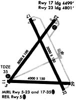
Runway Summary
| Runways: | 05/23 17/35 |
| Longest Runway: | 05/23 is 5000 ft (1524 m) long |
| Runways with an Instrument Approach: | 05 |
OCW Airport Runway Details
| Runway 05/23 | 5000 ft x 100 ft (1524 m x 30 m) | |
| Runway Length Source: | 3RD PARTY SURVEY as of 09/06/2007 | |
| Surface: | Asphalt - Excellent condition - No special surface treatment | |
| Runway Edge Lights: | Medium Intensity | |
Runway Weight Bearing Capacity (in thousands of pounds) |
||
| Single Wheel Landing Gear: | 30.0 | |
| Dual Wheel Landing Gear: | 38.0 | |
Runway 05 |
Runway 23 |
|
Elevation: |
29.6 | 37.4 |
Latitude: |
35-34-00.1664N | 35-34-39.7794N |
Longitude: |
077-03-23.0405W | 077-02-46.8106W |
|
Runway True Alignment: |
037 | 217 |
ILS Type: |
LOC/DME | |
Glide Path Angle: |
3.0 degrees | 3.8 degrees |
Traffic Pattern: |
Left | Left |
Runway Markings Type: |
Nonprecision Instrument | Nonprecision Instrument |
Runway Markings Condition: |
Good | Good |
Object at End: |
TREES | ROAD |
Object Height: |
43 | 17 |
Distance from End: |
665 | 348 |
Object Centerline Offset: |
253 ft. right of centerline | 0 ft. left and right of centerline |
Visual Glide Slope Indicators: |
2-Light PAPI On Left Side Of Runway | 2-Light PAPI On Left Side Of Runway |
REIL: |
Yes | Yes |
Threshold Crossing Height: |
46 | 45 |
Threshold Elevation: |
37.2 | |
Displaced Threshold: |
200 | |
Threshold Latitude: |
35-34-38.1974N | |
Threshold Longitude: |
077-02-48.2566W |
| Runway 17/35 | 5000 ft x 75 ft (1524 m x 23 m) | |
| Runway Length Source: | 3RD PARTY SURVEY as of 09/06/2007 | |
| Surface: | Asphalt - Excellent condition - No special surface treatment | |
Runway Weight Bearing Capacity (in thousands of pounds) |
||
| Single Wheel Landing Gear: | 22.0 | |
Runway 17 |
Runway 35 |
|
Elevation: |
37.0 | 33.6 |
Latitude: |
35-34-40.4168N | 35-33-55.5308N |
Longitude: |
077-03-06.0738W | 077-02-40.6890W |
|
Runway True Alignment: |
155 | 335 |
Glide Path Angle: |
0.0 degrees | 0.0 degrees |
Traffic Pattern: |
Left | Left |
Runway Markings Type: |
Nonprecision Instrument | Nonprecision Instrument |
Runway Markings Condition: |
Fair | Fair |
Object at End: |
POLE | TREES |
Object Height: |
39 | 16 |
Distance from End: |
325 | 501 |
Object Centerline Offset: |
253 ft. right of centerline | 0 ft. left and right of centerline |
Threshold Elevation: |
36.3 | |
Displaced Threshold: |
500 | |
Threshold Latitude: |
35-34-35.9328N | |
Threshold Longitude: |
077-03-03.5333W |
Services
Airframe Repair: |
Major |
Powerplant Repair: |
Major |
Bottled Oxygen: |
None |
Bulk Oxygen: |
None |
Fuel Available: |
100LL, Jet A-1+ |
Landing Fees: |
No |
Parking: |
Tiedowns available |
Maps & Diagrams
OCW Sectional
Flight Planning
at skyvector.com
at skyvector.com