Location
Latitude: |
39-10-44.4000N (39.179) |
Longitude: |
121-59-36.0000W (-121.993333) |
Elevation: |
49.0 feet MSL (15 m MSL) |
Magnetic Variation: |
13.3 E (as of April 2024 from WMM2020 model) |
Time Zone: |
UTC -8.0 (Standard Time) UTC -7.0 (Daylight Savings Time) |
From City: |
03 N.M. S of Colusa, California |
Found On: |
San Francisco Chart |
FAA Region: |
AWP |
Contacts
Manager: |
Publicly owned: |
| MICHAEL AZEVEDO 1215 MARKET ST, SUITE F COLUSA, CA 95932-3246 530-682-2612 |
COUNTY OF COLUSA COUNTY COURTHOUSE COLUSA, CA 95932 530-458-0466 |
Operations
Airport Status: |
Operational |
Facility Use: |
Public |
Type: |
Airport |
Activation Date: |
08/1962 |
Control tower: |
No |
Attendance (Months/Days/Hours): |
Months/Days/Hours ALL/ALL/DAWN-DUSK |
Boundary ARTCC: |
ZOA (Oakland) |
Responsible ARTCC: |
ZOA (Oakland) |
Lighting Schedule: |
SEE RMK |
Segmented Circle Indicator: |
Yes |
Traffic Pattern Altitude (MSL): |
1049 feet (320 m) |
NOTAMs Facility: |
RIU |
NOTAM-D Service: |
Yes |
International Airport of Entry: |
No |
Customs Landing Rights: |
No |
Military Landing Rights: |
Yes |
Civil/Military Joint Use: |
No |
Based Aircraft
| Single Engine: | 37 |
Annual Operations (as of 12/31/2021)
| Total Operations: | 28000 | |
| Air Taxi: | 100 | 0.4% |
| GA Local: | 21500 | 76.8% |
| GA Itinerant: | 6400 | 22.9% |
Communications
| CTAF: | 122.800 |
| Unicom: | 122.800 |
- APCH/DEP CTL SVC PRVDD BY OAKLAND ARTCC (ZOA) ON FREQS 132.2/350.3 (RED BLUFF RCAG).
Fixed Based Operators (FBOs) & Fuel
(Click on a business for detail)
Please help us keep this information up to date. This is a FREE SERVICE just like everything else on Airport Guide! If you see that a business needs to be added, modified, or deleted please fill out our Update Form.
To add, modify, or delete a business click here.
Please help us keep this information up to date. This is a FREE SERVICE just like everything else on Airport Guide! If you see that a business needs to be added, modified, or deleted please fill out our Update Form.
Area Code: 530 |
| Business Name | Frequency | Phone | Fuel Grade |
|---|---|---|---|
| Aerotech
Update FBO info |
458-5325 | ||
| Colusa County Airport
Update FBO info |
Unicom 122.8 | 458-2393 | 100LL |

|
Chevron |
100LL - 2.16 USD per gallon on 9/9/01 |
Pumps requiring line service |
| Huttman Aircraft Maintenance
Update FBO info |
458-4232 |
Flight Service Stations
| Primary | Alternate | |
| FSS on Field: | N | |
| FSS Name (ID): | Rancho Murieta(RIU) | |
| Frequency: | ||
| Toll Free Phone: | 1-800-WX-BRIEF |
Instrument Procedures / Charts
FAA Terminal Procedures valid from 0901Z 03/21/24 to 0901Z 04/18/24.
There are various types of charts available for an airport. They are listed in the Page Type column. Here is a legend for those types:
APD - Airport Diagram
DP - Departure Procedure Charts
HOT - Hot Spots
IAP - Instrument Approach Procedure Charts
MIN - Minimums
STAR - Standard Terminal Arrival Charts
| Page Type | Page Name | Volume | Action Since Last Cycle |
|---|---|---|---|
| IAP | RNAV (GPS) RWY 31 | SW-2 | |
| IAP | RNAV (GPS)-B | SW-2 | |
| IAP | VOR-A | SW-2 | |
| MIN | TAKEOFF MINIMUMS | SW-2 |
Terminal Procedures are only available for airports in several countries with more being added all the time. If you are looking for a specific country's charts, please send an email to support(at)airportguide.com stating the country name. This will be used to prioritize the implementation.
Navigation Aids (Navaids) near O08
| Dist (NM) | ID | Morse Code | Name | Type | Freq | True Hdg | Mag Hdg |
|---|---|---|---|---|---|---|---|
| 6.7 | ILA | . . . _ . . . _ | Williams | VORTAC | 114.40 | 193 | 180 |
| 13.5 | MXW | _ _ _ . . _ . _ _ | Maxwell | VORTAC | 110.00 | 308 | 295 |
| 17.8 | MY | _ _ _ . _ _ | Halow | NDB | 222 | 91 | 78 |
| 20.1 | MYV | _ _ _ . _ _ . . . _ | Marysville | VOR-DME | 110.80 | 103 | 90 |
| 25.8 | BAB | _ . . . . _ _ . . . | Beale | TACAN | 108.60 | 95 | 82 |
| 34.8 | SMF | . . . _ _ . . _ . | Sacramento Intl | VOT | 111.40 | 147 | 134 |
| 37.3 | CIC | _ . _ . . . _ . _ . | Chico | VOR-DME | 109.80 | 10 | 357 |
| 41.2 | MCC | _ _ _ . _ . _ . _ . | Mc Clellan | VOR-DME | 109.20 | 137 | 124 |
| 46.4 | SAC | . . . . _ _ . _ . | Sacramento Executive | VOT | 111.40 | 149 | 136 |
| 48.7 | SAC | . . . . _ _ . _ . | Sacramento | VORTAC | 115.20 | 154 | 141 |
| 50.8 | TZZ | _ _ _ . . _ _ . . | Travis | VOR | 116.40 | 170 | 157 |
| 55.5 | STS | . . . _ . . . | Santa Rosa | DME | 116.15 | 223 | 210 |
| 56.0 | SUU | . . . . . _ . . _ | Travis | TACAN | 116.60 | 177 | 164 |
| 56.3 | RBL | . _ . _ . . . . _ . . | Red Bluff | VORTAC | 115.70 | 348 | 335 |
| 57.2 | PBT | . _ _ . _ . . . _ | Proberta | NDB | 338 | 348 | 335 |
| 58.3 | UK | . . _ _ . _ | Kearn | NDB | 371 | 276 | 263 |
| 60.1 | ENI | . _ . . . | Mendocino | VORTAC | 112.30 | 263 | 250 |
| 62.6 | SGD | . . . _ _ . _ . . | Scaggs Island | VORTAC | 112.10 | 196 | 183 |
| 64.1 | HNW | . . . . _ . . _ _ | Hangtown | VOR-DME | 115.50 | 114 | 101 |
| 68.0 | CC | _ . _ . _ . _ . | Kanan | NDB | 335 | 181 | 168 |
Nearby Airports with Fuel
Notices to Airmen (NOTAMS)
Remarks
| A110-1 | BE ALERT TO BLDG 120 FT AGL 1000 FT WEST. |
| A110-2 | (E81) RWY EXIT LGTS ONLY. |
| A110-3 | BIRDS ON AND IN VICINITY OF AIRPORT |
| A110-4 | FOR CD CTC OAKLAND ARTCC AT 510-745-3380. |
| A14 | COUNTY PUB WORKS DIR. ARPT MGR 530-682-2612. |
| A70-FUEL-10 | 0LL FUEL AVBL BY CREDIT CARD 24/7 |
| A81-APT | ACTVT MIRL RY 13/31 - CTAF. |
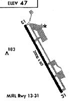
Runways
Runway Summary
| Runways: | 13/31 |
| Longest Runway: | 13/31 is 3034 ft (925 m) long |
| Runways with an Instrument Approach: |
O08 Airport Runway Details
| Runway 13/31 | 3034 ft x 59 ft (925 m x 18 m) | |
| Runway Length Source: | 3RD PARTY SURVEY as of 05/12/2016 | |
| Surface: | Asphalt - Good condition - No special surface treatment | |
| Runway Edge Lights: | Medium Intensity | |
Runway Weight Bearing Capacity (in thousands of pounds) |
||
| Single Wheel Landing Gear: | 10.0 | |
Runway 13 |
Runway 31 |
|
Elevation: |
48.8 | 46.8 |
Latitude: |
39-10-57.5012N | 39-10-31.3040N |
Longitude: |
121-59-45.3897W | 121-59-26.6474W |
|
Runway True Alignment: |
151 | 331 |
Glide Path Angle: |
3.0 degrees | 3.0 degrees |
Traffic Pattern: |
Right | |
Runway Markings Type: |
Nonprecision Instrument | Nonprecision Instrument |
Runway Markings Condition: |
Good | Good |
Object at End: |
ROAD | |
Object Height: |
15 | |
Distance from End: |
450 | |
Object Centerline Offset: |
100 ft. left of centerline | |
Visual Glide Slope Indicators: |
2-Light PAPI On Left Side Of Runway | 2-Light PAPI On Left Side Of Runway |
REIL: |
No | No |
Touchdown Lights: |
No | No |
Centerline Lights: |
No | No |
Threshold Crossing Height: |
25 | 43 |
Services
Airframe Repair: |
Major |
Powerplant Repair: |
Major |
Bottled Oxygen: |
High Pressure / Low Pressure |
Fuel Available: |
100LL |
Landing Fees: |
No |
Parking: |
Tiedowns available |
Maps & Diagrams
O08 Sectional
Flight Planning
at skyvector.com
at skyvector.com