Location
Latitude: |
41-31-56.7831N (41.53244) |
Longitude: |
071-16-53.5582W (-71.281544) |
Elevation: |
171.8 feet MSL (52 m MSL) |
Magnetic Variation: |
13.9 W (as of April 2024 from WMM2020 model) |
Time Zone: |
UTC -5.0 (Standard Time) UTC -4.0 (Daylight Savings Time) |
From City: |
02 N.M. NE of Newport, Rhode Island |
Found On: |
New York Chart |
FAA Region: |
ANE |
Contacts
Manager: |
Publicly owned: |
| IFTIKHAR AHMAD RHODE ISLAND AIRPORT CORP, 2000 POST RD WARWICK, RI 02886 401-691-2000 |
STATE OF RHODE ISLAND RHODE ISLAND AIRPORT CORPORATION, 2000 POST RD WARWICK, RI 02886 401-691-2000 |
Operations
Airport Status: |
Operational |
Facility Use: |
Public |
Type: |
Airport |
Activation Date: |
01/1947 |
Control tower: |
No |
Attendance (Months/Days/Hours): |
Months/Days/Hours MAY-SEP/SUN-SAT/0800-1800 |
Boundary ARTCC: |
ZBW (Boston) |
Responsible ARTCC: |
ZBW (Boston) |
Lighting Schedule: |
SEE RMK |
Segmented Circle Indicator: |
Yes |
Traffic Pattern Altitude (MSL): |
1172 feet (357 m) |
NOTAMs Facility: |
UUU |
NOTAM-D Service: |
Yes |
International Airport of Entry: |
No |
Customs Landing Rights: |
Yes |
Military Landing Rights: |
Yes |
Civil/Military Joint Use: |
No |
Based Aircraft
| Single Engine: | 10 |
Annual Operations (as of 07/31/2023)
| Total Operations: | 23181 | |
| Air Taxi: | 804 | 3.5% |
| GA Local: | 21367 | 92.2% |
| GA Itinerant: | 899 | 3.9% |
| Military Aircraft: | 111 | 0.5% |
Communications
| CTAF: | 123.050 |
| Unicom: | 123.050 |
| Approach: | PROVIDENCE BOSTON ARTCC |
| Departure: | PROVIDENCE BOSTON ARTCC |
| ASOS: | 132.075 (401-846-5910) |
- APCH/DEP SVC PRVDD BY BOSTON ARTCC ON FREQS 124.85/307.9 (WOODSTOCK RCAG) WHEN PROVIDENCE APCH CTL CLSD.
Fixed Based Operators (FBOs) & Fuel
(Click on a business for detail)
Please help us keep this information up to date. This is a FREE SERVICE just like everything else on Airport Guide! If you see that a business needs to be added, modified, or deleted please fill out our Update Form.
To add, modify, or delete a business click here.
Please help us keep this information up to date. This is a FREE SERVICE just like everything else on Airport Guide! If you see that a business needs to be added, modified, or deleted please fill out our Update Form.
Area Code: 401 |
| Business Name | Frequency | Phone | Fuel Grade |
|---|---|---|---|
| Newport Limousine, LLC
Website Update FBO info |
401-846-3500, cell phone 401-862-4855 |
Flight Service Stations
| Primary | Alternate | |
| FSS on Field: | N | |
| FSS Name (ID): | Bridgeport(BDR) | |
| Frequency: | ||
| Toll Free Phone: | 1-800-WX-BRIEF |
Instrument Procedures / Charts
FAA Terminal Procedures valid from 0901Z 03/21/24 to 0901Z 04/18/24.
There are various types of charts available for an airport. They are listed in the Page Type column. Here is a legend for those types:
APD - Airport Diagram
DP - Departure Procedure Charts
HOT - Hot Spots
IAP - Instrument Approach Procedure Charts
MIN - Minimums
STAR - Standard Terminal Arrival Charts
| Page Type | Page Name | Volume | Action Since Last Cycle |
|---|---|---|---|
| IAP | LOC RWY 22 | NE-1 | Changed |
| IAP | RNAV (GPS) RWY 16 | NE-1 | Changed |
| IAP | VOR/DME RWY 16 | NE-1 | Changed |
| MIN | ALTERNATE MINIMUMS | NE-1 | |
| MIN | TAKEOFF MINIMUMS | NE-1 | |
| STAR | WIPOR THREE (RNAV) | NE-1 |
Terminal Procedures are only available for airports in several countries with more being added all the time. If you are looking for a specific country's charts, please send an email to support(at)airportguide.com stating the country name. This will be used to prioritize the implementation.
Navigation Aids (Navaids) near NPT
| Dist (NM) | ID | Morse Code | Name | Type | Freq | True Hdg | Mag Hdg |
|---|---|---|---|---|---|---|---|
| 13.2 | PVD | . _ _ . . . . _ _ . . | Providence | VOT | 108.20 | 330 | 344 |
| 13.3 | PVD | . _ _ . . . . _ _ . . | Providence | VOR-DME | 115.60 | 330 | 344 |
| 17.0 | AR | . _ . _ . | Armin | NDB | 356 | 349 | 363 |
| 23.8 | TAN | _ . _ _ . | Taunton | NDB | 227 | 29 | 43 |
| 25.6 | SEY | . . . . _ . _ _ | Sandy Point | VOR-DME | 117.80 | 211 | 225 |
| 28.5 | IHM | . . . . . . _ _ | Mansfield | NDB | 220 | 7 | 21 |
| 31.2 | MVY | _ _ . . . _ _ . _ _ | Marthas Vineyard | VOR-DME | 114.50 | 104 | 118 |
| 32.3 | ORW | _ _ _ . _ . . _ _ | Norwich | VOR-DME | 110.00 | 272 | 286 |
| 35.3 | FMH | . . _ . _ _ . . . . | Otis | TACAN | 115.80 | 77 | 91 |
| 35.8 | PUT | . _ _ . . . _ _ | Putnam | VOR-DME | 117.40 | 315 | 329 |
| 35.9 | OW | _ _ _ . _ _ | Stoge | NDB | 397 | 10 | 24 |
| 36.7 | GON | _ _ . _ _ _ _ . | Groton | VOR-DME | 110.85 | 250 | 264 |
| 36.8 | GON | _ _ . _ _ _ _ . | Groton | VOT | 110.25 | 250 | 264 |
| 39.5 | FM | . . _ . _ _ | Bomde | NDB | 362 | 72 | 86 |
| 43.4 | IMR | . . _ _ . _ . | Marshfield | NDB | 368 | 38 | 52 |
| 51.2 | BOS | _ . . . _ _ _ . . . | Boston | VOT | 111.00 | 14 | 28 |
| 51.2 | BOS | _ . . . _ _ _ . . . | Boston | VOR-DME | 112.70 | 14 | 28 |
| 51.3 | ORH | _ _ _ . _ . . . . . | Worcester | VOT | 108.20 | 329 | 343 |
| 55.6 | SKR | . . . _ . _ . _ . | Shaker Hill | NDB | 251 | 4 | 18 |
| 56.0 | BED | _ . . . . _ . . | Bedford | VOT | 110.00 | 359 | 373 |
Nearby Airports with Fuel
Notices to Airmen (NOTAMS)
Remarks
| A110-1 | DEER & BIRDS ON & INVOF ARPT. |
| A110-10 | RWY 04 DSGND CALM WIND RWY. |
| A110-2 | RWY CONDS MAY NOT BE MNT OR RPRTD WHEN ARPT IS UNATNDD. ARPT UNATNDD 1800-0700 DLY & SUN-MON. CTC RIAC OPS AT 401-691-2265. |
| A110-3 | APRT LCTD IN NOISE SENSITIVE AREA. POPULATED AREAS TO THE S & N. NOISE ABATEMENT PROCS IN EFCT. CTC AMGR 401-691-2265 FOR MORE INFO. |
| A110-4 | PPR FOR JET ACFT. |
| A110-5 | HELS REQSTD TO AVOID MAIN TRML RAMP FOR PRKG OR LDG. PLS CTC AMGR. |
| A110-6 | SEASONAL BIRD ACTVTY AER 34, CTC AMGR FOR DTLS 401-691-2265. |
| A110-7 | 24 HRS ADVN NOTICE RQRD FOR ALL JET A SVCS AFT POSTED BUS HRS. |
| A110-8 | FOR CD WHEN APCH CLSD CTC BOSTON ARTCC AT 603-879-6859. |
| A110-9 | NMRS UNLGTD OBSTNS UP TO 150 FT AGL SRNDG AIRFIELD. |
| A24 | OVNGT PRKG FEE. LDG FEE COML & NON RHODE ISLAND REG ACFT. |
| A33-04/22 | NMRS CRACKS FULL WID & LEN. |
| A33-16/34 | NMRS CRACKS FULL WID & LEN. |
| A43-04 | OTS UFN. |
| A51-04 | TMPRY DTHR 499 FT. |
| A57-04 | 22:1 FM TMPRY DTHR. |
| A57-34 | 29:1 FM DTHR. |
| A58-04 | 10 FT TREES, 160 FT FM THR, 120 FT R; 20 FT TREES, 100 FT FM THR, 200 FT L. |
| A58-16 | 10 FT FENCE/TREES 50 FT FM THR, 220 FT L; 10 FT TREES, 190 FT FM THR, 240 FT R. |
| A70-FUEL-10 | 0LL FUEL AVBL 24 HRS BY CREDIT CARD. |
| A81-APT | ACTVT REIL RWY 22; PAPI RWY 22, VASI RWY 4 & 16; MIRL RWY 04/22 & 16/34; TWY A, B, C & RAMP AREA - CTAF. |
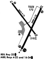
Runways
Runway Summary
| Runways: | 04/22 16/34 |
| Longest Runway: | 04/22 is 2999 ft (914 m) long |
| Runways with an Instrument Approach: | 22 |
NPT Airport Runway Details
| Runway 04/22 | 2999 ft x 75 ft (914 m x 23 m) | |
| Runway Length Source: | FAA as of 05/27/1991 | |
| Surface: | Asphalt - Poor condition - No special surface treatment | |
| Runway Edge Lights: | Medium Intensity | |
Runway Weight Bearing Capacity (in thousands of pounds) |
||
| Single Wheel Landing Gear: | 30.0 | |
Runway 04 |
Runway 22 |
|
Elevation: |
148.3 | 171.8 |
Latitude: |
41-31-39.2985N | 41-32-06.4015N |
Longitude: |
071-16-58.9974W | 071-16-43.0766W |
|
Runway True Alignment: |
024 | 204 |
ILS Type: |
LOC/DME | |
Glide Path Angle: |
4.0 degrees | 4.0 degrees |
Traffic Pattern: |
Left | Left |
Runway Markings Type: |
Basic | Nonprecision Instrument |
Runway Markings Condition: |
Fair | Fair |
Object at End: |
TREES | TREES |
Object Height: |
75 | 38 |
Distance from End: |
1250 | 750 |
Object Centerline Offset: |
20 ft. right of centerline | 250 ft. left of centerline |
Visual Glide Slope Indicators: |
4-Box VASI On Left Side Of Runway | 4-Light PAPI On Left Side Of Runway |
REIL: |
No | Yes |
Threshold Crossing Height: |
51 | 30 |
| Runway 16/34 | 2623 ft x 75 ft (799 m x 23 m) | |
| Runway Length Source: | FAA as of 05/27/1991 | |
| Surface: | Asphalt - Poor condition - No special surface treatment | |
| Runway Edge Lights: | Medium Intensity | |
Runway Weight Bearing Capacity (in thousands of pounds) |
||
| Single Wheel Landing Gear: | 30.0 | |
Runway 16 |
Runway 34 |
|
Elevation: |
146.3 | 162.2 |
Latitude: |
41-32-11.7013N | 41-31-50.8585N |
Longitude: |
071-17-06.6887W | 071-16-46.1928W |
|
Runway True Alignment: |
144 | 324 |
Glide Path Angle: |
3.8 degrees | 0.0 degrees |
Traffic Pattern: |
Left | Left |
Runway Markings Type: |
Basic | Basic |
Runway Markings Condition: |
Fair | Fair |
Object at End: |
TREES | TREES |
Object Height: |
37 | 37 |
Distance from End: |
525 | 900 |
Object Centerline Offset: |
20 ft. right of centerline | 250 ft. left of centerline |
Visual Glide Slope Indicators: |
4-Box VASI On Left Side Of Runway | |
REIL: |
No | No |
Threshold Crossing Height: |
40 | |
Threshold Elevation: |
162.0 | |
Displaced Threshold: |
250 | |
Threshold Latitude: |
41-31-52.8450N | |
Threshold Longitude: |
071-16-48.1461W |
Services
Airframe Repair: |
Major |
Powerplant Repair: |
Major |
Bottled Oxygen: |
None |
Bulk Oxygen: |
None |
Fuel Available: |
100LL |
Landing Fees: |
No |
Parking: |
Tiedowns available |
Maps & Diagrams
NPT Sectional
Flight Planning
at skyvector.com
at skyvector.com