Location
Latitude: |
43-08-23.5649N (43.139879) |
Longitude: |
089-20-15.0161W (-89.337504) |
Elevation: |
886.6 feet MSL (270 m MSL) |
Magnetic Variation: |
3 W (as of April 2024 from WMM2020 model) |
Time Zone: |
UTC -6.0 (Standard Time) UTC -5.0 (Daylight Savings Time) |
From City: |
05 N.M. NE of Madison, Wisconsin |
Found On: |
Chicago Chart |
FAA Region: |
AGL |
Contacts
Manager: |
Publicly owned: |
| KIMBERLY S. JONES 4000 INTERNATIONAL LANE MADISON, WI 53704 608-246-3380 |
DANE COUNTY 4000 INTERNATIONAL LANE MADISON, WI 53704 608-246-3390 |
Operations
Airport Status: |
Operational |
Facility Use: |
Public |
Type: |
Airport |
Activation Date: |
09/1937 |
Control tower: |
Yes |
Attendance (Months/Days/Hours): |
Months/Days/Hours ALL/ALL/ALL |
Boundary ARTCC: |
ZAU (Chicago) |
Responsible ARTCC: |
ZAU (Chicago) |
Lighting Schedule: |
SEE RMK |
Segmented Circle Indicator: |
No |
Traffic Pattern Altitude (MSL): |
1887 feet (575 m) |
NOTAMs Facility: |
MSN |
NOTAM-D Service: |
Yes |
International Airport of Entry: |
No |
Customs Landing Rights: |
No |
Military Landing Rights: |
Yes |
Civil/Military Joint Use: |
No |
Aircraft Rescue and Firefighting: |
Class I ARFF Index: C Air Carrier Service: Scheduled Certification Date: 05/1973 |
Based Aircraft
| Single Engine: | 92 |
| Multi Engine: | 7 |
| Jet Engine: | 28 |
| GA Helicopters: | 1 |
| Military Aircraft: | 35 |
Annual Operations (as of 12/31/2022)
| Total Operations: | 76218 | |
| Commercial: | 20505 | 26.9% |
| Air Taxi: | 8614 | 11.3% |
| GA Local: | 15523 | 20.4% |
| GA Itinerant: | 27694 | 36.3% |
| Military Aircraft: | 3882 | 5.1% |
Communications
| CTAF: | 119.300 |
| Unicom: | 122.950 |
| Tower: | MADISON 119.3 257.8 Hrs: 0600-2300 |
| Clearance Del.: | 121.625 |
| Ground: | 121.9 348.6 |
| Approach: | MADISON 120.1 ;EAST 135.45 ;WEST 343.7 ;WEST 350.3 ;EAST Hrs: 0600-2300 CHICAGO ARTCC Hrs: HOURS MADISON APCH CLSD |
| Departure: | MADISON 120.1 ;EAST 135.45 ;WEST 343.7 ;WEST 350.3 ;EAST Hrs: 0600-2300 CHICAGO ARTCC Hrs: HOURS MADISON APCH CLSD |
| ATIS: | 124.65 278.3 Hrs: 24 |
| ASOS: | (608-249-0615) |
| CLASS C: | 135.45 ;WEST |
| CLASS C: | 343.7 ;WEST |
| ANG OPS: | 138.175 |
| CLASS C: | 120.1 ;EAST |
| ANG OPS: | 238.2 |
| EMERG: | 121.5 |
| EMERG: | 243.0 |
| CLASS C: | 350.3 ;EAST |
| ANG OPS: | 40.8 |
| ANG OPS: | 123.4 |
| ANG OPS: | 299.9 |
- ARMY OPERATION CALL 'FIREFLY'. 0730-1600 LCL.
- APCH/DEP SVC PRVDD BY CHICAGO ARTCC ON FREQS 133.3/257.925 (LONE ROCK RCAG) & 135.45 WHEN MADISON APCH CTL CLSD.
- CALL MADISON OPS
- CALL MADISON OPS .
- CALL MADISON OPS
Fixed Based Operators (FBOs) & Fuel
(Click on a business for detail)
Please help us keep this information up to date. This is a FREE SERVICE just like everything else on Airport Guide! If you see that a business needs to be added, modified, or deleted please fill out our Update Form.
To add, modify, or delete a business click here.
Please help us keep this information up to date. This is a FREE SERVICE just like everything else on Airport Guide! If you see that a business needs to be added, modified, or deleted please fill out our Update Form.
Area Code: 608 |
| Business Name | Frequency | Phone | Fuel Grade |
|---|---|---|---|
| Wisconsin Aviation-Madison
Website Update FBO info |
Unicom 122.95 | 268-5003, 268-5006 Avionics | 100LL, Jet A |
Flight Service Stations
| Primary | Alternate | |
| FSS on Field: | N | |
| FSS Name (ID): | Green Bay(GRB) | |
| Frequency: | ||
| Toll Free Phone: | 1-800-WX-BRIEF |
Instrument Procedures / Charts
FAA Terminal Procedures valid from 0901Z 03/21/24 to 0901Z 04/18/24.
There are various types of charts available for an airport. They are listed in the Page Type column. Here is a legend for those types:
APD - Airport Diagram
DP - Departure Procedure Charts
HOT - Hot Spots
IAP - Instrument Approach Procedure Charts
MIN - Minimums
STAR - Standard Terminal Arrival Charts
| Page Type | Page Name | Volume | Action Since Last Cycle |
|---|---|---|---|
| APD | AIRPORT DIAGRAM | EC-3 | |
| HOT | HOT SPOT | EC-3 | |
| IAP | HI-TACAN RWY 18 | EC-3 | Changed |
| IAP | HI-TACAN RWY 36 | EC-3 | Changed |
| IAP | ILS OR LOC RWY 18 | EC-3 | |
| IAP | ILS OR LOC RWY 21 | EC-3 | |
| IAP | ILS OR LOC/DME RWY 36 | EC-3 | |
| IAP | ILS RWY 18 (SA CAT I - II) | EC-3 | |
| IAP | ILS RWY 36 (CAT II - III) | EC-3 | |
| IAP | ILS RWY 36 (SA CAT I) | EC-3 | |
| IAP | RNAV (GPS) RWY 03 | EC-3 | |
| IAP | RNAV (GPS) RWY 14 | EC-3 | |
| IAP | RNAV (GPS) RWY 18 | EC-3 | |
| IAP | RNAV (GPS) RWY 21 | EC-3 | |
| IAP | RNAV (GPS) RWY 32 | EC-3 | |
| IAP | RNAV (GPS) RWY 36 | EC-3 | |
| IAP | VOR RWY 14 | EC-3 | |
| IAP | VOR RWY 32 | EC-3 | |
| LAH | LAHSO | EC-3 | |
| MIN | ALTERNATE MINIMUMS | EC-3 | |
| MIN | TAKEOFF MINIMUMS | EC-3 |
Terminal Procedures are only available for airports in several countries with more being added all the time. If you are looking for a specific country's charts, please send an email to support(at)airportguide.com stating the country name. This will be used to prioritize the implementation.
Navigation Aids (Navaids) near MSN
| Dist (NM) | ID | Morse Code | Name | Type | Freq | True Hdg | Mag Hdg |
|---|---|---|---|---|---|---|---|
| 0.3 | MSN | _ _ . . . _ . | Madison | VORTAC | 108.60 | 341 | 344 |
| 4.6 | MS | _ _ . . . | Monah | NDB | 400 | 184 | 187 |
| 26.9 | RYV | . _ . _ . _ _ . . . _ | Rock River | NDB | 371 | 85 | 88 |
| 30.9 | DLL | _ . . . _ . . . _ . . | Dells | VORTAC | 117.00 | 323 | 326 |
| 32.7 | UNU | . . _ _ . . . _ | Juneau | NDB | 344 | 57 | 60 |
| 34.1 | JVL | . _ _ _ . . . _ . _ . . | Janesville | NDB | 375 | 157 | 160 |
| 36.0 | LNR | . _ . . _ . . _ . | Lone Rock | DME | 116.05 | 285 | 288 |
| 36.4 | JVL | . _ _ _ . . . _ . _ . . | Janesville | VOR-DME | 114.30 | 163 | 166 |
| 41.8 | MRJ | _ _ . _ . . _ _ _ | Mineral Point | NDB | 365 | 249 | 252 |
| 42.1 | LVV | . _ . . . . . _ . . . _ | Lake Lawn | NDB | 404 | 128 | 131 |
| 46.1 | BAE | _ . . . . _ . | Badger | VOR-DME | 116.40 | 91 | 94 |
| 52.9 | BUU | _ . . . . . _ . . _ | Burbun | DME | 114.5 | 120 | 123 |
| 53.3 | HBW | . . . . _ . . . . _ _ | Kickapoo | NDB | 251 | 305 | 308 |
| 55.2 | RFD | . _ . . . _ . _ . . | Rockford | DME | 110.8 | 173 | 176 |
| 55.6 | BJB | _ . . . . _ _ _ _ . . . | West Bend | VOR | 109.80 | 71 | 75 |
| 55.6 | OS | _ _ _ . . . | Pober | NDB | 395 | 37 | 40 |
| 57.0 | LJT | . _ . . . _ _ _ _ | Timmerman | DME | 115.65 | 91 | 95 |
| 58.5 | GM | _ _ . _ _ | Teels | NDB | 242 | 103 | 107 |
| 61.3 | OSH | _ _ _ . . . . . . . | Oshkosh | VORTAC | 116.75 | 33 | 36 |
| 62.4 | RF | . _ . . . _ . | Gilmy | NDB | 275 | 170 | 173 |
Nearby Airports with Fuel
Notices to Airmen (NOTAMS)
Remarks
| A110-18 | TWY F & G RSTRD TO MIL ACFT ONLY. |
| A110-2 | WEST RAMP RSTD TO AIR CARRIER ACFT ONLY. |
| A110-24 | MILITARY: ANG: PPR ALL ACT, CONTACT EMAIL: 115FW.PPR.ORG@US.AF.MIL. OPR HR 1200-2230Z++MON-THURS, DSN 724-8642/8436, C608 245-4642/4436. DSN 724-8580 H24, C608 245-4580 H24. |
| A110-25 | AVOID OVERFLIGHT OF YAHARA RIVER INVOF ARPT BLO 2000 FT AGL. |
| A110-28 | RW 14 & 18 APCH ENDS CLOSELY ALIGNED; VERIFY CORRECT RWY AND COMPASS HDG PRIOR TO DEP. |
| A110-29 | E RAMP BTN TWYS H AND M CLSD TO ACFT WITH WINGSPAN MORE THAN 118 FT. TWYS L1, L6, B5, & E & TWY H N OF RWY 14/32 CLSD TO ACFT WITH WINGSPAN MORE THAN 118 FT. E RAMP & TWYS B1, J & B N OF TWY M CLSD TO ACFT WITH WINGSPAN MORE THAN 150 FT. |
| A110-3 | NOISE ABATEMENT PROC IN EFCT: DEP ACFT UTILIZE RWY 03 & 36; ARR ACFT UTILIZE RWY 18 & 21. |
| A110-31 | ARNG: PPR, ARNG COPTER RQR SVC, CTC ARMY OPS, LTD TRAN SVC, OPR 1300-2200Z++ MON, TUE; 1300-0400Z++ WED-FRI, CLSD SAT, SUN DSN 745-8310, C608-301-8310. |
| A110-32 | PPR FOR HIGH RISK FLT TEST 608-246-3397. |
| A110-34 | ENGINE RUNUP RSTD TO NORTH HOLD BAY ONLY. |
| A110-35 | BARRICADES ALONG WEST EDGE OF SOUTH RAMP ADJ MIL RAMP. |
| A110-36 | WEST RAMP UNCONTROLLED; PUSHBACK IS AT PILOT'S DISCRETION. |
| A110-38 | SERVICE-FUEL: A++ (MIL) |
| A110-41 | RWY 18, 21, 36 BAK-14 ARRESTING CABLE FOR MIL USE ONLY AND RETRACTED WHEN NOT IN USE. |
| A110-42 | FOR CD CTC MADISON APP/DEP CON AT 608-249-8240. WHEN MADISON APCH CLSD, FOR CD CTC CHICAGO ARTCC AT 630-906-8921. |
| A110-43 | TWY F AND G RSTRD TO FIGHTER ACFT ONLY. |
| A110-5 | ACR & TURBO JET TRNG FLGTS PROHIBITED. |
| A110-7 | BIRDS ON & INVOF ARPT. |
| A43-18 | UNUSBL BYD 9 DEGS RIGHT OF CNTRLN. |
| A49-36 | RWY 36 ALSF2 OPRS AS SSALR WHEN TWR CLSD. |
| A57-03 | APCH RATIO 41:1 FM DSPLCD THR. |
| A57-18 | APCH RATIO 40:1 FM DSPLCD THR. |
| A70-FUEL-10 | 0LL AV FUEL REFUELING AVBL ON EAST OR SOUTH APRON ONLY. |
| A81-APT | ACTVT MALSR RWY 18 & 21; REIL RWY 03, 14 & 32; HIRL RWY 03/21, 14/32 & 18/36 - CTAF. WHEN ATCT CLSD HIRL RWY 18/36 PRESET ON LOW INTST, TO INCR INTST & ACTVT - CTAF. |
| E147 | MILITARY: OVHD TFC PAT ALT RSTRD TO 3500 FT MSL; RWY 18/36 L TURN. |
| E60-18 | BAK-14 BAK-12(B) (1900'). |
| E60-21 | BAK-14 BAK-12(B) (1620'). |
| E60-36 | BAK-14 BAK-12(B) (1750'). |
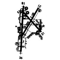
Runways
Runway Summary
| Runways: | 03/21 14/32 18/36 |
| Longest Runway: | 18/36 is 9006 ft (2745 m) long |
| Runways with an Instrument Approach: | 21, 18, 36 |
MSN Airport Runway Details
| Runway 03/21 | 7200 ft x 150 ft (2195 m x 46 m) | |
| Runway Length Source: | 3RD PARTY SURVEY as of 06/16/2011 | |
| Surface: | Concrete - Good condition - Saw-cut or plastic grooved | |
| Runway Pavement Class: | 95 /R/B/W/T | |
| Runway Edge Lights: | High Intensity | |
Runway Weight Bearing Capacity (in thousands of pounds) |
||
| Single Wheel Landing Gear: | 100.0 | |
| Dual Wheel Landing Gear: | 200.0 | |
| Dual Tandem Wheel Landing Gear: | 350.0 | |
Runway 03 |
Runway 21 |
|
Elevation: |
860.8 | 886.6 |
Latitude: |
43-07-59.8870N | 43-09-02.0891N |
Longitude: |
089-20-30.3262W | 089-19-43.2575W |
|
Runway True Alignment: |
029 | 209 |
ILS Type: |
ILS/DME | |
Glide Path Angle: |
3.0 degrees | 3.0 degrees |
Runway Markings Type: |
Precision Instrument | Precision Instrument |
Runway Markings Condition: |
Good | Good |
Arresting Device: |
BAK-14 | |
Object at End: |
TREES | ROAD |
Object Height: |
72 | 19 |
Distance from End: |
2760 | 2050 |
Object Centerline Offset: |
460 ft. left of centerline | 0 ft. left and right of centerline |
Visual Glide Slope Indicators: |
4-Light PAPI On Left Side Of Runway | 4-Light PAPI On Left Side Of Runway |
Approach Light System: |
1,400 Foot Medium Intensity Approach Lighting System With Runway Alignment Indicator Lights | |
REIL: |
Yes | |
Threshold Crossing Height: |
49 | 53 |
Threshold Elevation: |
859.7 | |
Displaced Threshold: |
431 | |
Threshold Latitude: |
43-08-03.5976N | |
Threshold Longitude: |
089-20-27.5165W | |
Declared Distances |
||
Take Off Run Avbl. (TORA): |
7200 | 6770 |
Take Off Distance Avbl. (TODA): |
7200 | 6770 |
Actual Stop Dist. Avbl. (ASDA): |
7200 | 7015 |
Landing Dist. Avbl. (LDA): |
6770 | 7015 |
| Runway 14/32 | 5846 ft x 150 ft (1782 m x 46 m) | |
| Runway Length Source: | 3RD PARTY SURVEY as of 06/16/2011 | |
| Surface: | Concrete - Good condition - Saw-cut or plastic grooved | |
| Runway Pavement Class: | 95 /R/B/W/T | |
| Runway Edge Lights: | High Intensity | |
Runway Weight Bearing Capacity (in thousands of pounds) |
||
| Single Wheel Landing Gear: | 75.0 | |
| Dual Wheel Landing Gear: | 190.0 | |
| Dual Tandem Wheel Landing Gear: | 350.0 | |
Runway 14 |
Runway 32 |
|
Elevation: |
858.9 | 861.5 |
Latitude: |
43-08-52.4723N | 43-08-10.6311N |
Longitude: |
089-20-29.6256W | 089-19-35.2850W |
|
Runway True Alignment: |
136 | 316 |
Glide Path Angle: |
3.0 degrees | 3.0 degrees |
Traffic Pattern: |
Left | Left |
Runway Markings Type: |
Nonprecision Instrument | Nonprecision Instrument |
Runway Markings Condition: |
Good | Good |
Object at End: |
TREE | |
Object Height: |
112 | |
Distance from End: |
4047 | |
Object Centerline Offset: |
460 ft. left of centerline | 0 ft. left and right of centerline |
Visual Glide Slope Indicators: |
4-Light PAPI On Left Side Of Runway | 4-Light PAPI On Left Side Of Runway |
REIL: |
Yes | Yes |
Touchdown Lights: |
No | No |
Centerline Lights: |
No | No |
Threshold Crossing Height: |
45 | 56 |
Threshold Elevation: |
859.0 | |
Displaced Threshold: |
477 | |
Threshold Latitude: |
43-08-49.0574N | |
Threshold Longitude: |
089-20-25.1946W | |
Declared Distances |
||
Take Off Run Avbl. (TORA): |
5846 | 5846 |
Take Off Distance Avbl. (TODA): |
5846 | 5846 |
Actual Stop Dist. Avbl. (ASDA): |
5846 | 5846 |
Landing Dist. Avbl. (LDA): |
5369 | 5846 |
| Runway 18/36 | 9006 ft x 150 ft (2745 m x 46 m) | |
| Runway Length Source: | 3RD PARTY SURVEY as of 06/16/2011 | |
| Surface: | Concrete - Good condition - Saw-cut or plastic grooved | |
| Runway Pavement Class: | 95 /R/B/W/T | |
| Runway Edge Lights: | High Intensity | |
Runway Weight Bearing Capacity (in thousands of pounds) |
||
| Single Wheel Landing Gear: | 100.0 | |
| Dual Wheel Landing Gear: | 200.0 | |
| Dual Tandem Wheel Landing Gear: | 350.0 | |
Runway 18 |
Runway 36 |
|
Elevation: |
860.3 | 862.0 |
Latitude: |
43-08-56.8937N | 43-07-27.9983N |
Longitude: |
089-20-27.6918W | 089-20-31.7976W |
|
Runway True Alignment: |
182 | 002 |
ILS Type: |
ILS/DME | ILS/DME |
Glide Path Angle: |
3.0 degrees | 3.0 degrees |
Traffic Pattern: |
Left | Left |
Runway Markings Type: |
Precision Instrument | Precision Instrument |
Runway Markings Condition: |
Good | Good |
Arresting Device: |
BAK-14 | BAK-14 |
Object at End: |
HILL | |
Object Height: |
50 | |
Distance from End: |
1634 | |
Object Centerline Offset: |
460 ft. left of centerline | 0 ft. left and right of centerline |
Visual Glide Slope Indicators: |
4-Light PAPI On Left Side Of Runway | 4-Light PAPI On Left Side Of Runway |
Runway Visual Range (RVR): |
Touchdown, Midfield, Rollout | Touchdown, Midfield, Rollout |
Approach Light System: |
1,400 Foot Medium Intensity Approach Lighting System With Runway Alignment Indicator Lights | Standard 2,400 Foot High Intensity Approach Lighting System With Sequenced Flashers, Cat. II or III Config. |
REIL: |
No | No |
Touchdown Lights: |
No | No |
Centerline Lights: |
Yes | Yes |
Threshold Crossing Height: |
57 | 59 |
Threshold Elevation: |
859.3 | 861.9 |
Displaced Threshold: |
400 | 1001 |
Threshold Latitude: |
43-08-52.9520N | 43-07-37.8761N |
Threshold Longitude: |
089-20-27.8714W | 089-20-31.3387W |
Declared Distances |
||
Take Off Run Avbl. (TORA): |
9006 | 9006 |
Take Off Distance Avbl. (TODA): |
9006 | 9006 |
Actual Stop Dist. Avbl. (ASDA): |
9006 | 9006 |
Landing Dist. Avbl. (LDA): |
8606 | 8006 |
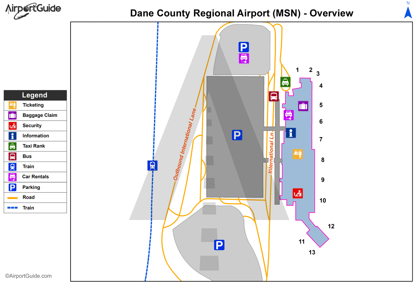
Services
Airframe Repair: |
None |
Powerplant Repair: |
None |
Bottled Oxygen: |
None |
Bulk Oxygen: |
None |
Fuel Available: |
100LL, Jet A |
Parking: |
Tiedowns available |
Maps & Diagrams
MSN Sectional
Flight Planning
at skyvector.com
at skyvector.com