
Location
Latitude: |
55-32-10.6993N (55.536305) |
Longitude: |
013-22-34.3121E (13.376198) |
Elevation: |
236 feet MSL (72 m MSL) |
Magnetic Variation: |
5.2 E (as of April 2024 from WMM2020 model) |
Time Zone: |
UTC +1.0 (Standard Time) UTC +2.0 (Daylight Savings Time) |
Contacts
Manager: |
: |
Operations
Airport Status: |
Operational |
Facility Use: |
Public |
Type: |
Airport |
Traffic Pattern Altitude (MSL): |
1236 feet (377 m) |
Based Aircraft
Annual Operations (as of )
Communications
| TWR: | 125 |
| TWR: | 118.8 |
| TWR: | 118.3 |
| TWR: | 118.25 |
| TWR: | 118.7 |
| GND: | 121.6 |
| APP: | 125.3 |
| ATIS: | 129.275 |
| Can Tho: | 118.8 |
| MALMO CON: | 135.9 |
Fixed Based Operators (FBOs) & Fuel
(Click on a business for detail)
Please help us keep this information up to date. This is a FREE SERVICE just like everything else on Airport Guide! If you see that a business needs to be added, modified, or deleted please fill out our Update Form.
To add, modify, or delete a business click here.
Please help us keep this information up to date. This is a FREE SERVICE just like everything else on Airport Guide! If you see that a business needs to be added, modified, or deleted please fill out our Update Form.
| Business Name | Frequency | Phone | Fuel Grade |
|---|
Flight Service Stations
| Primary | Alternate | |
| FSS on Field: | ||
| FSS Name (ID): | ||
| Frequency: | ||
| Toll Free Phone: |
Instrument Procedures / Charts
Terminal Procedures are only available for airports in several countries with more being added all the time. If you are looking for a specific country's charts, please send an email to support(at)airportguide.com stating the country name. This will be used to prioritize the implementation.
Navigation Aids (Navaids) near MMX
| Dist (NM) | ID | Morse Code | Name | Type | Freq | True Hdg | Mag Hdg |
|---|---|---|---|---|---|---|---|
| 0.2 | SUP | Sturup | VOR-DME | 113.00 | 134 | 129 | |
| 4.5 | NS | Sturup | NDB | 351 | 353 | 348 | |
| 4.6 | SS | Sturup | NDB | 420 | 173 | 168 | |
| 9.7 | ALM | Alma | VOR | 116.40 | 140 | 135 | |
| 26.1 | KAS | Kastrup | VOR-DME | 112.50 | 277 | 272 | |
| 33.3 | LJU | Ljungbyhed | VOR-DME | 113.40 | 349 | 344 | |
| 36.6 | OEM | Kristianstad | NDB | 363 | 41 | 36 | |
| 37.1 | VEY | Vedby | VOR | 116.90 | 351 | 346 | |
| 46.6 | SVD | Sveda | VOR-DME | 116.20 | 324 | 319 | |
| 46.8 | CDA | Codan | VOR-DME | 114.90 | 227 | 222 | |
| 47.1 | RK | Roskilde | NDB | 368 | 276 | 271 | |
| 55.0 | ROE | Ronne | VOR-DME | 112.00 | 120 | 115 | |
| 55.1 | ROE | Ronne | TACAN | 112.00 | 120 | 115 | |
| 59.6 | KOR | Korsa | VOR-DME | 112.80 | 265 | 260 | |
| 61.7 | TRT | Trent | VOR-DME | 108.45 | 184 | 179 | |
| 67.1 | TNO | Trano | VOR-DME | 117.40 | 283 | 278 | |
| 74.4 | LF | Ronneby | NDB | 380 | 57 | 51 | |
| 75.3 | BHD | Barth | DME | 115.40 | 198 | 193 | |
| 75.7 | BTH | Barth | NDB | 373 | 198 | 193 | |
| 80.3 | LP | Ronneby | NDB | 318 | 52 | 46 |
Nearby Airports with Fuel
| Dist (NM) | Name (Airport IDs) | True Hdg | Mag Hdg | Fuel Grade |
|---|
Notices to Airmen (NOTAMS)
Remarks
No remarks for this landing facility
Runways
Runway Summary
| Runways: | 11/29 17/35 |
| Longest Runway: | 17/35 is 9186 ft (2800 m) long |
| Runways with an Instrument Approach: |
MMX Airport Runway Details
| Runway 11/29 | 2615 ft x 59 ft (797 m x 18 m) | |
Runway 11 |
Runway 29 |
|
Elevation: |
232 | 228 |
Latitude: |
55.523102 | 55.521301 |
Longitude: |
13.3598 | 13.372 |
|
Runway True Alignment: |
105 | 285 |
Glide Path Angle: |
0.0 degrees | 0.0 degrees |
Threshold Elevation: |
232 | 228 |
| Runway 17/35 | 9186 ft x 148 ft (2800 m x 45 m) | |
| Runway Edge Lights: | Yes Intensity | |
Runway 17 |
Runway 35 |
|
Elevation: |
209 | 236 |
Latitude: |
55.54809951782 | 55.52310180664 |
Longitude: |
13.373800277709 | 13.378899574279 |
|
Runway True Alignment: |
173.4 | 353.4 |
Glide Path Angle: |
0.0 degrees | 0.0 degrees |
REIL: |
Yes | Yes |
Threshold Elevation: |
209 | 236 |
Services
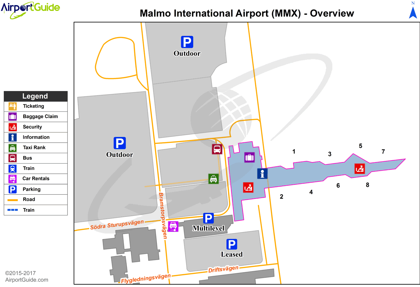
Maps & Diagrams
MMX Sectional
Flight Planning
at skyvector.com
at skyvector.com
