Location
Latitude: |
35-35-59.5700N (35.599881) |
Longitude: |
088-54-56.2030W (-88.915612) |
Elevation: |
433.3 feet MSL (132 m MSL) |
Magnetic Variation: |
2.6 W (as of April 2024 from WMM2020 model) |
Time Zone: |
UTC -6.0 (Standard Time) UTC -5.0 (Daylight Savings Time) |
From City: |
04 N.M. W of Jackson, Tennessee |
Found On: |
Memphis Chart |
FAA Region: |
ASO |
Contacts
Manager: |
Publicly owned: |
| STEVE SMITH 308 GRADY MONTGOMERY DR JACKSON, TN 38301 731-423-0995 |
JACKSON & MADISON CO ARPT AUTH 308 GRADY MONTGOMERY DR JACKSON, TN 38301 731-423-0995 |
Operations
Airport Status: |
Operational |
Facility Use: |
Public |
Type: |
Airport |
Activation Date: |
07/1942 |
Control tower: |
Yes |
Attendance (Months/Days/Hours): |
Months/Days/Hours ALL/MON-FRI/0600-2030 |
Boundary ARTCC: |
ZME (Memphis) |
Responsible ARTCC: |
ZME (Memphis) |
Lighting Schedule: |
SEE RMK |
Segmented Circle Indicator: |
Yes |
Traffic Pattern Altitude (MSL): |
1433 feet (437 m) |
NOTAMs Facility: |
MKL |
NOTAM-D Service: |
Yes |
International Airport of Entry: |
No |
Customs Landing Rights: |
No |
Military Landing Rights: |
Yes |
Civil/Military Joint Use: |
No |
Aircraft Rescue and Firefighting: |
Class IV ARFF Index: A Air Carrier Service: Scheduled Certification Date: 04/1989 |
Based Aircraft
| Single Engine: | 33 |
| Multi Engine: | 11 |
| Jet Engine: | 6 |
| GA Helicopters: | 3 |
| Military Aircraft: | 8 |
Annual Operations (as of 06/30/2023)
| Total Operations: | 31696 | |
| Air Taxi: | 1608 | 5.1% |
| GA Local: | 12278 | 38.7% |
| GA Itinerant: | 15548 | 49.1% |
| Military Aircraft: | 2262 | 7.1% |
Communications
| CTAF: | 127.150 |
| Unicom: | 122.950 |
| Tower: | JACKSON 127.15 249.95 Hrs: 0700-1900 |
| Ground: | 120.9 |
| Approach: | MEMPHIS ARTCC |
| Departure: | MEMPHIS ARTCC |
| ASOS: | 119.325 (731-424-0692) |
| NG OPS: | 138.75 |
| NG OPS: | 373.9 |
| NG OPS: | 41.5FM |
- APCH/DEP SVC PRVDD BY MEMPHIS ARTCC ON FREQS 134.65/316.15 (MCKELLAR RCAG).
Fixed Based Operators (FBOs) & Fuel
(Click on a business for detail)
Please help us keep this information up to date. This is a FREE SERVICE just like everything else on Airport Guide! If you see that a business needs to be added, modified, or deleted please fill out our Update Form.
To add, modify, or delete a business click here.
Please help us keep this information up to date. This is a FREE SERVICE just like everything else on Airport Guide! If you see that a business needs to be added, modified, or deleted please fill out our Update Form.
Area Code: 731 |
| Business Name | Frequency | Phone | Fuel Grade |
|---|---|---|---|
| American Aviation Services, Inc.
Update FBO info |
427-6020 | ||
| BG Pilot Service
Update FBO info |
664-7492 | ||
| Fair Planes, Inc.
Update FBO info |
668-9510 | ||
| U.S. Aviation Services, Inc.
Update FBO info |
Unicom 122.95 | 427-0191, 800-453-6904 | 100LL, Jet A |
Flight Service Stations
| Primary | Alternate | |
| FSS on Field: | N | |
| FSS Name (ID): | Jackson(MKL) | |
| Frequency: | ||
| Toll Free Phone: | 1-800-WX-BRIEF |
Instrument Procedures / Charts
FAA Terminal Procedures valid from 0901Z 03/21/24 to 0901Z 04/18/24.
There are various types of charts available for an airport. They are listed in the Page Type column. Here is a legend for those types:
APD - Airport Diagram
DP - Departure Procedure Charts
HOT - Hot Spots
IAP - Instrument Approach Procedure Charts
MIN - Minimums
STAR - Standard Terminal Arrival Charts
| Page Type | Page Name | Volume | Action Since Last Cycle |
|---|---|---|---|
| APD | AIRPORT DIAGRAM | SE-1 | Changed |
| IAP | ILS OR LOC RWY 02 | SE-1 | |
| IAP | RNAV (GPS) RWY 02 | SE-1 | |
| IAP | RNAV (GPS) RWY 20 | SE-1 | |
| IAP | VOR RWY 02 | SE-1 | |
| MIN | ALTERNATE MINIMUMS | SE-1 | |
| MIN | TAKEOFF MINIMUMS | SE-1 |
Terminal Procedures are only available for airports in several countries with more being added all the time. If you are looking for a specific country's charts, please send an email to support(at)airportguide.com stating the country name. This will be used to prioritize the implementation.
Navigation Aids (Navaids) near MKL
| Dist (NM) | ID | Morse Code | Name | Type | Freq | True Hdg | Mag Hdg |
|---|---|---|---|---|---|---|---|
| 0.3 | MKL | _ _ _ . _ . _ . . | Mc Kellar | VOR-DME | 112.00 | 48 | 51 |
| 5.4 | MKL | _ _ _ . _ . _ . . | Mersy | NDB | 394 | 201 | 204 |
| 27.2 | JKS | . _ _ _ _ . _ . . . | Jacks Creek | VOR-DME | 109.40 | 89 | 92 |
| 29.3 | SZY | . . . _ _ . . _ . _ _ | Sibley | NDB | 386 | 137 | 140 |
| 31.8 | DYR | _ . . _ . _ _ . _ . | Dyersburg | TACAN | 116.80 | 322 | 325 |
| 32.8 | COO | _ . _ . _ _ _ _ _ _ | Covington | NDB | 326 | 269 | 271 |
| 33.2 | FYE | . . _ . _ . _ _ . | Somerville | NDB | 255 | 224 | 226 |
| 36.5 | HZD | . . . . _ _ . . _ . . | Huntingdon | NDB | 217 | 36 | 39 |
| 38.0 | UU | . . _ . . _ | Seyer | NDB | 334 | 157 | 160 |
| 42.0 | UC | . . _ _ . _ . | Obion | NDB | 212 | 354 | 357 |
| 45.9 | TIQ | _ . . _ _ . _ | Trainer | NDB | 410 | 31 | 34 |
| 53.3 | MIG | _ _ . . _ _ . | Millington | NDB | 232 | 249 | 251 |
| 54.2 | GOJ | _ _ . _ _ _ . _ _ _ | Gosnell | VOR | 111.80 | 293 | 295 |
| 57.4 | HLI | . . . . . _ . . . . | Holly Springs | VORTAC | 112.40 | 209 | 211 |
| 60.5 | SPQ | . . . . _ _ . _ _ . _ | Spain | NDB | 414 | 247 | 249 |
| 61.7 | MEM | _ _ . _ _ | Memphis Metropolitn | VOT | 111.00 | 237 | 239 |
| 63.0 | MEM | _ _ . _ _ | Memphis | VORTAC | 117.50 | 236 | 238 |
| 63.3 | JHG | . _ _ _ . . . . _ _ . | Hohenwald | NDB | 257 | 97 | 100 |
| 65.0 | AEY | . _ . _ . _ _ | Waverly | NDB | 329 | 61 | 64 |
| 65.2 | ME | _ _ . | Elvis | NDB | 287 | 240 | 242 |
Nearby Airports with Fuel
Notices to Airmen (NOTAMS)
Remarks
| A110-2 | BASE OPS 0630-1600 MON-FRI; PPR C731-425-5600. |
| A110-3 | PPR FOR GND ACCESS TO FLD 2130-0600 - 731-394-1755. |
| A110-4 | ACR OPS MORE THAN 9 PAX SEATS NA IN EXCESS OF 15 MIN BFR OR AFT SKED ARR OR DEP TIMES WO PRIOR AVBLTY COORD WITH AMGR & CFM. |
| A110-5 | FOR CD CTC MEMPHIS ARTCC AT 901-368-8453/8449. |
| A17 | AFT HR - 731-394-1755. |
| A26 | CLSD TO UNSKED ACR OPS MORE THAN 30 PAX SEATS EXC 24 HR PPR - AMGR. |
| A33-02/20 | FADED. |
| A33-11/29 | FADED. |
| A34-02/20 | GROOVED 55 FT EACH SIDE OF CNTRLN. |
| A43-02 | PAPI UNUSBL BYD 8 DEG LEFT AND RIGHT OF CNTRLN. |
| A81-APT | WHEN ATCT CLSD ACTVT MALSR RWY 02; HIRL RWY 02/20, MIRL RWY 11/29 - CTAF. |
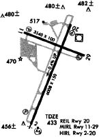
Runways
Runway Summary
| Runways: | 02/20 11/29 |
| Longest Runway: | 02/20 is 6005 ft (1830 m) long |
| Runways with an Instrument Approach: | 02 |
MKL Airport Runway Details
| Runway 02/20 | 6005 ft x 150 ft (1830 m x 46 m) | |
| Runway Length Source: | 3RD PARTY SURVEY as of 08/01/2020 | |
| Surface: | Asphalt - Fair condition - Saw-cut or plastic grooved | |
| Runway Pavement Class: | 34 /F/C/X/T | |
| Runway Edge Lights: | High Intensity | |
Runway Weight Bearing Capacity (in thousands of pounds) |
||
| Single Wheel Landing Gear: | 55.0 | |
| Dual Wheel Landing Gear: | 80.0 | |
| Dual Tandem Wheel Landing Gear: | 125.0 | |
Runway 02 |
Runway 20 |
|
Elevation: |
433.3 | 411.2 |
Latitude: |
35-35-25.6475N | 35-36-20.6212N |
Longitude: |
088-55-10.9704W | 088-54-43.4556W |
|
Runway True Alignment: |
022 | 202 |
ILS Type: |
ILS/DME | |
Glide Path Angle: |
3.0 degrees | 3.0 degrees |
Traffic Pattern: |
Left | Left |
Runway Markings Type: |
Precision Instrument | Nonprecision Instrument |
Runway Markings Condition: |
Fair | Fair |
Object at End: |
TREE | |
Object Height: |
40 | |
Distance from End: |
1400 | |
Object Centerline Offset: |
600 ft. right of centerline | |
Visual Glide Slope Indicators: |
4-Light PAPI On Left Side Of Runway | 4-Light PAPI On Left Side Of Runway |
Approach Light System: |
1,400 Foot Medium Intensity Approach Lighting System With Runway Alignment Indicator Lights | |
REIL: |
No | |
Threshold Crossing Height: |
29 | 47 |
| Runway 11/29 | 3539 ft x 100 ft (1079 m x 30 m) | |
| Runway Length Source: | 3RD PARTY SURVEY as of 08/01/2020 | |
| Surface: | Asphalt - Fair condition - No special surface treatment | |
| Runway Pavement Class: | 13 /F/D/X/T | |
| Runway Edge Lights: | Medium Intensity | |
Runway Weight Bearing Capacity (in thousands of pounds) |
||
| Single Wheel Landing Gear: | 27.0 | |
Runway 11 |
Runway 29 |
|
Elevation: |
407.6 | 415.7 |
Latitude: |
35-36-17.1194N | 35-36-03.8589N |
Longitude: |
088-55-14.3184W | 088-54-34.6560W |
|
Runway True Alignment: |
112 | 292 |
Glide Path Angle: |
3.0 degrees | 3.0 degrees |
Traffic Pattern: |
Left | Left |
Runway Markings Type: |
Basic | Basic |
Runway Markings Condition: |
Fair | Fair |
Object at End: |
TREE | TREE |
Object Height: |
66 | 45 |
Distance from End: |
1650 | 1100 |
Object Centerline Offset: |
600 ft. right of centerline | |
Visual Glide Slope Indicators: |
4-Light PAPI On Left Side Of Runway | 4-Light PAPI On Left Side Of Runway |
Threshold Crossing Height: |
34 | 23 |
Services
Bottled Oxygen: |
None |
Bulk Oxygen: |
None |
Fuel Available: |
100LL |
Landing Fees: |
No |
Parking: |
Tiedowns available |
Maps & Diagrams
MKL Sectional
Flight Planning
at skyvector.com
at skyvector.com