Location
Latitude: |
44-38-12.7670N (44.63688) |
Longitude: |
090-11-21.5760W (-90.189327) |
Elevation: |
1277.8 feet MSL (389 m MSL) |
Magnetic Variation: |
2.5 W (as of April 2024 from WMM2020 model) |
Time Zone: |
UTC -6.0 (Standard Time) UTC -5.0 (Daylight Savings Time) |
From City: |
01 N.M. S of Marshfield, Wisconsin |
Found On: |
Green Bay Chart |
FAA Region: |
AGL |
Contacts
Manager: |
Publicly owned: |
| JEFF GAIER 400 W 29TH ST MARSHFIELD, WI 54449 715-387-2211 |
CITY OF MARSHFIELD P.O. BOX 727 MARSHFIELD, WI 54449-0727 715-384-2919 |
Operations
Airport Status: |
Operational |
Facility Use: |
Public |
Type: |
Airport |
Activation Date: |
09/1945 |
Control tower: |
No |
Attendance (Months/Days/Hours): |
Months/Days/Hours ALL/MON-SAT/0800-1700 |
Boundary ARTCC: |
ZMP (Minneapolis) |
Responsible ARTCC: |
ZMP (Minneapolis) |
Lighting Schedule: |
SEE RMK |
Segmented Circle Indicator: |
No |
Traffic Pattern Altitude (MSL): |
2278 feet (694 m) |
NOTAMs Facility: |
MFI |
NOTAM-D Service: |
Yes |
International Airport of Entry: |
No |
Customs Landing Rights: |
No |
Military Landing Rights: |
Yes |
Civil/Military Joint Use: |
No |
Based Aircraft
| Single Engine: | 11 |
| Multi Engine: | 3 |
| Jet Engine: | 1 |
| GA Helicopters: | 1 |
Annual Operations (as of 08/02/2023)
| Total Operations: | 23050 | |
| Air Taxi: | 2500 | 10.8% |
| GA Local: | 10000 | 43.4% |
| GA Itinerant: | 10400 | 45.1% |
| Military Aircraft: | 150 | 0.7% |
Communications
| CTAF: | 123.000 |
| Unicom: | 123.000 |
| ASOS: | 121.575 (715-384-3046) |
- APCH/DEP SVC PRVDD BY MINNEAPOLIS ARTCC ON FREQS 124.4/317.7 (MOSINEE RCAG).
Fixed Based Operators (FBOs) & Fuel
(Click on a business for detail)
Please help us keep this information up to date. This is a FREE SERVICE just like everything else on Airport Guide! If you see that a business needs to be added, modified, or deleted please fill out our Update Form.
To add, modify, or delete a business click here.
Please help us keep this information up to date. This is a FREE SERVICE just like everything else on Airport Guide! If you see that a business needs to be added, modified, or deleted please fill out our Update Form.
Area Code: 715 |
| Business Name | Frequency | Phone | Fuel Grade |
|---|---|---|---|
| Aviation Services, Inc.
Update FBO info |
Unicom 123.0 | 384-3149 | 100LL, Jet A |
| Duffys Aircraft Sales & Leasing
Update FBO info |
123.0 | 387-2211 |
Flight Service Stations
| Primary | Alternate | |
| FSS on Field: | N | |
| FSS Name (ID): | Green Bay(GRB) | |
| Frequency: | ||
| Toll Free Phone: | 1-800-WX-BRIEF |
Instrument Procedures / Charts
FAA Terminal Procedures valid from 0901Z 03/21/24 to 0901Z 04/18/24.
There are various types of charts available for an airport. They are listed in the Page Type column. Here is a legend for those types:
APD - Airport Diagram
DP - Departure Procedure Charts
HOT - Hot Spots
IAP - Instrument Approach Procedure Charts
MIN - Minimums
STAR - Standard Terminal Arrival Charts
| Page Type | Page Name | Volume | Action Since Last Cycle |
|---|---|---|---|
| IAP | RNAV (GPS) RWY 05 | EC-3 | |
| IAP | RNAV (GPS) RWY 16 | EC-3 | |
| IAP | RNAV (GPS) RWY 23 | EC-3 | |
| IAP | RNAV (GPS) RWY 34 | EC-3 | |
| MIN | ALTERNATE MINIMUMS | EC-3 | |
| MIN | TAKEOFF MINIMUMS | EC-3 |
Terminal Procedures are only available for airports in several countries with more being added all the time. If you are looking for a specific country's charts, please send an email to support(at)airportguide.com stating the country name. This will be used to prioritize the implementation.
Navigation Aids (Navaids) near MFI
| Dist (NM) | ID | Morse Code | Name | Type | Freq | True Hdg | Mag Hdg |
|---|---|---|---|---|---|---|---|
| 0.3 | MFI | _ _ . . _ . . . | Marshfield | NDB | 391 | 1 | 4 |
| 4.4 | DU | _ . . . . _ | Calin | NDB | 266 | 158 | 161 |
| 14.7 | VIQ | . . . _ . . _ _ . _ | Neillsville | NDB | 368 | 251 | 253 |
| 22.2 | ISW | . . . . . . _ _ | Wisconsin Rapids | NDB | 215 | 137 | 140 |
| 23.2 | PH | . _ _ . . . . . | Bayye | NDB | 351 | 83 | 86 |
| 26.0 | EK | . _ . _ | Nepco | NDB | 326 | 150 | 153 |
| 28.6 | MDZ | _ _ _ . . _ _ . . | Medford | NDB | 335 | 349 | 351 |
| 28.6 | AUW | . _ . . _ . _ _ | Wausau | VOR-DME | 111.60 | 63 | 66 |
| 28.7 | STE | . . . _ . | Stevens Point | VORTAC | 110.60 | 101 | 104 |
| 29.7 | FZK | . . _ . _ _ . . _ . _ | Wausau | NDB | 243 | 53 | 56 |
| 36.4 | BCK | _ . . . _ . _ . _ . _ | Black River Falls | NDB | 362 | 231 | 233 |
| 39.5 | RRL | . _ . . _ . . _ . . | Merrill | NDB | 257 | 31 | 34 |
| 41.8 | VOK | . . . _ _ _ _ _ . _ | Volk | TACAN | 110.40 | 184 | 186 |
| 46.2 | CMY | _ . _ . _ _ _ . _ _ | Mccoy | NDB | 412 | 205 | 207 |
| 53.3 | PCZ | . _ _ . _ . _ . _ _ . . | Waupaca | NDB | 382 | 109 | 112 |
| 53.7 | EA | . . _ | Maggs | NDB | 239 | 290 | 292 |
| 55.4 | AIG | . _ . . _ _ . | Antigo | NDB | 347 | 55 | 58 |
| 57.1 | EAU | . . _ . . _ | Eau Claire | VORTAC | 113.65 | 286 | 288 |
| 59.2 | HBW | . . . . _ . . . . _ _ | Kickapoo | NDB | 251 | 186 | 188 |
| 59.6 | LS | . _ . . . . . | Mindi | NDB | 272 | 230 | 232 |
Nearby Airports with Fuel
Notices to Airmen (NOTAMS)
Remarks
| A110-1 | BIRDS, WATERFOWL & DEER ON & INVOF ARPT. |
| A110-2 | RY 34 DEPARTING ACFT CLIMB TO 2000 FT MSL PRIOR TO INITIATING RIGHT TURN. |
| A110-3 | FOR CD IF UNA TO CTC ON FSS FREQ, CTC MINNEAPOLIS ARTCC AT 651-463-5588. |
| A17 | FOR AFT HRS SVC CALL 715-743-6634. |
| A70-FUEL-10 | 0LL 24 HR FUEL AVBL WITH CREDIT CARD. |
| A81-APT | MIRL RWY 16/34 & RWY 05/23 PRESET TO LOW SS-SR; TO INCR INTST AND ACTVT MALSR RWY 34; REIL RWY 16; VASI RWY 16 & 34; PAPI RWY 05 - CTAF. |
Runways
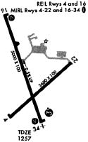
Runway Summary
| Runways: | 05/23 16/34 |
| Longest Runway: | 16/34 is 5002 ft (1525 m) long |
| Runways with an Instrument Approach: | 34 |
MFI Airport Runway Details
| Runway 05/23 | 3597 ft x 100 ft (1096 m x 30 m) | |
| Runway Length Source: | 3RD PARTY SURVEY as of 11/04/2009 | |
| Surface: | Asphalt - Fair condition - No special surface treatment | |
| Runway Edge Lights: | Medium Intensity | |
Runway Weight Bearing Capacity (in thousands of pounds) |
||
| Single Wheel Landing Gear: | 35.0 | |
| Dual Wheel Landing Gear: | 45.0 | |
Runway 05 |
Runway 23 |
|
Elevation: |
1252.6 | 1249.2 |
Latitude: |
44-37-55.3012N | 44-38-19.7494N |
Longitude: |
090-11-33.0454W | 090-10-56.9660W |
|
Runway True Alignment: |
046 | 227 |
Glide Path Angle: |
3.0 degrees | 0.0 degrees |
Traffic Pattern: |
Right | Left |
Runway Markings Type: |
Nonprecision Instrument | Nonprecision Instrument |
Runway Markings Condition: |
Good | Good |
Object at End: |
TREES | |
Object Height: |
35 | |
Distance from End: |
500 | |
Object Centerline Offset: |
200 ft. left of centerline | |
Visual Glide Slope Indicators: |
2-Light PAPI On Left Side Of Runway | |
REIL: |
No | |
Touchdown Lights: |
No | No |
Centerline Lights: |
No | No |
Threshold Crossing Height: |
29 |
| Runway 16/34 | 5002 ft x 100 ft (1525 m x 30 m) | |
| Runway Length Source: | 3RD PARTY SURVEY as of 11/04/2009 | |
| Surface: | Asphalt - Fair condition - No special surface treatment | |
| Runway Edge Lights: | Medium Intensity | |
Runway Weight Bearing Capacity (in thousands of pounds) |
||
| Single Wheel Landing Gear: | 35.0 | |
| Dual Wheel Landing Gear: | 50.0 | |
Runway 16 |
Runway 34 |
|
Elevation: |
1277.8 | 1255.4 |
Latitude: |
44-38-39.5976N | 44-37-53.6347N |
Longitude: |
090-11-38.8965W | 090-11-13.6009W |
|
Runway True Alignment: |
159 | 339 |
ILS Type: |
SDF | |
Glide Path Angle: |
3.0 degrees | 3.0 degrees |
Traffic Pattern: |
Right | Left |
Runway Markings Type: |
Nonprecision Instrument | Nonprecision Instrument |
Runway Markings Condition: |
Good | Good |
Object at End: |
TREES | TREES |
Object Height: |
120 | 15 |
Distance from End: |
2280 | 230 |
Object Centerline Offset: |
200 ft. left of centerline | |
Visual Glide Slope Indicators: |
2-Box VASI On Left Side Of Runway | 2-Box VASI On Left Side Of Runway |
Approach Light System: |
1,400 Foot Medium Intensity Approach Lighting System With Runway Alignment Indicator Lights | |
REIL: |
Yes | No |
Touchdown Lights: |
No | No |
Centerline Lights: |
No | No |
Threshold Crossing Height: |
35 | 42 |
Services
Airframe Repair: |
None |
Powerplant Repair: |
None |
Bottled Oxygen: |
None |
Bulk Oxygen: |
None |
Fuel Available: |
100LL, UL91 |
Landing Fees: |
No |
Parking: |
Hangars and tiedowns available |
Maps & Diagrams
MFI Sectional
Flight Planning
at skyvector.com
at skyvector.com