
Location
Latitude: |
19-26-10.68N (19.4363) |
Longitude: |
099-04-19.5528W (-99.072098) |
Elevation: |
7316 feet MSL (2230 m MSL) |
Magnetic Variation: |
3.9 E (as of April 2024 from WMM2020 model) |
Time Zone: |
UTC -6.0 (Standard Time) UTC -5.0 (Daylight Savings Time) |
Contacts
Manager: |
: |
Operations
Airport Status: |
Operational |
Facility Use: |
Public |
Type: |
Airport |
Traffic Pattern Altitude (MSL): |
8316 feet (2535 m) |
Based Aircraft
Annual Operations (as of )
Communications
| MEXICO INFO: | 126.9 |
| MEXICO TWR: | 118.55 |
| MEXICO CLNC DEL: | 122.1 |
| GND: | 121 |
| MEXICO APP: | 121.2 |
| MEXICO DEP: | 120.5 |
| ATIS: | 127.65 |
| MEXICO ARR: | 129.6 |
Fixed Based Operators (FBOs) & Fuel
(Click on a business for detail)
Please help us keep this information up to date. This is a FREE SERVICE just like everything else on Airport Guide! If you see that a business needs to be added, modified, or deleted please fill out our Update Form.
To add, modify, or delete a business click here.
Please help us keep this information up to date. This is a FREE SERVICE just like everything else on Airport Guide! If you see that a business needs to be added, modified, or deleted please fill out our Update Form.
| Business Name | Frequency | Phone | Fuel Grade |
|---|
Flight Service Stations
| Primary | Alternate | |
| FSS on Field: | ||
| FSS Name (ID): | ||
| Frequency: | ||
| Toll Free Phone: |
Instrument Procedures / Charts
Terminal Procedures are only available for airports in several countries with more being added all the time. If you are looking for a specific country's charts, please send an email to support(at)airportguide.com stating the country name. This will be used to prioritize the implementation.
Navigation Aids (Navaids) near MEX
| Dist (NM) | ID | Morse Code | Name | Type | Freq | True Hdg | Mag Hdg |
|---|---|---|---|---|---|---|---|
| 0.3 | MEX | Mexico | VOR-DME | 115.60 | 59 | 55 | |
| 5.1 | MW | Plaza | NDB | 370 | 239 | 235 | |
| 11.4 | SMO | Mateo | VOR-DME | 112.10 | 309 | 305 | |
| 12.3 | TPX | Tepexpan | NDB | 359 | 30 | 26 | |
| 18.5 | SLM | Lucia | VOR-DME | 116.60 | 7 | 3 | |
| 22.3 | OTU | Otumba | VOR-DME | 115.00 | 48 | 44 | |
| 28.7 | TLC | Toluca | VOR-DME | 114.30 | 259 | 255 | |
| 38.4 | CVJ | Cuernavaca | VOR-DME | 113.90 | 197 | 193 | |
| 39.9 | APN | Apan | VOR-DME | 114.80 | 72 | 68 | |
| 40.2 | CUA | Cuautla | VOR-DME | 116.30 | 166 | 162 | |
| 42.9 | PTJ | Pasteje | VOR-DME | 114.50 | 287 | 283 | |
| 43.0 | PBC | Puebla | VOR-DME | 115.20 | 112 | 108 | |
| 46.8 | TEQ | Tequesquitengo | VOR-DME | 113.10 | 192 | 188 | |
| 47.1 | PCA | Pachuca | VOR-DME | 112.70 | 27 | 23 | |
| 95.0 | QET | Queretaro | VOR-DME | 113.00 | 318 | 314 |
Nearby Airports with Fuel
| Dist (NM) | Name (Airport IDs) | True Hdg | Mag Hdg | Fuel Grade |
|---|
Notices to Airmen (NOTAMS)
Remarks
No remarks for this landing facility
Runways
Runway Summary
| Runways: | 05L/23R 05R/23L |
| Longest Runway: | 05L/23R is 12966 ft (3952 m) long |
| Runways with an Instrument Approach: |
MEX Airport Runway Details
| Runway 05L/23R | 12966 ft x 148 ft (3952 m x 45 m) | |
| Runway Edge Lights: | Yes Intensity | |
Runway 05L |
Runway 23R |
|
Elevation: |
7309 | 7311 |
Latitude: |
19.42760086059 | 19.44569969177 |
Longitude: |
-99.09049987792 | -99.05819702148 |
|
Runway True Alignment: |
59.4 | 239.4 |
Glide Path Angle: |
0.0 degrees | 0.0 degrees |
REIL: |
Yes | Yes |
Threshold Elevation: |
7309 | 7311 |
Displaced Threshold: |
1034 | 1641 |
| Runway 05R/23L | 12795 ft x 148 ft (3900 m x 45 m) | |
| Runway Edge Lights: | Yes Intensity | |
Runway 05R |
Runway 23L |
|
Elevation: |
7316 | 7295 |
Latitude: |
19.42700004577 | 19.44490051269 |
Longitude: |
-99.08580017089 | -99.05390167236 |
|
Runway True Alignment: |
59.4 | 239.4 |
Glide Path Angle: |
0.0 degrees | 0.0 degrees |
REIL: |
Yes | Yes |
Threshold Elevation: |
7316 | 7295 |
Displaced Threshold: |
1493 |
Services
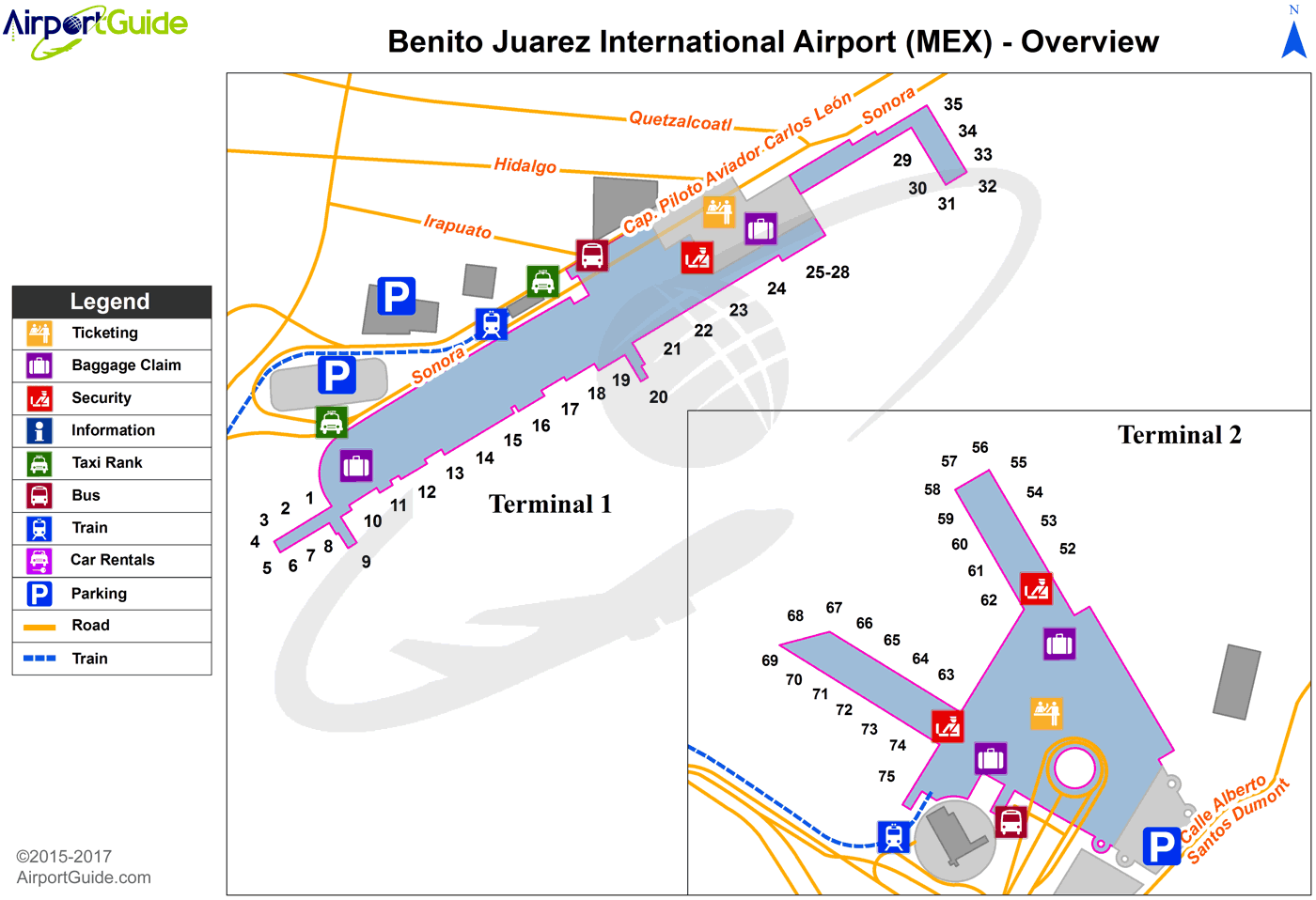
Maps & Diagrams
MEX Sectional
Flight Planning
at skyvector.com
at skyvector.com
