Location
Latitude: |
39-13-10.1000N (39.219472) |
Longitude: |
106-18-59.1000W (-106.316417) |
Elevation: |
9933.5 feet MSL (3028 m MSL) |
Magnetic Variation: |
8.3 E (as of April 2024 from WMM2020 model) |
Time Zone: |
UTC -7.0 (Standard Time) UTC -6.0 (Daylight Savings Time) |
From City: |
02 N.M. SW of Leadville, Colorado |
Found On: |
Denver Chart |
FAA Region: |
ANM |
Contacts
Manager: |
Publicly owned: |
| BRETT COTTRELL 915 CR 23, BOX 952 LEADVILLE, CO 80461 719-486-0307 |
COUNTY COMMISSIONER LAKE COUNTY COURTHOUSE LEADVILLE, CO 80461 719-486-4181 |
Operations
Airport Status: |
Operational |
Facility Use: |
Public |
Type: |
Airport |
Activation Date: |
01/1962 |
Control tower: |
No |
Attendance (Months/Days/Hours): |
Months/Days/Hours MAY-SEP/ALL/0730-1630 |
Boundary ARTCC: |
ZDV (Denver) |
Responsible ARTCC: |
ZDV (Denver) |
Lighting Schedule: |
SEE RMK |
Segmented Circle Indicator: |
Yes |
Traffic Pattern Altitude (MSL): |
10934 feet (3333 m) |
NOTAMs Facility: |
LXV |
NOTAM-D Service: |
Yes |
International Airport of Entry: |
No |
Customs Landing Rights: |
No |
Military Landing Rights: |
Yes |
Civil/Military Joint Use: |
No |
Based Aircraft
| Single Engine: | 5 |
Annual Operations (as of 05/18/2018)
| Total Operations: | 5000 | |
| Air Taxi: | 200 | 4.0% |
| GA Local: | 1800 | 36.0% |
| GA Itinerant: | 1000 | 20.0% |
| Military Aircraft: | 2000 | 40.0% |
Communications
| CTAF: | 122.800 |
| Unicom: | 122.800 |
| ASOS: | 118.375 (719-486-8441) |
- APCH/DEP CTL SVC PRVDD BY DENVER ARTCC (ZDV) ON FREQS 119.85/363.15 (ASPEN RCAG).
Fixed Based Operators (FBOs) & Fuel
(Click on a business for detail)
Please help us keep this information up to date. This is a FREE SERVICE just like everything else on Airport Guide! If you see that a business needs to be added, modified, or deleted please fill out our Update Form.
To add, modify, or delete a business click here.
Please help us keep this information up to date. This is a FREE SERVICE just like everything else on Airport Guide! If you see that a business needs to be added, modified, or deleted please fill out our Update Form.
Area Code: 719 |
| Business Name | Frequency | Phone | Fuel Grade |
|---|---|---|---|
| Leadville Airport, Inc.
Update FBO info |
Unicom 122.8 | 486-2627 | 100LL, Jet A (truck) |
Flight Service Stations
| Primary | Alternate | |
| FSS on Field: | N | |
| FSS Name (ID): | Denver(DEN) | |
| Frequency: | ||
| Toll Free Phone: | 1-800-WX-BRIEF |
Instrument Procedures / Charts
FAA Terminal Procedures valid from 0901Z 03/21/24 to 0901Z 04/18/24.
There are various types of charts available for an airport. They are listed in the Page Type column. Here is a legend for those types:
APD - Airport Diagram
DP - Departure Procedure Charts
HOT - Hot Spots
IAP - Instrument Approach Procedure Charts
MIN - Minimums
STAR - Standard Terminal Arrival Charts
| Page Type | Page Name | Volume | Action Since Last Cycle |
|---|---|---|---|
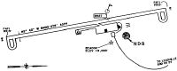
| IAP | RNAV (GPS) RWY 16 | SW-1 | |
| MIN | ALTERNATE MINIMUMS | SW-1 | |
| MIN | TAKEOFF MINIMUMS | SW-1 | |
| ODP | DAVVY TWO (OBSTACLE) (RNAV) | SW-1 | |
| ODP | LOZUL FOUR (OBSTACLE) (RNAV) | SW-1 |
Terminal Procedures are only available for airports in several countries with more being added all the time. If you are looking for a specific country's charts, please send an email to support(at)airportguide.com stating the country name. This will be used to prioritize the implementation.
Navigation Aids (Navaids) near LXV
| Dist (NM) | ID | Morse Code | Name | Type | Freq | True Hdg | Mag Hdg |
|---|---|---|---|---|---|---|---|
| 25.2 | RDY | . _ . _ . . _ . _ _ | Sardy | TACAN | 114.30 | 269 | 261 |
| 29.9 | DBL | _ . . _ . . . . _ . . | Red Table | VOR-DME | 113.00 | 296 | 288 |
| 39.8 | SXW | . . . _ . . _ . _ _ | Snow | VOR-DME | 109.20 | 308 | 300 |
| 47.3 | RLG | . _ . . _ . . _ _ . | Kremmling | VOR-DME | 113.80 | 352 | 344 |
| 57.1 | HBU | . . . . _ . . . . . _ | Blue Mesa | VOR-DME | 114.90 | 216 | 208 |
| 67.7 | RIL | . _ . . . . _ . . | Rifle | VOR-DME | 113.35 | 286 | 277 |
| 68.5 | BJC | _ . . . . _ _ _ _ . _ . | Jeffco | VOR-DME | 115.40 | 52 | 44 |
| 69.7 | AP | . _ . _ _ . | Casse | NDB | 260 | 77 | 69 |
| 71.5 | APA | . _ . _ _ . . _ | Centennial | VOT | 108.20 | 72 | 64 |
| 78.1 | BKF | _ . . . _ . _ . . _ . | Buckley | TACAN | 109.60 | 67 | 59 |
| 78.9 | BQZ | _ . . . _ _ . _ _ _ . . | Robert | VOR-DME | 112.20 | 341 | 333 |
| 79.2 | COS | _ . _ . _ _ _ . . . | Colorado Springs | VOT | 110.40 | 107 | 99 |
| 79.6 | FCS | . . _ . _ . _ . . . . | Butts | VOR-DME | 108.80 | 113 | 105 |
| 79.8 | IHS | . . . . . . . . . | Ironhorse | NDB | 335 | 113 | 105 |
| 80.1 | BRK | _ . . . . _ . _ . _ | Black Forest | VOR-DME | 112.50 | 101 | 93 |
| 81.0 | CO | _ . _ . _ _ _ | Petey | NDB | 407 | 112 | 104 |
| 83.5 | FQF | . . _ . _ _ . _ . . _ . | Falcon | VORTAC | 116.30 | 69 | 61 |
| 84.5 | DEN | _ . . . _ . | Denver | VOR-DME | 117.90 | 64 | 56 |
| 85.4 | MTJ | _ _ _ . _ _ _ | Montrose | VOR-DME | 117.10 | 240 | 231 |
| 86.2 | DEN | _ . . . _ . | Denver | VOT | 110.00 | 62 | 54 |
Nearby Airports with Fuel
Notices to Airmen (NOTAMS)
Remarks
| A110-1 | OBSTRN LGTS ON BCN TWR. |
| A110-10 | FOR CD CTC DENVER ARTCC AT 303-651-4257. |
| A110-2 | ALL TWYS & NEW RAMP AREA MKD WITH BLUE & WHITE REFLECTORS. |
| A110-3 | TWY C AND OLD RAMP HAVE POTHOLES & LOOSE AGGREGATE. |
| A110-5 | RY H1 HAS 20-30 FT TREES 130 FT EAST OF PAD. |
| A110-6 | ALL PAVEMENT EDGES HAVE SOFT SHOULDERS. |
| A110-8 | RY 34 HA +50 FT POWER LINES 750 FT RIGHT OF THRESHOLD. |
| A17 | PPR FOR SVC AFT HRS CALL 719-427-0026. |
| A33-H1 | RY H1 HAS 6-8 INCH LIP ALL AROUND EDGES; CONCRETE HAS LONGITUDINAL & CORNER CRACKING. |
| A81-APT | ACTVT PAPI RWY 16 & 34; MIRL RWY 16/34 - CTAF. |
Runways
Runway Summary
| Runways: | 16/34 H1 |
| Longest Runway: | 16/34 is 6400 ft (1951 m) long |
| Runways with an Instrument Approach: |
LXV Airport Runway Details
| Runway 16/34 | 6400 ft x 75 ft (1951 m x 23 m) | |
| Runway Length Source: | 3RD PARTY SURVEY as of 10/27/2009 | |
| Surface: | Asphalt - Good condition - No special surface treatment | |
| Runway Edge Lights: | Medium Intensity | |
Runway Weight Bearing Capacity (in thousands of pounds) |
||
| Single Wheel Landing Gear: | 20.0 | |
| Dual Wheel Landing Gear: | 20.0 | |
Runway 16 |
Runway 34 |
|
Elevation: |
9930.7 | 9924.6 |
Latitude: |
39-13-41.2404N | 39-12-38.9079N |
Longitude: |
106-19-05.9328W | 106-18-52.3221W |
|
Runway True Alignment: |
170 | 350 |
Glide Path Angle: |
3.0 degrees | 3.0 degrees |
Traffic Pattern: |
Right | Left |
Runway Markings Type: |
Nonprecision Instrument | Nonprecision Instrument |
Runway Markings Condition: |
Good | Good |
Visual Glide Slope Indicators: |
2-Light PAPI On Left Side Of Runway | 2-Light PAPI On Left Side Of Runway |
Threshold Crossing Height: |
45 | 45 |
| Helipad H1 | 150 ft x 100 ft (46 m x 30 m) | |
| Surface: | Asphalt - Good condition - No special surface treatment | |
Helipad H1 |
||
Elevation: |
9958.0 | |
Latitude: |
39-13-12.4900N | |
Longitude: |
106-18-54.9600W | |
Glide Path Angle: |
0.0 degrees | 0.0 degrees |
Runway Markings Type: |
Nonstandard (other than numbers only) | |
Runway Markings Condition: |
Good |
Services
Airframe Repair: |
Major |
Powerplant Repair: |
Major |
Bottled Oxygen: |
None |
Bulk Oxygen: |
Low Pressure |
Fuel Available: |
100LL |
Landing Fees: |
No |
Parking: |
Hangars and tiedowns available |
Other Services: |
FAA Repair Station. Cessna Pilot Center. |
Maps & Diagrams
LXV Sectional
Flight Planning
at skyvector.com
at skyvector.com