Location
Latitude: |
37-51-29.9040N (37.858307) |
Longitude: |
080-23-58.1370W (-80.399483) |
Elevation: |
2301.6 feet MSL (702 m MSL) |
Magnetic Variation: |
8.6 W (as of April 2024 from WMM2020 model) |
Time Zone: |
UTC -5.0 (Standard Time) UTC -4.0 (Daylight Savings Time) |
From City: |
03 N.M. N of Lewisburg, West Virginia |
Found On: |
Cincinnati Chart |
FAA Region: |
AEA |
Contacts
Manager: |
Publicly owned: |
| MARTHA LIVESAY 584 AIRPORT RD BOX 1 LEWISBURG, WV 24901 304-646-7382 |
GREENBRIER CO ARPT AUTH 584 AIRPORT RD BOX 1 LEWISBURG, WV 24901 304-645-3961 |
Operations
Airport Status: |
Operational |
Facility Use: |
Public |
Type: |
Airport |
Control tower: |
Yes |
Attendance (Months/Days/Hours): |
Months/Days/Hours ALL/ALL/ALL |
Boundary ARTCC: |
ZDC (Washington) |
Responsible ARTCC: |
ZDC (Washington) |
Lighting Schedule: |
SEE RMK |
Traffic Pattern Altitude (MSL): |
3302 feet (1006 m) |
NOTAMs Facility: |
LWB |
NOTAM-D Service: |
Yes |
International Airport of Entry: |
No |
Customs Landing Rights: |
No |
Military Landing Rights: |
Yes |
Civil/Military Joint Use: |
No |
Aircraft Rescue and Firefighting: |
Class I ARFF Index: B Air Carrier Service: Scheduled Certification Date: 05/1973 |
Based Aircraft
| Single Engine: | 15 |
| Multi Engine: | 2 |
| Jet Engine: | 1 |
Annual Operations (as of 05/31/2023)
| Total Operations: | 8137 | |
| Commercial: | 1003 | 12.3% |
| Air Taxi: | 1374 | 16.9% |
| GA Local: | 2511 | 30.9% |
| GA Itinerant: | 2919 | 35.9% |
| Military Aircraft: | 330 | 4.1% |
Communications
| CTAF: | 118.900 |
| Unicom: | 122.950 |
| Tower: | LEWISBURG 118.9 Hrs: 0900-1900 |
| Ground: | 121.9 |
| Approach: | WASHINGTON ARTCC |
| Departure: | WASHINGTON ARTCC |
| ATIS: | 121.4 Hrs: 0900L-1900L |
| AWOS-3: | 121.4 (304-645-4533) |
- APCH/DEP SVC PRVDD BY WASHINGTON ARTCC ON FREQS 134.4/353.9 (BUENA VISTA RCAG).
- WHEN ATCT CLSD CLEARANCE DELIVERY PRVDD BY WASHINGTON ARTCC ON FREQ 125.725 (LEWISBURG RCAG).
- IF UNABLE TO CONTACT WASHINGTON CENTER ON 134.4, CONTACT WASHINGTON CENTER ON 125.725.
Fixed Based Operators (FBOs) & Fuel
(Click on a business for detail)
Please help us keep this information up to date. This is a FREE SERVICE just like everything else on Airport Guide! If you see that a business needs to be added, modified, or deleted please fill out our Update Form.
To add, modify, or delete a business click here.
Please help us keep this information up to date. This is a FREE SERVICE just like everything else on Airport Guide! If you see that a business needs to be added, modified, or deleted please fill out our Update Form.
Area Code: 304 |
| Business Name | Frequency | Phone | Fuel Grade |
|---|---|---|---|
| Greenbrier Valley Airport
Update FBO info |
Unicom 122.95 | 645-3961 | 100LL, Jet A |
| Greenbrier Valley Aviation, Inc.
Update FBO info |
645-1717 | ||
| Rader Aviation, Inc.
Update FBO info |
645-1234 |
Flight Service Stations
| Primary | Alternate | |
| FSS on Field: | N | |
| FSS Name (ID): | Elkins(EKN) | |
| Frequency: | ||
| Toll Free Phone: | 1-800-WX-BRIEF |
Instrument Procedures / Charts
FAA Terminal Procedures valid from 0901Z 03/21/24 to 0901Z 04/18/24.
There are various types of charts available for an airport. They are listed in the Page Type column. Here is a legend for those types:
APD - Airport Diagram
DP - Departure Procedure Charts
HOT - Hot Spots
IAP - Instrument Approach Procedure Charts
MIN - Minimums
STAR - Standard Terminal Arrival Charts
| Page Type | Page Name | Volume | Action Since Last Cycle |
|---|---|---|---|
| APD | AIRPORT DIAGRAM | NE-4 | |
| IAP | ILS OR LOC RWY 04 | NE-4 | |
| IAP | RNAV (GPS) RWY 04 | NE-4 | |
| IAP | RNAV (GPS) RWY 22 | NE-4 | |
| MIN | ALTERNATE MINIMUMS | NE-4 | |
| MIN | TAKEOFF MINIMUMS | NE-4 |
Terminal Procedures are only available for airports in several countries with more being added all the time. If you are looking for a specific country's charts, please send an email to support(at)airportguide.com stating the country name. This will be used to prioritize the implementation.
Navigation Aids (Navaids) near LWB
| Dist (NM) | ID | Morse Code | Name | Type | Freq | True Hdg | Mag Hdg |
|---|---|---|---|---|---|---|---|
| 0.5 | LWB | . _ . . . _ _ _ . . . | Greenbrier | DME | 116.05 | 47 | 56 |
| 5.6 | LW | . _ . . . _ _ | Bushi | NDB | 346 | 215 | 224 |
| 20.5 | RNL | . _ . _ . . _ . . | Rainelle | VOR | 116.60 | 290 | 299 |
| 34.6 | ROA | . _ . _ _ _ . _ | Roanoke | VOR-DME | 109.40 | 153 | 162 |
| 34.6 | BKW | _ . . . _ . _ . _ _ | Beckley | VOR-DME | 117.70 | 262 | 270 |
| 37.8 | ODR | _ _ _ _ . . . _ . | Woodrum | VOR | 114.90 | 147 | 156 |
| 39.0 | TEC | _ . _ . _ . | Tech | NDB | 368 | 180 | 189 |
| 46.3 | VIT | . . . _ . . _ | Vinton | NDB | 277 | 147 | 156 |
| 48.6 | PSK | . _ _ . . . . _ . _ | Pulaski | VORTAC | 116.80 | 197 | 205 |
| 50.2 | BLF | _ . . . . _ . . . . _ . | Bluefield | VOR-DME | 115.05 | 229 | 237 |
| 61.3 | MOL | _ _ _ _ _ . _ . . | Montebello | VOR-DME | 115.30 | 87 | 96 |
| 64.3 | CRW | _ . _ . . _ . . _ _ | Charleston | VOT | 108.80 | 299 | 307 |
| 64.9 | EKN | . _ . _ _ . | Elkins | VORTAC | 114.20 | 12 | 21 |
| 65.6 | LY | . _ . . _ . _ _ | Bojar | NDB | 385 | 122 | 131 |
| 66.1 | LYH | . _ . . _ . _ _ . . . . | Lynchburg | VOR-DME | 109.20 | 122 | 131 |
| 67.1 | RQY | . _ . _ _ . _ _ . _ _ | Randolph County | NDB | 284 | 22 | 31 |
| 68.8 | HLX | . . . . . _ . . _ . . _ | Hillsville | NDB | 269 | 197 | 205 |
| 69.2 | MKJ | _ _ _ . _ . _ _ _ | Suzze | NDB | 335 | 215 | 223 |
| 71.1 | HVQ | . . . . . . . _ _ _ . _ | Charleston | VOR-DME | 117.40 | 294 | 302 |
| 71.2 | SH | . . . . . . . | Staut | NDB | 375 | 72 | 81 |
Nearby Airports with Fuel
Notices to Airmen (NOTAMS)
Remarks
| A110-1 | BIRDS & DEER ON & INVOF ARPT. |
| A110-2 | USE CTAF 118.9 WHEN TWR CLSD. FREQ 121.5 NOT AVBL AT TWR. |
| A16 | MGR CELL: 304-992-4204 |
| A24 | MULTI ENG ONLY, FEE WAIVED IF PURCHASE FUEL. |
| A26 | PPR 24 HRS FOR UNSKED ACR OPNS WITH MORE THAN 30 PSGR SEATS CALL AMGR 304-645-3961. ARFF INDEX C EQPT AVBL UPON REQ. |
| A32-04/22 | USBL PAINTED RWY WIDTH IS 100 FT WITH 25 FT PAVED SHOULDERS. |
| A40-04/22 | RWY EDGE LGTS ARE 35 FT FM PAINTED RWY EDGE MRKG. |
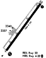
| A81-APT | ACTVT MALSR RWY 04; REIL RWY 22; HIRL RWY 04/22; TWY LGTS - CTAF. VASI RWY 22 OPR CONSLY. |
Runways
Runway Summary
| Runways: | 04/22 |
| Longest Runway: | 04/22 is 7003 ft (2135 m) long |
| Runways with an Instrument Approach: | 04 |
LWB Airport Runway Details
| Runway 04/22 | 7003 ft x 150 ft (2135 m x 46 m) | |
| Runway Length Source: | 3RD PARTY SURVEY as of 11/18/2016 | |
| Surface: | Asphalt - Good condition - Saw-cut or plastic grooved | |
| Runway Pavement Class: | 52 /F/D/X/U | |
| Runway Edge Lights: | High Intensity | |
Runway Weight Bearing Capacity (in thousands of pounds) |
||
| Single Wheel Landing Gear: | 90.0 | |
| Dual Wheel Landing Gear: | 120.0 | |
| Dual Tandem Wheel Landing Gear: | 160.0 | |
Runway 04 |
Runway 22 |
|
Elevation: |
2287.3 | 2292.5 |
Latitude: |
37-51-01.6516N | 37-51-58.1551N |
Longitude: |
080-24-23.3551W | 080-23-32.9128W |
|
Runway True Alignment: |
035 | 215 |
ILS Type: |
ILS | |
Glide Path Angle: |
0.0 degrees | 0.0 degrees |
Traffic Pattern: |
Left | Left |
Runway Markings Type: |
Precision Instrument | Nonprecision Instrument |
Runway Markings Condition: |
Good | Good |
Approach Light System: |
1,400 Foot Medium Intensity Approach Lighting System With Runway Alignment Indicator Lights | |
REIL: |
Yes | |
Declared Distances |
||
Take Off Run Avbl. (TORA): |
7003 | 7003 |
Take Off Distance Avbl. (TODA): |
7003 | 7003 |
Actual Stop Dist. Avbl. (ASDA): |
7003 | 7003 |
Landing Dist. Avbl. (LDA): |
7003 | 7003 |
Services
Airframe Repair: |
Major |
Powerplant Repair: |
Major |
Bottled Oxygen: |
None |
Bulk Oxygen: |
None |
Fuel Available: |
100LL, Jet A-1+ |
Landing Fees: |
No |
Parking: |
Tiedowns available |
Maps & Diagrams
LWB Sectional
Flight Planning
at skyvector.com
at skyvector.com