Location
Latitude: |
43-52-45.3564N (43.879266) |
Longitude: |
091-15-23.8810W (-91.256634) |
Elevation: |
655.4 feet MSL (200 m MSL) |
Magnetic Variation: |
1.6 W (as of April 2024 from WMM2020 model) |
Time Zone: |
UTC -6.0 (Standard Time) UTC -5.0 (Daylight Savings Time) |
From City: |
04 N.M. NW of La Crosse, Wisconsin |
Found On: |
Chicago Chart |
FAA Region: |
AGL |
Contacts
Manager: |
Publicly owned: |
| LAUREN KOSS 2850 AIRPORT ROAD LA CROSSE, WI 54603-1264 608-789-7466 |
CITY OF LA CROSSE 2850 AIRPORT ROAD LA CROSSE, WI 54603 608-789-7464 |
Operations
Airport Status: |
Operational |
Facility Use: |
Public |
Type: |
Airport |
Activation Date: |
02/1938 |
Control tower: |
Yes |
Attendance (Months/Days/Hours): |
Months/Days/Hours ALL/ALL/0600-2100 |
Boundary ARTCC: |
ZMP (Minneapolis) |
Responsible ARTCC: |
ZMP (Minneapolis) |
Lighting Schedule: |
SEE RMK |
Segmented Circle Indicator: |
Yes |
Traffic Pattern Altitude (MSL): |
1655 feet (504 m) |
NOTAMs Facility: |
LSE |
NOTAM-D Service: |
Yes |
International Airport of Entry: |
No |
Customs Landing Rights: |
No |
Military Landing Rights: |
Yes |
Civil/Military Joint Use: |
No |
Aircraft Rescue and Firefighting: |
Class I ARFF Index: B Air Carrier Service: Scheduled Certification Date: 05/1973 |
Based Aircraft
| Single Engine: | 49 |
| Multi Engine: | 5 |
| Jet Engine: | 8 |
| Gliders: | 1 |
Annual Operations (as of 12/31/2022)
| Total Operations: | 18143 | |
| Commercial: | 329 | 1.8% |
| Air Taxi: | 4480 | 24.7% |
| GA Local: | 3811 | 21.0% |
| GA Itinerant: | 8871 | 48.9% |
| Military Aircraft: | 652 | 3.6% |
Communications
| CTAF: | 118.450 |
| Unicom: | 122.950 |
| Tower: | LA CROSSE 118.45 251.075 Hrs: 0600-2100 |
| Ground: | 121.8 |
| Approach: | MINNEAPOLIS ARTCC |
| Departure: | MINNEAPOLIS ARTCC |
| ATIS: | 124.95 Hrs: 24 |
| ASOS: | 124.95 (608-781-9067) |
- APCH/DEP SVC PRVDD BY MINNEAPOLIS ARTCC ON FREQS 128.6/363.0 (LA CROSSE RCAG).
Fixed Based Operators (FBOs) & Fuel
(Click on a business for detail)
Please help us keep this information up to date. This is a FREE SERVICE just like everything else on Airport Guide! If you see that a business needs to be added, modified, or deleted please fill out our Update Form.
To add, modify, or delete a business click here.
Please help us keep this information up to date. This is a FREE SERVICE just like everything else on Airport Guide! If you see that a business needs to be added, modified, or deleted please fill out our Update Form.
Area Code: 608 |
| Business Name | Frequency | Phone | Fuel Grade |
|---|---|---|---|
| Colgan Air Services
Update FBO info |
Unicom 122.95 | 783-8359 | 100LL, Jet A |
Flight Service Stations
| Primary | Alternate | |
| FSS on Field: | ||
| FSS Name (ID): | Green Bay(GRB) | |
| Frequency: | ||
| Toll Free Phone: | 1-800-WX-BRIEF |
Instrument Procedures / Charts
FAA Terminal Procedures valid from 0901Z 03/21/24 to 0901Z 04/18/24.
There are various types of charts available for an airport. They are listed in the Page Type column. Here is a legend for those types:
APD - Airport Diagram
DP - Departure Procedure Charts
HOT - Hot Spots
IAP - Instrument Approach Procedure Charts
MIN - Minimums
STAR - Standard Terminal Arrival Charts
| Page Type | Page Name | Volume | Action Since Last Cycle |
|---|---|---|---|
| APD | AIRPORT DIAGRAM | EC-3 | |
| HOT | HOT SPOT | EC-3 | |
| IAP | ILS OR LOC RWY 18 | EC-3 | |
| IAP | RNAV (GPS) RWY 04 | EC-3 | |
| IAP | RNAV (GPS) RWY 13 | EC-3 | |
| IAP | RNAV (GPS) RWY 18 | EC-3 | |
| IAP | RNAV (GPS) RWY 22 | EC-3 | |
| IAP | RNAV (GPS) RWY 31 | EC-3 | |
| IAP | RNAV (GPS) RWY 36 | EC-3 | |
| MIN | ALTERNATE MINIMUMS | EC-3 | |
| MIN | TAKEOFF MINIMUMS | EC-3 |
Terminal Procedures are only available for airports in several countries with more being added all the time. If you are looking for a specific country's charts, please send an email to support(at)airportguide.com stating the country name. This will be used to prioritize the implementation.
Navigation Aids (Navaids) near LSE
| Dist (NM) | ID | Morse Code | Name | Type | Freq | True Hdg | Mag Hdg |
|---|---|---|---|---|---|---|---|
| 0.2 | LSE | . _ . . . . . . | La Crosse | DME | 108.4 | 171 | 173 |
| 7.5 | LS | . _ . . . . . | Mindi | NDB | 272 | 358 | 360 |
| 9.3 | ODI | _ _ _ _ . . . . | Nodine | VORTAC | 117.90 | 282 | 284 |
| 17.6 | ON | _ _ _ _ . | Bolln | NDB | 264 | 301 | 302 |
| 22.7 | ONA | _ _ _ _ . . _ | Winona | VOR-DME | 111.40 | 301 | 302 |
| 26.8 | CMY | _ . _ . _ _ _ . _ _ | Mccoy | NDB | 412 | 82 | 84 |
| 28.6 | BCK | _ . . . _ . _ . _ . _ | Black River Falls | NDB | 362 | 37 | 39 |
| 38.0 | UKN | . . _ _ . _ _ . | Waukon | DME | 116.6 | 198 | 199 |
| 42.2 | HBW | . . . . _ . . . . _ _ | Kickapoo | NDB | 251 | 108 | 110 |
| 43.3 | VOK | . . . _ _ _ _ _ . _ | Volk | TACAN | 110.40 | 84 | 86 |
| 48.9 | CJJ | _ . _ . . _ _ _ . _ _ _ | Cresco | NDB | 293 | 231 | 232 |
| 51.7 | VIQ | . . . _ . . _ _ . _ | Neillsville | NDB | 368 | 37 | 39 |
| 58.3 | RST | . _ . . . . _ | Rochester | VOR-DME | 112.00 | 264 | 265 |
| 60.1 | LNR | . _ . . _ . . _ . | Lone Rock | DME | 116.05 | 125 | 127 |
| 61.8 | EAU | . . _ . . _ | Eau Claire | VORTAC | 113.65 | 351 | 353 |
| 63.0 | DU | _ . . . . _ | Calin | NDB | 266 | 48 | 50 |
| 63.3 | EK | . _ . _ | Nepco | NDB | 326 | 68 | 70 |
| 64.1 | EA | . . _ | Maggs | NDB | 239 | 355 | 357 |
| 64.8 | MFI | _ _ . . _ . . . | Marshfield | NDB | 391 | 44 | 46 |
| 67.6 | ISW | . . . . . . _ _ | Wisconsin Rapids | NDB | 215 | 64 | 66 |
Nearby Airports with Fuel
Notices to Airmen (NOTAMS)
Remarks
| A110-1 | TOWER, 1390 FT AGL 6NM SW. |
| A110-10 | 48 HR PPR FOR UNSKED ACR OPS GTR THAN 30 PAX SEATS, CALL AMGR. |
| A110-2 | NUMEROUS TOWERS UP TO 836 FT AGL; 4NM SE. |
| A110-3 | DEER; WATERFOWL & OTHER BIRDS ON & INVOF ARPT. HVY CONCENTRATIONS OF WATERFOWL SPRING & FALL. |
| A110-4 | HLDG PSN FOR THE WEST SIDE OF RWY 36 APCH END IS SET BACK ON TWY C. SEE HS-1 ON ARPT DIAGRAM. |
| A110-5 | COLD TEMPERATURE AIRPORT. ALTITUDE CORRECTION REQUIRED AT OR BELOW -22C. |
| A110-6 | RWY INCURSION RISK. PILOTS ARE REMINDED TO REVIEW ARPT HOT SPOT INFO BFR TXG FOR DEP AND BFR LNDG. SEE TPP ARPT DIAGRAM AND CHART SUPPL SXN ON HOT SPOTS FOR ADDNL INFO. |
| A110-7 | WRONG RWY ARRIVAL RISK, RWY 4 AND 36 APCH ENDS ARE CLOSELY ALIGNED. SEE TPP ARPT DIAGRAM. |
| A110-8 | FOR CD WHEN ATCT IS CLSD CTC ON FSS ON RCO FREQ; IF UNA CTC MINNEAPOLIS ARTCC AT 651-463-5588. |
| A110-9 | TWY A BTN RWY 13/31 AND TWY A4; TWY A4 NOT AVBL FOR SKEDD ACR OPNS WITH MORE THAN 9 PAX SEATS OR UNSKED ACR OPNS GTR THAN 30 PAX SEATS. |
| A17 | FOR ATTENDANT OTHER HOURS CALL 608-783-8359. |
| A30-04/22 | RWY 4/22 NOT AVBL FOR SKEDD ACR OPNS WITH MORE THAN 9 PAX SEATS OR UNSKEDD ACR AT LEAST 31 PAX SEATS. |
| A43-31 | VASI UNUSBL BYD 9 DEGS RIGHT OF CNTRLN. |
| A57-31 | RWY 31 APCH RATIO 24:1 AT DSPLCD THLD. |
| A57-36 | RY 36 APCH RATIO 50:1 AT DSPLCD THLD. |
| A81-APT | WHEN ATCT CLSD MIRL RWY 13/31 PRESET LOW INTST; TO INCR INTST & ACTVT MALSR RWY 18; REIL RWY 13, 31, 36; MIRL RWY 13/31; HIRL RWY 18/36, RWY 04/22 - CTAF. PAPI RWY 04, 18, & 22; VASI RWY 13, 31, & 36 OPR CONSLY. |
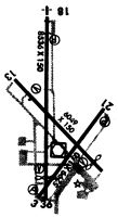
Runways
Runway Summary
| Runways: | 04/22 13/31 18/36 |
| Longest Runway: | 18/36 is 8742 ft (2665 m) long |
| Runways with an Instrument Approach: | 18 |
LSE Airport Runway Details
| Runway 04/22 | 5199 ft x 150 ft (1585 m x 46 m) | |
| Runway Length Source: | 3RD PARTY SURVEY as of 07/17/2020 | |
| Surface: | Asphalt - Fair condition - No special surface treatment | |
| Runway Pavement Class: | 47 /F/C/W/T | |
| Runway Edge Lights: | High Intensity | |
Runway Weight Bearing Capacity (in thousands of pounds) |
||
| Single Wheel Landing Gear: | 65.0 | |
| Dual Wheel Landing Gear: | 110.0 | |
| Dual Tandem Wheel Landing Gear: | 190.0 | |
Runway 04 |
Runway 22 |
|
Elevation: |
646.6 | 653.3 |
Latitude: |
43-52-12.6711N | 43-52-54.0094N |
Longitude: |
091-15-34.5055W | 091-14-52.4119W |
|
Runway True Alignment: |
036 | 216 |
Glide Path Angle: |
4.0 degrees | 4.0 degrees |
Traffic Pattern: |
Left | Left |
Runway Markings Type: |
Nonprecision Instrument | Nonprecision Instrument |
Runway Markings Condition: |
Fair | Fair |
Object at End: |
POLE | TREES |
Object Height: |
47 | 43 |
Distance from End: |
1516 | 994 |
Object Centerline Offset: |
320 ft. left of centerline | 350 ft. right of centerline |
Visual Glide Slope Indicators: |
4-Light PAPI On Left Side Of Runway | 4-Light PAPI On Left Side Of Runway |
REIL: |
No | No |
Touchdown Lights: |
No | No |
Centerline Lights: |
No | No |
Threshold Crossing Height: |
29 | 28 |
Declared Distances |
||
Take Off Run Avbl. (TORA): |
5199 | 5199 |
Take Off Distance Avbl. (TODA): |
5199 | 5199 |
Actual Stop Dist. Avbl. (ASDA): |
5199 | 5199 |
Landing Dist. Avbl. (LDA): |
5199 | 5199 |
| Runway 13/31 | 6050 ft x 150 ft (1844 m x 46 m) | |
| Runway Length Source: | 3RD PARTY SURVEY as of 07/17/2020 | |
| Surface: | Asphalt - Fair condition - Saw-cut or plastic grooved | |
| Runway Pavement Class: | 73 /R/B/W/T | |
| Runway Edge Lights: | Medium Intensity | |
Runway Weight Bearing Capacity (in thousands of pounds) |
||
| Single Wheel Landing Gear: | 125.0 | |
| Dual Wheel Landing Gear: | 190.0 | |
| Dual Tandem Wheel Landing Gear: | 430.0 | |
Runway 13 |
Runway 31 |
|
Elevation: |
655.4 | 650.5 |
Latitude: |
43-53-06.1996N | 43-52-24.4252N |
Longitude: |
091-15-51.5298W | 091-14-52.4811W |
|
Runway True Alignment: |
134 | 314 |
Glide Path Angle: |
3.0 degrees | 3.9 degrees |
Traffic Pattern: |
Left | Left |
Runway Markings Type: |
Nonprecision Instrument | Nonprecision Instrument |
Runway Markings Condition: |
Good | Good |
Object at End: |
TREES | TREES |
Object Height: |
68 | 40 |
Distance from End: |
1995 | 1250 |
Object Centerline Offset: |
320 ft. left of centerline | 350 ft. right of centerline |
Visual Glide Slope Indicators: |
4-Box VASI On Left Side Of Runway | 4-Box VASI On Left Side Of Runway |
REIL: |
Yes | Yes |
Touchdown Lights: |
No | No |
Centerline Lights: |
No | No |
Threshold Crossing Height: |
33 | 44 |
Threshold Elevation: |
652.9 | |
Displaced Threshold: |
739 | |
Threshold Latitude: |
43-52-29.5315N | |
Threshold Longitude: |
091-14-59.6970W | |
Declared Distances |
||
Take Off Run Avbl. (TORA): |
5310 | 6050 |
Take Off Distance Avbl. (TODA): |
5310 | 6050 |
Actual Stop Dist. Avbl. (ASDA): |
5310 | 6050 |
Landing Dist. Avbl. (LDA): |
5310 | 5310 |
| Runway 18/36 | 8742 ft x 150 ft (2665 m x 46 m) | |
| Runway Length Source: | 3RD PARTY SURVEY as of 07/17/2020 | |
| Surface: | Asphalt - Fair condition - Saw-cut or plastic grooved | |
| Runway Pavement Class: | 62 /R/B/W/T | |
| Runway Edge Lights: | High Intensity | |
Runway Weight Bearing Capacity (in thousands of pounds) |
||
| Single Wheel Landing Gear: | 125.0 | |
| Dual Wheel Landing Gear: | 190.0 | |
| Dual Tandem Wheel Landing Gear: | 430.0 | |
| Dual Dual Tandem Wheel Landing Gear: | 850.0 | |
Runway 18 |
Runway 36 |
|
Elevation: |
652.5 | 647.2 |
Latitude: |
43-53-35.6985N | 43-52-09.3674N |
Longitude: |
091-15-31.9495W | 091-15-30.8052W |
|
Runway True Alignment: |
179 | 359 |
ILS Type: |
ILS | |
Glide Path Angle: |
3.0 degrees | 3.0 degrees |
Traffic Pattern: |
Left | Left |
Runway Markings Type: |
Precision Instrument | Precision Instrument |
Runway Markings Condition: |
Good | Good |
Object at End: |
TREE | TREE |
Object Height: |
69 | 48 |
Distance from End: |
3443 | 1522 |
Object Centerline Offset: |
320 ft. left of centerline | 350 ft. right of centerline |
Visual Glide Slope Indicators: |
4-Light PAPI On Left Side Of Runway | 4-Box VASI On Left Side Of Runway |
Approach Light System: |
1,400 Foot Medium Intensity Approach Lighting System With Runway Alignment Indicator Lights | |
REIL: |
No | Yes |
Touchdown Lights: |
No | No |
Centerline Lights: |
No | No |
Threshold Crossing Height: |
55 | 28 |
Threshold Elevation: |
648.0 | |
Displaced Threshold: |
1131 | |
Threshold Latitude: |
43-52-20.5388N | |
Threshold Longitude: |
091-15-30.9535W | |
Declared Distances |
||
Take Off Run Avbl. (TORA): |
8105 | 8742 |
Take Off Distance Avbl. (TODA): |
8742 | 8742 |
Actual Stop Dist. Avbl. (ASDA): |
8536 | 8564 |
Landing Dist. Avbl. (LDA): |
8536 | 7433 |
Services
Airframe Repair: |
Major |
Powerplant Repair: |
Major |
Bottled Oxygen: |
None |
Bulk Oxygen: |
None |
Fuel Available: |
100LL, Jet A |
Landing Fees: |
No |
Parking: |
Hangars and tiedowns available |
Maps & Diagrams
LSE Sectional
Flight Planning
at skyvector.com
at skyvector.com