Location
Latitude: |
60-47-25.2000N (60.790333) |
Longitude: |
161-26-37.3000W (-161.443694) |
Elevation: |
25.3 feet MSL (8 m MSL) |
Magnetic Variation: |
10 E (as of April 2024 from WMM2020 model) |
Time Zone: |
UTC -9.0 (Standard Time) UTC -8.0 (Daylight Savings Time) |
From City: |
01 N.M. SSW of Kwethluk, Alaska |
Found On: |
Mc Grath Chart |
FAA Region: |
AAL |
Contacts
Manager: |
Publicly owned: |
| JOSEPH LARAUX PO BOX 505 BETHEL, AK 99559 (907) 543-2498 |
ALASKA DOT&PF CENTRAL REGION PO BOX 196900 ANCHORAGE, AK 99519-6900 907-269-0749 |
Operations
Airport Status: |
Operational |
Facility Use: |
Public |
Type: |
Airport |
Activation Date: |
07/1966 |
Control tower: |
No |
Attendance (Months/Days/Hours): |
Months/Days/Hours Unattended |
Boundary ARTCC: |
ZAN (Anchorage) |
Responsible ARTCC: |
ZAN (Anchorage) |
Lighting Schedule: |
SEE RMK |
Segmented Circle Indicator: |
Yes |
Traffic Pattern Altitude (MSL): |
1025 feet (312 m) |
NOTAMs Facility: |
KWT |
NOTAM-D Service: |
Yes |
International Airport of Entry: |
No |
Customs Landing Rights: |
No |
Military Landing Rights: |
Yes |
Civil/Military Joint Use: |
No |
Based Aircraft
Annual Operations (as of 12/31/2022)
| Total Operations: | 1200 | |
| Air Taxi: | 1200 | 100.0% |
Communications
| CTAF: | 122.900 |
| AWOS-3P: | 120.000 (907-868-7313) |
- APCH/DEP SVC PRVDD BY ANCHORAGE ARTCC IN FREQS 125.2/ 372.0 (BETHEL RCAG).
Fixed Based Operators (FBOs) & Fuel
(Click on a business for detail)
Please help us keep this information up to date. This is a FREE SERVICE just like everything else on Airport Guide! If you see that a business needs to be added, modified, or deleted please fill out our Update Form.
To add, modify, or delete a business click here.
Please help us keep this information up to date. This is a FREE SERVICE just like everything else on Airport Guide! If you see that a business needs to be added, modified, or deleted please fill out our Update Form.
Area Code: 907 |
| Business Name | Frequency | Phone | Fuel Grade |
|---|
Flight Service Stations
| Primary | Alternate | |
| FSS on Field: | N | |
| FSS Name (ID): | Kenai(ENA) | |
| Frequency: | ||
| Toll Free Phone: | 1-866-864-1737 |
Instrument Procedures / Charts
FAA Terminal Procedures valid from 0901Z 03/21/24 to 0901Z 04/18/24.
There are various types of charts available for an airport. They are listed in the Page Type column. Here is a legend for those types:
APD - Airport Diagram
DP - Departure Procedure Charts
HOT - Hot Spots
IAP - Instrument Approach Procedure Charts
MIN - Minimums
STAR - Standard Terminal Arrival Charts
| Page Type | Page Name | Volume | Action Since Last Cycle |
|---|---|---|---|
| DP | BETHEL TWO (RNAV) | AK-1 | |
| IAP | RNAV (GPS) RWY 18 | AK-1 | |
| IAP | RNAV (GPS) RWY 36 | AK-1 | |
| MIN | TAKEOFF MINIMUMS | AK-1 |
Terminal Procedures are only available for airports in several countries with more being added all the time. If you are looking for a specific country's charts, please send an email to support(at)airportguide.com stating the country name. This will be used to prioritize the implementation.
Navigation Aids (Navaids) near KWT
| Dist (NM) | ID | Morse Code | Name | Type | Freq | True Hdg | Mag Hdg |
|---|---|---|---|---|---|---|---|
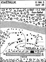
| 11.2 | BET | _ . . . . _ | Bethel | VORTAC | 114.10 | 268 | 258 |
| 12.6 | OSE | _ _ _ . . . . | Oscarville | NDB | 251 | 270 | 260 |
| 71.8 | ANI | . _ _ . . . | Aniak | NDB | 359 | 47 | 37 |
| 92.6 | SMA | . . . _ _ . _ | St Marys | NDB | 230 | 326 | 316 |
Nearby Airports with Fuel
| Dist (NM) | Name (Airport IDs) | True Hdg | Mag Hdg | Fuel Grade |
|---|---|---|---|---|
| 11.5 | Bethel Airport (BET PABE BET) |
266 | 256 | 100, 100LL, Jet A, Jet A-1 |
| 63.3 | Quinhagak Airport (KWN PAQH AQH) |
191 | 181 | 100LL |
| 72.6 | Aniak Airport (ANI PANI ANI) |
48 | 37 | 100LL, Jet A |
Notices to Airmen (NOTAMS)
Remarks
| A110*G | THIS AIRPORT HAS BEEN SURVEYED BY THE NATIONAL GEODETIC SURVEY. |
| A110-10 | WEEDS IN FRONT OF BOTH PAPI INDICATORS. |
| A110-12 | WINDSOCKS MAY BE UNRELIABLE |
| A110-2 | RY COND NOT MONITORED; RECOMMEND VISUAL INSPECTION PRIOR TO USING. |
| A110-7 | WX CAMERA AVBL ON INTERNET AT HTTPS://WEATHERCAMS.FAA.GOV |
| A110-8 | NUMEROUS ARPTS IN THE VICINITY. |
| A16 | 907-543-2498 |
| A33-18/36 | HEAVES, RUTS & EROSION CHANNELS ALONG RWY SFC. |
| A33-18/36 1 | RUTS AT RWY ENDS. |
| A40-18/36 | LGTS PARTIALLY OBSCURED BY BRUSH AND GRASS. |
| A81-APT | ACTVT MIRL RY 18/36; PAPI & REIL RYS 18 & 36 - CTAF. |
| A81-BCN | ACTVT ROTG BCN - CTAF. |
Runways
Runway Summary
| Runways: | 18/36 |
| Longest Runway: | 18/36 is 3199 ft (975 m) long |
| Runways with an Instrument Approach: |
KWT Airport Runway Details
| Runway 18/36 | 3199 ft x 75 ft (975 m x 23 m) | |
| Runway Length Source: | NGS as of 07/02/2007 | |
| Surface: | Gravel - Good condition - No special surface treatment | |
| Runway Edge Lights: | Medium Intensity | |
Runway 18 |
Runway 36 |
|
Elevation: |
25.0 | 25.0 |
Latitude: |
60-47-40.3765N | 60-47-10.0768N |
Longitude: |
161-26-28.4718W | 161-26-46.1181W |
|
Runway True Alignment: |
196 | 016 |
Glide Path Angle: |
3.0 degrees | 3.2 degrees |
Object at End: |
BRUSH | BRUSH |
Object Height: |
8 | 10 |
Distance from End: |
0 | 0 |
Object Centerline Offset: |
40 ft. right of centerline | 90 ft. left and right of centerline |
Visual Glide Slope Indicators: |
4-Light PAPI On Left Side Of Runway | 4-Light PAPI On Left Side Of Runway |
REIL: |
Yes | Yes |
Threshold Crossing Height: |
27 | 28 |
Services
Airframe Repair: |
Minor |
Powerplant Repair: |
Minor |
Fuel Available: |
100LL, Jet A |
Landing Fees: |
No |
Parking: |
Tiedowns available |
Maps & Diagrams
KWT Sectional
Flight Planning
at skyvector.com
at skyvector.com