Location
Latitude: |
39-56-07.4345N (39.935398) |
Longitude: |
086-02-42.2438W (-86.045068) |
Elevation: |
811.3 feet MSL (247 m MSL) |
Magnetic Variation: |
5.1 W (as of April 2024 from WMM2020 model) |
Time Zone: |
UTC -5.0 (Standard Time) UTC -4.0 (Daylight Savings Time) |
From City: |
08 N.M. NE of Indianapolis, Indiana |
Found On: |
St Louis Chart |
FAA Region: |
AGL |
Contacts
Manager: |
Publicly owned: |
| KEITH BERLEN 7800 COL H. WEIR COOK MEM. DRIVE, SUITE 100 INDIANAPOLIS, IN 46241-4941 (317) 487-7243 |
INDIANAPOLIS ARPT AUTH 7800 COL. H. WEIR COOK MEM. DRIVE, SUITE 100 INDIANAPOLIS, IN 46241-4941 (317) 487-7243 |
Operations
Airport Status: |
Operational |
Facility Use: |
Public |
Type: |
Airport |
Activation Date: |
11/1961 |
Control tower: |
No |
Attendance (Months/Days/Hours): |
Months/Days/Hours ALL/ALL/0800-1900 |
Boundary ARTCC: |
ZID (Indianapolis) |
Responsible ARTCC: |
ZID (Indianapolis) |
Lighting Schedule: |
SEE RMK |
Segmented Circle Indicator: |
Yes, Lighted |
Traffic Pattern Altitude (MSL): |
1811 feet (552 m) |
NOTAMs Facility: |
HUF |
NOTAM-D Service: |
Yes |
International Airport of Entry: |
No |
Customs Landing Rights: |
No |
Military Landing Rights: |
Yes |
Civil/Military Joint Use: |
No |
Based Aircraft
| Single Engine: | 116 |
| Multi Engine: | 8 |
| Jet Engine: | 6 |
| GA Helicopters: | 8 |
| Ultralights: | 1 |
Annual Operations (as of 12/31/2019)
| Total Operations: | 22842 | |
| Air Taxi: | 3883 | 17.0% |
| GA Local: | 11192 | 49.0% |
| GA Itinerant: | 7081 | 31.0% |
| Military Aircraft: | 686 | 3.0% |
Communications
| CTAF: | 123.000 |
| Unicom: | 123.000 |
| Clearance Del.: | 121.625 121.625 121.625 121.625 121.625 |
| Approach: | INDIANAPOLIS |
| Departure: | INDIANAPOLIS |
| AWOS-3PT: | 119.375 (317-842-3911) |
Fixed Based Operators (FBOs) & Fuel
(Click on a business for detail)
Please help us keep this information up to date. This is a FREE SERVICE just like everything else on Airport Guide! If you see that a business needs to be added, modified, or deleted please fill out our Update Form.
To add, modify, or delete a business click here.
Please help us keep this information up to date. This is a FREE SERVICE just like everything else on Airport Guide! If you see that a business needs to be added, modified, or deleted please fill out our Update Form.
Area Code: 317 |
| Business Name | Frequency | Phone | Fuel Grade |
|---|---|---|---|
| Indianapolis Aviation, Inc.
Update FBO info |
Unicom 123.0 | 849-0840 | 100LL, Jet A |
Flight Service Stations
| Primary | Alternate | |
| FSS on Field: | N | |
| FSS Name (ID): | Terre Haute(HUF) | |
| Frequency: | ||
| Toll Free Phone: | 1-800-WX-BRIEF |
Instrument Procedures / Charts
FAA Terminal Procedures valid from 0901Z 03/21/24 to 0901Z 04/18/24.
There are various types of charts available for an airport. They are listed in the Page Type column. Here is a legend for those types:
APD - Airport Diagram
DP - Departure Procedure Charts
HOT - Hot Spots
IAP - Instrument Approach Procedure Charts
MIN - Minimums
STAR - Standard Terminal Arrival Charts
| Page Type | Page Name | Volume | Action Since Last Cycle |
|---|---|---|---|
| APD | AIRPORT DIAGRAM | EC-2 | Changed |
| DP | DAWNN ONE | EC-2 | |
| DP | DAWNN ONE[DELIMITER] CONT.1 | EC-2 | |
| DP | HOOSIER FIVE | EC-2 | |
| DP | MAREO FIVE | EC-2 | |
| DP | MEARZ SEVEN | EC-2 | |
| DP | MEARZ SEVEN[DELIMITER] CONT.1 | EC-2 | |
| DP | ROCKY ONE | EC-2 | |
| IAP | RNAV (GPS) RWY 15 | EC-2 | Changed |
| IAP | RNAV (GPS) RWY 33 | EC-2 | Changed |
| IAP | VOR RWY 33 | EC-2 | Changed |
| MIN | TAKEOFF MINIMUMS | EC-2 | |
| STAR | RACYR SIX | EC-2 |
Terminal Procedures are only available for airports in several countries with more being added all the time. If you are looking for a specific country's charts, please send an email to support(at)airportguide.com stating the country name. This will be used to prioritize the implementation.
Navigation Aids (Navaids) near KUMP
| Dist (NM) | ID | Morse Code | Name | Type | Freq | True Hdg | Mag Hdg |
|---|---|---|---|---|---|---|---|
| 0.3 | UMP | . . _ _ _ . _ _ . | Metropolitan | NDB | 338 | 300 | 305 |
| 16.5 | VHP | . . . _ . . . . . _ _ . | Brickyard | VORTAC | 116.30 | 244 | 249 |
| 17.2 | IND | . . _ . _ . . | Indianapolis Intl | VOT | 109.60 | 224 | 229 |
| 18.3 | HFY | . . . . . . _ . _ . _ _ | Greenwood | NDB | 398 | 186 | 191 |
| 20.8 | SHB | . . . . . . . _ . . . | Shelbyville | VOR-DME | 116.15 | 150 | 155 |
| 25.8 | AI | . _ . . | Video | NDB | 394 | 71 | 76 |
| 31.1 | FKR | . . _ . _ . _ . _ . | Frankfort | NDB | 278 | 310 | 315 |
| 33.6 | UWL | . . _ . _ _ . _ . . | New Castle | NDB | 385 | 95 | 100 |
| 34.9 | MIE | _ _ . . . | Muncie | VOR-DME | 114.40 | 58 | 63 |
| 35.5 | OKK | _ _ _ _ . _ _ . _ | Kokomo | TACAN | 113.50 | 359 | 364 |
| 36.4 | JN | . _ _ _ _ . | Balll | NDB | 365 | 65 | 70 |
| 37.4 | MZZ | _ _ _ _ . . _ _ . . | Marion | VOR-DME | 108.60 | 26 | 31 |
| 37.5 | TVX | _ . . . _ _ . . _ | Greencastle | NDB | 521 | 249 | 254 |
| 38.3 | BA | _ . . . . _ | Clifs | NDB | 410 | 164 | 169 |
| 40.1 | CFJ | _ . _ . . . _ . . _ _ _ | Crawfordsville | NDB | 388 | 274 | 279 |
| 42.8 | GUS | _ _ . . . _ . . . | Grissom | VORTAC | 108.45 | 353 | 358 |
| 43.2 | SQ | . . . _ _ . _ | Pnthr | NDB | 227 | 102 | 107 |
| 50.7 | HLB | . . . . . _ . . _ . . . | Batesville | NDB | 254 | 133 | 138 |
| 51.0 | IWH | . . . _ _ . . . . | Wabash | NDB | 329 | 12 | 17 |
| 54.3 | OOM | _ _ _ _ _ _ _ _ | Hoosier | VORTAC | 110.20 | 209 | 214 |
Nearby Airports with Fuel
Notices to Airmen (NOTAMS)
Remarks
| A110-2 | OUTSIDE PHONE AVBL. |
| A110-3 | ACFT TAKEOFF/LANDING FM RY 15 DURING CALM WIND/CROSSWIND CONDITIONS; DURING ANY QUESTIONABLE PERIOD RY 15 SHALL BE PREFERRED RY - CALL AMGR 317-487-9594. |
| A110-4 | FBO PHONE NUMBER - 317-849-0840 |
| A110-5 | 500 FT AGL MOORED HOT AIR BALLOON LCTD APRXLY 4.4 MILES NORTH-NORTHWEST OF ARPT. BALLOON WILL OPER DLY FROM 1300-2200Z++ AND IS INTERNALLY ILLUMINATED. |
| A57-15 | APCH SLOPE 21:1 AT DSPLCD THR; 37 FT TREES 800 FT FM DSPLCD THR 260 FT LEFT. |
| A81-APT | ACTVT REIL RWY 15 AND 33, MIRL RWY 15/33 - CTAF. |
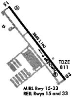
Runways
Runway Summary
| Runways: | 15/33 |
| Longest Runway: | 15/33 is 4004 ft (1220 m) long |
| Runways with an Instrument Approach: |
KUMP Airport Runway Details
| Runway 15/33 | 4004 ft x 100 ft (1220 m x 30 m) | |
| Runway Length Source: | FAA OE/AAA as of 03/26/2010 | |
| Surface: | Asphalt - Good condition - Saw-cut or plastic grooved | |
| Runway Pavement Class: | 17 /F/C/X/T | |
| Runway Edge Lights: | Medium Intensity | |
Runway Weight Bearing Capacity (in thousands of pounds) |
||
| Single Wheel Landing Gear: | 17.0 | |
Runway 15 |
Runway 33 |
|
Elevation: |
787.1 | 811.2 |
Latitude: |
39-56-23.7600N | 39-55-51.1089N |
Longitude: |
086-02-56.7600W | 086-02-27.7276W |
|
Runway True Alignment: |
146 | 326 |
Glide Path Angle: |
3.0 degrees | 3.5 degrees |
Traffic Pattern: |
Left | Left |
Runway Markings Type: |
Nonprecision Instrument | Nonprecision Instrument |
Runway Markings Condition: |
Good | Good |
Object at End: |
ROAD | |
Object Height: |
11 | |
Distance from End: |
275 | |
Object Centerline Offset: |
260 ft. right of centerline | |
Visual Glide Slope Indicators: |
4-Light PAPI On Left Side Of Runway | 4-Light PAPI On Left Side Of Runway |
REIL: |
Yes | Yes |
Threshold Crossing Height: |
43 | 27 |
Threshold Elevation: |
787.1 | |
Displaced Threshold: |
156 | |
Threshold Latitude: |
39-56-22.4888N | |
Threshold Longitude: |
086-02-55.6238W |
Services
Airframe Repair: |
Minor |
Powerplant Repair: |
Minor |
Fuel Available: |
100LL |
Landing Fees: |
No |
Parking: |
Tiedowns available |
Maps & Diagrams
KUMP Sectional
Flight Planning
at skyvector.com
at skyvector.com