Location
Latitude: |
34-44-01.5310N (34.733759) |
Longitude: |
076-39-37.2770W (-76.660355) |
Elevation: |
10.1 feet MSL (3 m MSL) |
Magnetic Variation: |
10.3 W (as of April 2024 from WMM2020 model) |
Time Zone: |
UTC -5.0 (Standard Time) UTC -4.0 (Daylight Savings Time) |
From City: |
01 N.M. N of Beaufort, North Carolina |
Found On: |
Charlotte Chart |
FAA Region: |
ASO |
Contacts
Manager: |
Publicly owned: |
| JESSE VINSON 180 AIRPORT ROAD BEAUFORT, NC 28516 252-728-1928 |
BEAUFORT-MOREHEAD ARPT AUTH 180 AIRPORT ROAD BEAUFORT, NC 28516 252-728-1928 |
Operations
Airport Status: |
Operational |
Facility Use: |
Public |
Type: |
Airport |
Activation Date: |
06/1949 |
Control tower: |
No |
Attendance (Months/Days/Hours): |
Months/Days/Hours ALL/ALL/0800-DUSK |
Boundary ARTCC: |
ZDC (Washington) |
Responsible ARTCC: |
ZDC (Washington) |
Lighting Schedule: |
SEE RMK |
Segmented Circle Indicator: |
Yes |
Traffic Pattern Altitude (MSL): |
1010 feet (308 m) |
NOTAMs Facility: |
MRH |
NOTAM-D Service: |
Yes |
International Airport of Entry: |
No |
Customs Landing Rights: |
Yes |
Military Landing Rights: |
Yes |
Civil/Military Joint Use: |
No |
Based Aircraft
| Single Engine: | 53 |
| Multi Engine: | 6 |
| Jet Engine: | 3 |
Annual Operations (as of 07/24/2021)
| Total Operations: | 43800 | |
| Air Taxi: | 3728 | 8.5% |
| GA Local: | 33549 | 76.6% |
| GA Itinerant: | 3728 | 8.5% |
| Military Aircraft: | 2795 | 6.4% |
Communications
| CTAF: | 122.800 |
| Unicom: | 122.800 |
| Clearance Del.: | 125.65 125.65 125.65 |
| Approach: | CHERRY POINT |
| Departure: | CHERRY POINT |
| ASOS: | 135.375 (252-728-2055) |
Fixed Based Operators (FBOs) & Fuel
(Click on a business for detail)
Please help us keep this information up to date. This is a FREE SERVICE just like everything else on Airport Guide! If you see that a business needs to be added, modified, or deleted please fill out our Update Form.
To add, modify, or delete a business click here.
Please help us keep this information up to date. This is a FREE SERVICE just like everything else on Airport Guide! If you see that a business needs to be added, modified, or deleted please fill out our Update Form.
Area Code: 252 |
| Business Name | Frequency | Phone | Fuel Grade |
|---|---|---|---|
| Beaufort Aviation, Inc.
Update FBO info |
Unicom 122.8 | 728-1777 | 100LL, Jet A |
Flight Service Stations
| Primary | Alternate | |
| FSS on Field: | N | |
| FSS Name (ID): | Raleigh(RDU) | |
| Frequency: | ||
| Toll Free Phone: | 1-800-WX-BRIEF |
Instrument Procedures / Charts
FAA Terminal Procedures valid from 0901Z 03/21/24 to 0901Z 04/18/24.
There are various types of charts available for an airport. They are listed in the Page Type column. Here is a legend for those types:
APD - Airport Diagram
DP - Departure Procedure Charts
HOT - Hot Spots
IAP - Instrument Approach Procedure Charts
MIN - Minimums
STAR - Standard Terminal Arrival Charts
| Page Type | Page Name | Volume | Action Since Last Cycle |
|---|---|---|---|
| IAP | RNAV (GPS) RWY 03 | SE-2 | Changed |
| IAP | RNAV (GPS) RWY 08 | SE-2 | Changed |
| IAP | RNAV (GPS) RWY 14 | SE-2 | Changed |
| IAP | RNAV (GPS) RWY 21 | SE-2 | Changed |
| IAP | RNAV (GPS) RWY 26 | SE-2 | Changed |
| IAP | RNAV (GPS) RWY 32 | SE-2 | Changed |
| MIN | ALTERNATE MINIMUMS | SE-2 | |
| MIN | TAKEOFF MINIMUMS | SE-2 |
Terminal Procedures are only available for airports in several countries with more being added all the time. If you are looking for a specific country's charts, please send an email to support(at)airportguide.com stating the country name. This will be used to prioritize the implementation.
Navigation Aids (Navaids) near KMRH
| Dist (NM) | ID | Morse Code | Name | Type | Freq | True Hdg | Mag Hdg |
|---|---|---|---|---|---|---|---|
| 0.2 | MRH | _ _ . _ . . . . . | Morehead | NDB | 269 | 217 | 227 |
| 14.6 | NKT | _ . _ . _ _ | Cherry Point | TACAN | 112.80 | 313 | 323 |
| 26.9 | EW | . . _ _ | Katfi | NDB | 362 | 310 | 320 |
| 27.8 | EWN | . . _ _ _ . | New Bern | VOR-DME | 113.60 | 317 | 327 |
| 38.5 | NCA | _ . _ . _ . . _ | New River | TACAN | 115.40 | 267 | 277 |
| 40.3 | OUC | _ _ _ . . _ _ . _ . | Pamlico/Dcmsnd | NDB-DME | 404 | 55 | 66 |
| 40.4 | DIW | _ . . . . . _ _ | Dixon | NDB | 198 | 256 | 266 |
| 51.4 | RNW | . _ . _ . . _ _ | Chocowinity | NDB | 388 | 334 | 344 |
| 51.5 | OA | _ _ _ . _ | Ellas | NDB | 261 | 271 | 281 |
| 58.4 | ISO | . . . . . _ _ _ | Kinston | VORTAC | 117.50 | 311 | 321 |
| 59.5 | IS | . . . . . | Stals | NDB | 276 | 301 | 311 |
| 61.7 | GM | _ _ . _ _ | Wilze | NDB | 205 | 247 | 257 |
| 64.2 | ILM | . . . _ . . _ _ | Wilmington | VORTAC | 117.00 | 249 | 259 |
| 64.9 | PGV | . _ _ . _ _ . . . . _ | Belvoir | FAN MARKER | 327 | 337 | |
| 65.2 | DKA | _ . . _ . _ . _ | Kenan | NDB | 332 | 288 | 298 |
| 68.0 | IL | . . . _ . . | Airli | NDB | 281 | 241 | 251 |
| 68.0 | AQE | . _ _ _ . _ . | Alwood | NDB | 230 | 329 | 339 |
| 72.1 | MCZ | _ _ _ . _ . _ _ . . | Williamston | NDB | 336 | 339 | 349 |
| 73.8 | GSB | _ _ . . . . _ . . . | Seymour Johnson | TACAN | 116.50 | 299 | 309 |
| 74.6 | CLB | _ . _ . . _ . . _ . . . | Carolina Beach | NDB | 216 | 240 | 250 |
Nearby Airports with Fuel
Notices to Airmen (NOTAMS)
Remarks
| A110-1 | NO LINE OF SIGHT BTWN RWY ENDS. |
| A110-3 | DEER AND BIRDS ON & INVOF ARPT AND BIRD-DROPPED SHELLS MAY CAUSE FOD. |
| A110-4 | NOISE ABATEMENT PROCEDURES IN EFFECT, CTC AMGR 252-728-1928. |
| A110-5 | AVOID OVERFLIGHTS OF BEAUFORT WATERFRONT AND BEAUFORT NATIONAL REGISTER HISTORIC DISTRICT. |
| A110-6 | FOR CD CTC CHERRY POINT APCH AT 252-466-5960. |
| A110-7 | MIL ACFT RWY 08/26 REQUIRED FOR NOISE ABATEMENT. |
| A110-8 | SKYDIVING OPERATIONS - DO NOT OVERFLY ARPT. |
| A110-9 | DUE TO VOLUME OF MIL TFC AND TRNG RCMD ALL ACFT USING MRH CTC CHERRY POINT APP 132.57 AB AND 125.65 PRIOR TO MRH DEP. |
| A17 | FOR SERVICE AFTER HOURS CALL 843-465-2846. |
| A52-08 | 45 FT MAST HGT. |
| A52-14 | 45 FT MAST HGT. |
| A57-03 | APCH RATIO 21:1 AT DSPLCD THR DUE TO 81 FT MAST 1938 FT FM DSPLCD THR OFFSET 748 FT L OF CNTRLN. |
| A57-08 | APCH RATIO 20:1 AT DSPLCD THR DUE TO 21 FT ROAD 627 FT FM DSPLCD THR BOTH SIDES OF CNTRLN. |
| A57-21 | APCH RATIO 22:1 AT DSPLCD THR DUE TO 76 FT TREES 1916 FT FM DSPLCD THR OFFSET 249 FT R OF CNTRLN. |
| A57-32 | APCH RATIO 13:1 AT DSPLCD THR DUE TO 61 FT TREES 995 FT FM DSPLCD THR OFFSET 85 FT R OF CNTRLN. |
| A58-03 | 9 FT FENCE 191 FT FM END OF RWY BOTH SIDES OF CNTRLN. |
| A58-08 | 7 FT BRUSH 100-200 FT FM THR OFFSET 113 FT R OF CNTRLN. |
| A58-14 | 10 FT BRUSH 0-200 FT FM THR OFFSET 171 FT R OF CNTRLN, AND 11 FT TREES 43 FT FM THR OFFSET 206 FT R OF CNTRLN. |
| A58-21 | 8 FT BRUSH 48 FT FM END OF RWY OFFSET 170 FT R OF CNTRLN. |
| A58-32 | 7 FT FENCE 121 FT FM END RWY BOTH SIDES OF CNTRLN. |
| A75 | CHECK IF HANGAR SPACE IS AVAIL W/ ARPT MAN. |
| A81-APT | ACTVT REIL RWY 08 & 26; PAPI RWY 03 & 21; MIRL RWY 03/21 & RWY 08/26 - CTAF. PAPI RWY 08 & 26 OPER CONSLY. |
| E147 | TPA: SINGLE ENGINE 1000 FT AGL, TWIN ENGINE 1500 FT AGL. |
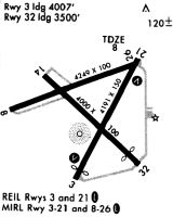
Runways
Runway Summary
| Runways: | 03/21 08/26 14/32 |
| Longest Runway: | 08/26 is 5004 ft (1525 m) long |
| Runways with an Instrument Approach: |
KMRH Airport Runway Details
| Runway 03/21 | 4192 ft x 150 ft (1278 m x 46 m) | |
| Runway Length Source: | 3RD PARTY SURVEY as of 01/03/2019 | |
| Surface: | Asphalt - Fair condition - No special surface treatment | |
| Runway Edge Lights: | Medium Intensity | |
Runway Weight Bearing Capacity (in thousands of pounds) |
||
| Single Wheel Landing Gear: | 12.5 | |
Runway 03 |
Runway 21 |
|
Elevation: |
6.0 | 6.5 |
Latitude: |
34-43-38.8682N | 34-44-16.3568N |
Longitude: |
076-39-42.8688W | 076-39-21.4185W |
|
Runway True Alignment: |
025 | 205 |
Glide Path Angle: |
4.0 degrees | 4.0 degrees |
Traffic Pattern: |
Left | Right |
Runway Markings Type: |
Nonprecision Instrument | Nonprecision Instrument |
Runway Markings Condition: |
Good | Good |
Object at End: |
ROAD | TREES |
Object Height: |
20 | 55 |
Distance from End: |
312 | 1118 |
Object Centerline Offset: |
0 ft. left and right of centerline | 137 ft. left of centerline |
Visual Glide Slope Indicators: |
2-Light PAPI On Left Side Of Runway | 2-Light PAPI On Left Side Of Runway |
REIL: |
No | No |
Threshold Crossing Height: |
44 | 54 |
Threshold Elevation: |
8.0 | 7.1 |
Displaced Threshold: |
864 | 516 |
Threshold Latitude: |
34-43-46.5947N | 34-44-11.7421N |
Threshold Longitude: |
076-39-38.4507W | 076-39-24.0533W |
| Runway 08/26 | 5004 ft x 100 ft (1525 m x 30 m) | |
| Runway Length Source: | 3RD PARTY SURVEY as of 01/03/2019 | |
| Surface: | Asphalt - Fair condition - No special surface treatment | |
| Runway Edge Lights: | Medium Intensity | |
Runway Weight Bearing Capacity (in thousands of pounds) |
||
| Dual Wheel Landing Gear: | 60.0 | |
Runway 08 |
Runway 26 |
|
Elevation: |
6.4 | 9.6 |
Latitude: |
34-43-59.2551N | 34-44-17.7712N |
Longitude: |
076-40-08.6305W | 076-39-13.0315W |
|
Runway True Alignment: |
068 | 248 |
Glide Path Angle: |
3.0 degrees | 3.0 degrees |
Traffic Pattern: |
Left | Right |
Runway Markings Type: |
Nonprecision Instrument | Nonprecision Instrument |
Runway Markings Condition: |
Good | Good |
Object at End: |
BRUSH | ROAD |
Object Height: |
12 | 20 |
Distance from End: |
321 | 325 |
Object Centerline Offset: |
0 ft. left and right of centerline | 137 ft. left of centerline |
Visual Glide Slope Indicators: |
2-Light PAPI On Left Side Of Runway | 2-Light PAPI On Right Side Of Runway |
REIL: |
Yes | Yes |
Threshold Crossing Height: |
45 | 43 |
Threshold Elevation: |
8.3 | |
Displaced Threshold: |
289 | |
Threshold Latitude: |
34-44-16.6992N | |
Threshold Longitude: |
076-39-16.2445W |
| Runway 14/32 | 4001 ft x 100 ft (1220 m x 30 m) | |
| Runway Length Source: | 3RD PARTY SURVEY as of 01/03/2019 | |
| Surface: | Asphalt - Fair condition - No special surface treatment | |
Runway Weight Bearing Capacity (in thousands of pounds) |
||
| Single Wheel Landing Gear: | 12.5 | |
Runway 14 |
Runway 32 |
|
Elevation: |
6.1 | 10.1 |
Latitude: |
34-44-10.2863N | 34-43-43.5210N |
Longitude: |
076-39-55.8694W | 076-39-20.5524W |
|
Runway True Alignment: |
133 | 313 |
Glide Path Angle: |
0.0 degrees | 0.0 degrees |
Traffic Pattern: |
Left | Left |
Runway Markings Type: |
Basic | Basic |
Runway Markings Condition: |
Good | Good |
Object at End: |
BRUSH | TREES |
Object Height: |
6 | 55 |
Distance from End: |
268 | 505 |
Object Centerline Offset: |
0 ft. left and right of centerline | 137 ft. left of centerline |
Threshold Elevation: |
9.6 | |
Displaced Threshold: |
490 | |
Threshold Latitude: |
34-43-46.8014N | |
Threshold Longitude: |
076-39-24.8751W |
Services
Airframe Repair: |
Major |
Powerplant Repair: |
Major |
Bottled Oxygen: |
None |
Bulk Oxygen: |
None |
Fuel Available: |
100LL, Jet A-1+ |
Landing Fees: |
No |
Parking: |
Tiedowns available |
Maps & Diagrams
KMRH Sectional
Flight Planning
at skyvector.com
at skyvector.com