Location
Latitude: |
31-39-57.3150N (31.665921) |
Longitude: |
098-08-55.1150W (-98.148643) |
Elevation: |
1304.8 feet MSL (398 m MSL) |
Magnetic Variation: |
3.5 E (as of April 2024 from WMM2020 model) |
Time Zone: |
UTC -6.0 (Standard Time) UTC -5.0 (Daylight Savings Time) |
From City: |
02 N.M. S of Hamilton, Texas |
Found On: |
San Antonio Chart |
FAA Region: |
ASW |
Contacts
Manager: |
Publicly owned: |
| RYAN POLSTER 200 E. MAIN HAMILTON, TX 76531 254-386-3939 |
CITY OF HAMILTON 200 E. MAIN HAMILTON, TX 76531 254-386-8116 |
Operations
Airport Status: |
Operational |
Facility Use: |
Public |
Type: |
Airport |
Activation Date: |
08/1943 |
Control tower: |
No |
Attendance (Months/Days/Hours): |
Months/Days/Hours ALL/ALL/INTMT |
Boundary ARTCC: |
ZFW (Fort Worth) |
Responsible ARTCC: |
ZFW (Fort Worth) |
Lighting Schedule: |
SEE RMK |
Segmented Circle Indicator: |
Yes |
Traffic Pattern Altitude (MSL): |
2305 feet (703 m) |
NOTAMs Facility: |
FTW |
NOTAM-D Service: |
Yes |
International Airport of Entry: |
No |
Customs Landing Rights: |
No |
Military Landing Rights: |
No |
Civil/Military Joint Use: |
No |
Based Aircraft
| Single Engine: | 12 |
| GA Helicopters: | 1 |
| Gliders: | 11 |
Annual Operations (as of 12/01/2017)
| Total Operations: | 4663 | |
| Air Taxi: | 208 | 4.5% |
| GA Local: | 1940 | 41.6% |
| GA Itinerant: | 955 | 20.5% |
| Military Aircraft: | 1560 | 33.5% |
Communications
| CTAF: | 122.700 |
| Unicom: | 122.700 |
| Approach: | GRAY 120.075 120.075 |
| Departure: | GRAY 120.075 120.075 |
| AWOS-3PT: | 118.525 (254-386-8211) |
Fixed Based Operators (FBOs) & Fuel
(Click on a business for detail)
Please help us keep this information up to date. This is a FREE SERVICE just like everything else on Airport Guide! If you see that a business needs to be added, modified, or deleted please fill out our Update Form.
To add, modify, or delete a business click here.
Please help us keep this information up to date. This is a FREE SERVICE just like everything else on Airport Guide! If you see that a business needs to be added, modified, or deleted please fill out our Update Form.
Area Code: 254 |
| Business Name | Frequency | Phone | Fuel Grade |
|---|---|---|---|
| Hansen Aviation
Update FBO info |
Unicom 122.7 | 386-3939 | 100LL, Jet A |
Flight Service Stations
| Primary | Alternate | |
| FSS on Field: | N | |
| FSS Name (ID): | Fort Worth(FTW) | |
| Frequency: | ||
| Toll Free Phone: | 1-800-WX-BRIEF |
Instrument Procedures / Charts
FAA Terminal Procedures valid from 0901Z 03/21/24 to 0901Z 04/18/24.
There are various types of charts available for an airport. They are listed in the Page Type column. Here is a legend for those types:
APD - Airport Diagram
DP - Departure Procedure Charts
HOT - Hot Spots
IAP - Instrument Approach Procedure Charts
MIN - Minimums
STAR - Standard Terminal Arrival Charts
| Page Type | Page Name | Volume | Action Since Last Cycle |
|---|---|---|---|
| IAP | RNAV (GPS) RWY 18 | SC-3 | |
| IAP | RNAV (GPS) RWY 36 | SC-3 | |
| MIN | TAKEOFF MINIMUMS | SC-3 |
Terminal Procedures are only available for airports in several countries with more being added all the time. If you are looking for a specific country's charts, please send an email to support(at)airportguide.com stating the country name. This will be used to prioritize the implementation.
Navigation Aids (Navaids) near KMNZ
| Dist (NM) | ID | Morse Code | Name | Type | Freq | True Hdg | Mag Hdg |
|---|---|---|---|---|---|---|---|
| 2.7 | MNZ | _ _ _ . _ _ . . | Hamilton | NDB | 251 | 180 | 177 |
| 28.8 | AGJ | . _ _ _ . . _ _ _ | Gooch Springs | VORTAC | 112.50 | 179 | 176 |
| 32.7 | JEN | . _ _ _ . _ . | Glen Rose | TACAN | 115.00 | 24 | 21 |
| 32.9 | GR | _ _ . . _ . | Starn | NDB | 323 | 155 | 152 |
| 39.3 | HLR | . . . . . _ . . . _ . | Hood | NDB | 347 | 145 | 142 |
| 41.7 | GRK | _ _ . . _ . _ . _ | Gray | VOR-DME | 111.80 | 155 | 152 |
| 43.4 | BWD | _ . . . . _ _ _ . . | Brownwood | VOR-DME | 113.55 | 288 | 284 |
| 44.6 | IL | . . . _ . . | Iresh | NDB | 278 | 149 | 146 |
| 44.9 | ACT | . _ _ . _ . _ | Waco | VORTAC | 115.30 | 90 | 87 |
| 46.1 | TPL | _ . _ _ . . _ . . | Temple | DME | 110.4 | 126 | 123 |
| 55.4 | OIP | _ _ _ . . . _ _ . | Old Rip | NDB | 410 | 322 | 318 |
| 55.7 | BMQ | _ . . . _ _ _ _ . _ | Burnet | NDB | 341 | 184 | 181 |
| 56.0 | ROB | . _ . _ _ _ _ . . . | Robinson | NDB | 400 | 99 | 96 |
| 61.6 | LLO | . _ . . . _ . . _ _ _ | Llano | VORTAC | 108.20 | 212 | 208 |
| 63.6 | GUO | _ _ . . . _ _ _ _ | Georgetown | NDB | 332 | 157 | 154 |
| 64.1 | MQP | _ _ _ _ . _ . _ _ . | Millsap | VORTAC | 117.70 | 6 | 3 |
| 66.9 | BBD | _ . . . _ . . . _ . . | Brady | NDB | 380 | 244 | 240 |
| 75.5 | NFW | _ . . . _ . . _ _ | Nas Jrb Fort Worth | TACAN | 108.70 | 28 | 25 |
| 79.9 | FTW | . . _ . _ . _ _ | Fort Worth | VOT | 108.20 | 29 | 26 |
| 81.9 | GNL | _ _ . _ . . _ . . | Groesbeck | DME | 108.8 | 93 | 90 |
Nearby Airports with Fuel
Notices to Airmen (NOTAMS)
Remarks
| A110-1 | GLIDER OPNS INVOF ARPT. |
| A110-2 | FOR CD CTC FORT WORTH ARTCC AT 817-858-7584. |
| A70-FUEL-10 | 0LL FUEL AVBL 24 HRS SELF-SERVE. FOR ATTENDANT AFT HRS CALL 979-571-9821. |
| A76 | GLIDER TOW AVBL. 254-386-3939 |
| A81-APT | MIRL RWY 18/36 SS-SR PRESET LOW INTST; TO INCR INTST ACTVT - CTAF. |
Runways
Runway Summary
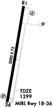
| Runways: | 18/36 |
| Longest Runway: | 18/36 is 5012 ft (1528 m) long |
| Runways with an Instrument Approach: |
KMNZ Airport Runway Details
| Runway 18/36 | 5012 ft x 75 ft (1528 m x 23 m) | |
| Runway Length Source: | STATE as of 10/02/2020 | |
| Surface: | Asphalt - Good condition - No special surface treatment | |
| Runway Edge Lights: | Medium Intensity | |
Runway Weight Bearing Capacity (in thousands of pounds) |
||
| Single Wheel Landing Gear: | 30.0 | |
Runway 18 |
Runway 36 |
|
Elevation: |
1300.0 | 1300.0 |
Latitude: |
31-40-21.8100N | 31-39-32.8200N |
Longitude: |
098-08-50.5800W | 098-08-59.6500W |
|
Runway True Alignment: |
189 | 009 |
Glide Path Angle: |
3.0 degrees | 3.0 degrees |
Traffic Pattern: |
Left | Left |
Runway Markings Type: |
Nonprecision Instrument | Nonprecision Instrument |
Runway Markings Condition: |
Good | Good |
Visual Glide Slope Indicators: |
2-Light PAPI On Left Side Of Runway | 2-Light PAPI On Left Side Of Runway |
Threshold Crossing Height: |
38 | 40 |
Services
Bulk Oxygen: |
None |
Fuel Available: |
100LL, Jet A |
Landing Fees: |
No |
Parking: |
Tiedowns available |
Maps & Diagrams
KMNZ Sectional
Flight Planning
at skyvector.com
at skyvector.com