Location
Latitude: |
38-21-59.8260N (38.366618) |
Longitude: |
085-44-17.3210W (-85.738145) |
Elevation: |
477.6 feet MSL (146 m MSL) |
Magnetic Variation: |
5.1 W (as of April 2024 from WMM2020 model) |
Time Zone: |
UTC -5.0 (Standard Time) UTC -4.0 (Daylight Savings Time) |
From City: |
05 N.M. N of Jeffersonville, Indiana |
Found On: |
St Louis Chart |
FAA Region: |
AGL |
Contacts
Manager: |
Publicly owned: |
| JOHN SECOR 6003 PROPELLER LANE SELLERSBURG, IN 47172 812-246-7460 |
SOUTH CENTRAL REGIONAL AIRPORT AUTH 6003 PROPELLER LANE SELLERSBURG, IN 47172 812-246-7460 |
Operations
Airport Status: |
Operational |
Facility Use: |
Public |
Type: |
Airport |
Activation Date: |
12/1981 |
Control tower: |
No |
Attendance (Months/Days/Hours): |
Months/Days/Hours ALL/ALL/0600-2300 |
Boundary ARTCC: |
ZID (Indianapolis) |
Responsible ARTCC: |
ZID (Indianapolis) |
Lighting Schedule: |
SEE RMK |
Segmented Circle Indicator: |
Yes |
Traffic Pattern Altitude (MSL): |
1478 feet (450 m) |
NOTAMs Facility: |
HUF |
NOTAM-D Service: |
Yes |
Military Landing Rights: |
Yes |
Based Aircraft
| Single Engine: | 120 |
| Multi Engine: | 14 |
| Jet Engine: | 32 |
| GA Helicopters: | 4 |
Annual Operations (as of 12/31/2015)
| Total Operations: | 44430 | |
| Air Taxi: | 5325 | 12.0% |
| GA Local: | 17793 | 40.0% |
| GA Itinerant: | 21312 | 48.0% |
Communications
| CTAF: | 122.700 |
| Unicom: | 122.700 |
| Approach: | LOUISVILLE |
| Departure: | LOUISVILLE |
| AWOS-3: | 118.575 (812-246-1278) |
Fixed Based Operators (FBOs) & Fuel
(Click on a business for detail)
Please help us keep this information up to date. This is a FREE SERVICE just like everything else on Airport Guide! If you see that a business needs to be added, modified, or deleted please fill out our Update Form.
To add, modify, or delete a business click here.
Please help us keep this information up to date. This is a FREE SERVICE just like everything else on Airport Guide! If you see that a business needs to be added, modified, or deleted please fill out our Update Form.
Area Code: 812 |
| Business Name | Frequency | Phone | Fuel Grade |
|---|---|---|---|
| Aircraft Specialist
Update FBO info |
Unicom 122.85 | 800-356-3723, 246-4696 | 100LL, Jet A |
| Hap's Aerial Enterprises, Inc.
Update FBO info |
Unicom 122.7 | 800-872-4277, 246-5491 | 80, 100LL, Jet A |
| WHIRL-Away Helicopters, Inc.
Update FBO info |
Unicom 122.7 | 246-5454 | 100LL, Jet A |
Flight Service Stations
| Primary | Alternate | |
| FSS on Field: | N | |
| FSS Name (ID): | Terre Haute(HUF) | |
| Frequency: | ||
| Toll Free Phone: | 1-800-WX-BRIEF |
Instrument Procedures / Charts
FAA Terminal Procedures valid from 0901Z 03/21/24 to 0901Z 04/18/24.
There are various types of charts available for an airport. They are listed in the Page Type column. Here is a legend for those types:
APD - Airport Diagram
DP - Departure Procedure Charts
HOT - Hot Spots
IAP - Instrument Approach Procedure Charts
MIN - Minimums
STAR - Standard Terminal Arrival Charts
| Page Type | Page Name | Volume | Action Since Last Cycle |
|---|---|---|---|
| IAP | ILS OR LOC RWY 18 | EC-2 | |
| IAP | NDB RWY 18 | EC-2 | |
| IAP | RNAV (GPS) RWY 18 | EC-2 | |
| IAP | RNAV (GPS) RWY 36 | EC-2 | |
| MIN | ALTERNATE MINIMUMS | EC-2 | |
| MIN | TAKEOFF MINIMUMS | EC-2 | |
| STAR | CHERI FOUR | EC-2 | |
| STAR | DARBY EIGHT | EC-2 | |
| STAR | REDSTONE SIX | EC-2 |
Terminal Procedures are only available for airports in several countries with more being added all the time. If you are looking for a specific country's charts, please send an email to support(at)airportguide.com stating the country name. This will be used to prioritize the implementation.
Navigation Aids (Navaids) near KJVY
| Dist (NM) | ID | Morse Code | Name | Type | Freq | True Hdg | Mag Hdg |
|---|---|---|---|---|---|---|---|
| 6.4 | JV | . _ _ _ . . . _ | Catch | NDB | 331 | 0 | 5 |
| 8.9 | BQM | _ . . . _ _ . _ _ _ | Bowman | DME | 112.2 | 157 | 162 |
| 10.7 | SDF | . . . _ . . . . _ . | Louisville Standifd | VOT | 111.00 | 179 | 184 |
| 14.2 | ABB | . _ _ . . . _ . . . | Nabb | VORTAC | 112.40 | 19 | 24 |
| 14.2 | LK | . _ . . _ . _ | Laang | NDB | 414 | 159 | 164 |
| 17.5 | IIU | . . . . . . _ | Louisville | VORTAC | 114.80 | 154 | 159 |
| 26.6 | GVR | _ _ . . . . _ . _ . | Hanover | DME | 114.65 | 28 | 33 |
| 26.9 | GOI | _ _ . _ _ _ . . | Godman | NDB | 396 | 204 | 209 |
| 29.7 | FTK | . . _ . _ _ . _ | Fort Knox | VOR-DME | 109.60 | 201 | 206 |
| 32.0 | EQZ | . _ _ . _ _ _ . . | Captain | NDB | 308 | 339 | 344 |
| 33.4 | BRY | _ . . . . _ . _ . _ _ | Bardstown/Dcmsnd | NDB | 248 | 158 | 163 |
| 37.1 | MYS | _ _ _ . _ _ . . . | Mystic | VOR | 108.20 | 220 | 225 |
| 40.6 | FFT | . . _ . . . _ . _ | Frankfort | VOR | 109.40 | 105 | 110 |
| 43.3 | BFR | _ . . . . . _ . . _ . | Bedford | NDB | 344 | 311 | 316 |
| 44.2 | EWO | . . _ _ _ _ _ | New Hope | VOR-DME | 113.95 | 176 | 181 |
| 49.6 | TEL | _ . . _ . . | Tell City | NDB | 206 | 245 | 250 |
| 49.9 | IKY | . . _ . _ _ . _ _ | Springfield | NDB | 429 | 151 | 156 |
| 55.7 | LE | . _ . . . | Blayd | NDB | 242 | 113 | 118 |
| 57.4 | BA | _ . . . . _ | Clifs | NDB | 410 | 356 | 361 |
| 57.8 | HNB | . . . . _ . _ . . . | Huntingburg | VOR-DME | 109.20 | 263 | 268 |
Nearby Airports with Fuel
Notices to Airmen (NOTAMS)
Remarks
| A110-2 | STUDENT ACT & WILDLIFE ON & INVOF ARPT. |
| A110-3 | LNDG FEE FOR NON BASE ACFT. |
| A110-4 | EMERG PHONE LCTD N SIDE OF AUTH BLDG - CTAF TO OPEN. |
| A110-5 | FOR CD CTC LOUISVILLE APCH AT 502-375-7499 |
| A81-APT | ACTVT MALSR RWY 18; REIL RWY 36; PAPI RWY 18 & 36 - CTAF. MIRL RWY 18/36 OPR DUSK-DAWN. RWY 14/32 LGTS PPR - 812-987-2841. |
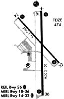
Runways
Runway Summary
| Runways: | 14/32 18/36 |
| Longest Runway: | 18/36 is 7000 ft (2134 m) long |
| Runways with an Instrument Approach: | 18 |
KJVY Airport Runway Details
| Runway 14/32 | 3899 ft x 75 ft (1188 m x 23 m) | |
| Runway Length Source: | 3RD PARTY SURVEY as of 11/11/2018 | |
| Surface: | Asphalt - Good condition - No special surface treatment | |
| Runway Edge Lights: | Medium Intensity | |
Runway Weight Bearing Capacity (in thousands of pounds) |
||
| Single Wheel Landing Gear: | 12.0 | |
Runway 14 |
Runway 32 |
|
Elevation: |
468.8 | 460.8 |
Latitude: |
38-22-14.7039N | 38-21-46.0713N |
Longitude: |
085-44-35.4078W | 085-44-02.6411W |
|
Runway True Alignment: |
138 | 318 |
Glide Path Angle: |
3.9 degrees | 3.9 degrees |
Runway Markings Type: |
Basic | Basic |
Runway Markings Condition: |
Fair | Fair |
Visual Glide Slope Indicators: |
2-Light PAPI On Left Side Of Runway | 2-Light PAPI On Left Side Of Runway |
REIL: |
Yes | Yes |
Threshold Crossing Height: |
34 | 32 |
| Runway 18/36 | 7000 ft x 100 ft (2134 m x 30 m) | |
| Runway Length Source: | 3RD PARTY SURVEY as of 08/14/2019 | |
| Surface: | Asphalt - Good condition - Saw-cut or plastic grooved | |
| Runway Edge Lights: | Medium Intensity | |
Runway Weight Bearing Capacity (in thousands of pounds) |
||
| Single Wheel Landing Gear: | 45.0 | |
| Dual Wheel Landing Gear: | 60.0 | |
Runway 18 |
Runway 36 |
|
Elevation: |
477.5 | 461.2 |
Latitude: |
38-22-34.1125N | 38-21-24.9145N |
Longitude: |
085-44-16.3914W | 085-44-16.3545W |
|
Runway True Alignment: |
180 | 360 |
ILS Type: |
ILS | |
Glide Path Angle: |
3.0 degrees | 3.0 degrees |
Runway Markings Type: |
Precision Instrument | Precision Instrument |
Runway Markings Condition: |
Good | Good |
Object at End: |
PLINE | |
Object Height: |
70 | |
Distance from End: |
3150 | |
Visual Glide Slope Indicators: |
4-Light PAPI On Left Side Of Runway | 4-Light PAPI On Left Side Of Runway |
Approach Light System: |
1,400 Foot Medium Intensity Approach Lighting System With Runway Alignment Indicator Lights | |
REIL: |
No | Yes |
Threshold Crossing Height: |
50 | 40 |
Services
Airframe Repair: |
Minor |
Powerplant Repair: |
Minor |
Fuel Available: |
100LL, Jet A+ |
Landing Fees: |
No |
Parking: |
Hangars and tiedowns available |
Maps & Diagrams
KJVY Sectional
Flight Planning
at skyvector.com
at skyvector.com