Location
Latitude: |
35-53-42.4000N (35.895111) |
Longitude: |
100-24-14.0000W (-100.403889) |
Elevation: |
2396.4 feet MSL (730 m MSL) |
Magnetic Variation: |
4.9 E (as of April 2024 from WMM2020 model) |
Time Zone: |
UTC -6.0 (Standard Time) UTC -5.0 (Daylight Savings Time) |
From City: |
02 N.M. SW of Canadian, Texas |
Found On: |
Dallas-Ft Worth Chart |
FAA Region: |
ASW |
Contacts
Manager: |
Publicly owned: |
| BILL KENDALL 255 AIRPORT ROAD - PO BOX 96 CANADIAN, TX 79014 (806) 679-4774 |
HEMPHILL COUNTY 400 MAIN STREET, SUITE 200 CANADIAN, TX 79014 806-323-6521 |
Operations
Airport Status: |
Operational |
Facility Use: |
Public |
Type: |
Airport |
Activation Date: |
07/1945 |
Control tower: |
No |
Attendance (Months/Days/Hours): |
Months/Days/Hours ALL/MON-FRI/0800-1700 |
Boundary ARTCC: |
ZAB (Albuquerque) |
Responsible ARTCC: |
ZAB (Albuquerque) |
Lighting Schedule: |
SEE RMK |
Segmented Circle Indicator: |
Yes |
Traffic Pattern Altitude (MSL): |
3396 feet (1035 m) |
NOTAMs Facility: |
HHF |
NOTAM-D Service: |
Yes |
International Airport of Entry: |
No |
Customs Landing Rights: |
No |
Military Landing Rights: |
Yes |
Civil/Military Joint Use: |
No |
Based Aircraft
| Single Engine: | 17 |
| Multi Engine: | 3 |
| Jet Engine: | 1 |
Annual Operations (as of 09/14/2021)
| Total Operations: | 9400 | |
| GA Local: | 5000 | 53.2% |
| GA Itinerant: | 4400 | 46.8% |
Communications
| CTAF: | 122.900 |
| AWOS-3: | 119.025 (806-323-8497) |
- APCH/DEP CTL SVC PRVDD BY ALBUQUERQUE ARTCC ON (ZAB) FREQS 127.85/285.475 (AMARILLO RCAG).
- AIRCRAFT EXECUTING MISSED APCH ON RNAV (GPS) RY 04 CTC KANSAS CITY ARTCC (ZKC) ON 126.95/379.2 (GAGE RCAG).
Fixed Based Operators (FBOs) & Fuel
(Click on a business for detail)
Please help us keep this information up to date. This is a FREE SERVICE just like everything else on Airport Guide! If you see that a business needs to be added, modified, or deleted please fill out our Update Form.
To add, modify, or delete a business click here.
Please help us keep this information up to date. This is a FREE SERVICE just like everything else on Airport Guide! If you see that a business needs to be added, modified, or deleted please fill out our Update Form.
Area Code: 806 |
| Business Name | Frequency | Phone | Fuel Grade |
|---|---|---|---|
| Flap-Air Helicopter Service
Update FBO info |
Unicom 122.9 | 323-8255 | 100LL |
| Great Plains Air Charter
Update FBO info |
323-5829 | ||
| Hemphill County Airport
Update FBO info |
Unicom 122.9 | 323-5326, -5521 | 100LL |
Flight Service Stations
| Primary | Alternate | |
| FSS on Field: | N | |
| FSS Name (ID): | Fort Worth(FTW) | |
| Frequency: | ||
| Toll Free Phone: | 1-800-WX-BRIEF |
Instrument Procedures / Charts
FAA Terminal Procedures valid from 0901Z 03/21/24 to 0901Z 04/18/24.
There are various types of charts available for an airport. They are listed in the Page Type column. Here is a legend for those types:
APD - Airport Diagram
DP - Departure Procedure Charts
HOT - Hot Spots
IAP - Instrument Approach Procedure Charts
MIN - Minimums
STAR - Standard Terminal Arrival Charts
| Page Type | Page Name | Volume | Action Since Last Cycle |
|---|---|---|---|
| IAP | RNAV (GPS) RWY 04 | SC-2 | |
| IAP | RNAV (GPS) RWY 22 | SC-2 | |
| MIN | ALTERNATE MINIMUMS | SC-2 | |
| MIN | TAKEOFF MINIMUMS | SC-2 |
Terminal Procedures are only available for airports in several countries with more being added all the time. If you are looking for a specific country's charts, please send an email to support(at)airportguide.com stating the country name. This will be used to prioritize the implementation.
Navigation Aids (Navaids) near KHHF
| Dist (NM) | ID | Morse Code | Name | Type | Freq | True Hdg | Mag Hdg |
|---|---|---|---|---|---|---|---|
| 33.3 | PPA | . _ _ . . _ _ . . _ | Pampa | NDB | 368 | 239 | 234 |
| 35.2 | PYX | . _ _ . _ . _ _ _ . . _ | Perryton | NDB | 266 | 331 | 326 |
| 37.0 | MMB | _ _ _ _ _ . . . | Mitbee | VORTAC | 115.60 | 43 | 38 |
| 47.9 | BGD | _ . . . _ _ . _ . . | Borger | TACAN | 108.60 | 263 | 258 |
| 49.9 | SYO | . . . _ . _ _ _ _ _ | Sayre | VORTAC | 115.20 | 131 | 126 |
| 64.4 | BZ | _ . . . _ _ . . | Fossi | NDB | 393 | 114 | 109 |
| 68.5 | MDF | _ _ _ . . . . _ . | Mooreland | NDB | 284 | 58 | 53 |
| 69.4 | BFK | _ . . . . . _ . _ . _ | Buffalo | NDB | 215 | 32 | 27 |
| 69.5 | LB | . _ . . _ . . . | Panck | NDB | 383 | 337 | 332 |
| 70.5 | BFV | _ . . . . . _ . . . . _ | Burns Flat | VORTAC | 110.00 | 123 | 118 |
| 72.1 | GUY | _ _ . . . _ _ . _ _ | Guymon | NDB | 275 | 312 | 307 |
| 74.2 | LBL | . _ . . _ . . . . _ . . | Liberal | TACAN | 112.30 | 338 | 333 |
| 74.6 | PNH | . _ _ . _ . . . . . | Panhandle | VORTAC | 116.60 | 238 | 233 |
| 81.9 | AM | . _ _ _ | Pande | NDB | 251 | 237 | 232 |
| 89.3 | HQG | . . . . _ _ . _ _ _ . | Hugoton | NDB | 365 | 328 | 323 |
| 90.0 | HBR | . . . . _ . . . . _ . | Hobart | VORTAC | 111.80 | 132 | 128 |
| 91.7 | CDS | _ . _ . _ . . . . . | Childress | VORTAC | 117.00 | 176 | 171 |
| 92.4 | LTS | . _ . . _ . . . | Altus | VORTAC | 109.80 | 142 | 137 |
| 97.5 | EHA | . . . . . . _ | Elkhart | NDB | 377 | 313 | 308 |
Nearby Airports with Fuel
Notices to Airmen (NOTAMS)
Remarks
| A110-1 | 15 FT DITCH NORTH OF RY 04 THLD EXTENDING 1000 FT ALONG LEFT SIDE OF RY. |
| A110-3 | FOR CD CTC ALBUQUERQUE ARTCC AT 505-856-4861. |
| A13 | COUNTY COURTHOUSE |
| A16 | 24 HR CONTACT 806-679-4774 |
| A57-18 | APCH SLOPE 31:1 AT DSPLCD THR. |
| A81-APT | DUSK-DAWN. MIRL RY 04/22 AND RY 18/36 PRESET LOW INTST; TO INCR INTST ACTVT - CTAF. |
Runways
Runway Summary
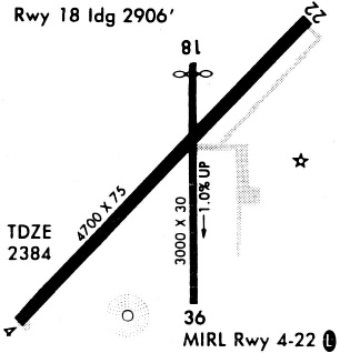
| Runways: | 04/22 18/36 |
| Longest Runway: | 04/22 is 5004 ft (1525 m) long |
| Runways with an Instrument Approach: |
KHHF Airport Runway Details
| Runway 04/22 | 5004 ft x 75 ft (1525 m x 23 m) | |
| Runway Length Source: | STATE as of 11/20/2014 | |
| Surface: | Asphalt - Excellent condition - No special surface treatment | |
| Runway Edge Lights: | Medium Intensity | |
Runway Weight Bearing Capacity (in thousands of pounds) |
||
| Single Wheel Landing Gear: | 30.0 | |
Runway 04 |
Runway 22 |
|
Elevation: |
2387.4 | 2375.6 |
Latitude: |
35-53-24.5300N | 35-53-59.8800N |
Longitude: |
100-24-37.1300W | 100-23-54.5700W |
|
Runway True Alignment: |
044 | 224 |
Glide Path Angle: |
3.0 degrees | 3.0 degrees |
Traffic Pattern: |
Left | Right |
Runway Markings Type: |
Nonprecision Instrument | Nonprecision Instrument |
Runway Markings Condition: |
Good | Good |
Object at End: |
FENCE | TREES |
Object Height: |
8 | 46 |
Distance from End: |
390 | 1417 |
Object Centerline Offset: |
0 ft. left and right of centerline | 0 ft. left and right of centerline |
Visual Glide Slope Indicators: |
2-Light PAPI On Left Side Of Runway | 2-Light PAPI On Left Side Of Runway |
REIL: |
Yes | Yes |
Threshold Crossing Height: |
38 | 35 |
| Runway 18/36 | 3001 ft x 60 ft (915 m x 18 m) | |
| Runway Length Source: | NGS as of 10/19/2008 | |
| Surface: | Asphalt - Excellent condition - No special surface treatment | |
| Runway Edge Lights: | Medium Intensity | |
Runway Weight Bearing Capacity (in thousands of pounds) |
||
| Single Wheel Landing Gear: | 12.5 | |
Runway 18 |
Runway 36 |
|
Elevation: |
2367.6 | 2396.4 |
Latitude: |
35-53-57.6095N | 35-53-28.0668N |
Longitude: |
100-24-09.1461W | 100-24-12.4978W |
|
Runway True Alignment: |
185 | 005 |
Glide Path Angle: |
0.0 degrees | 0.0 degrees |
Traffic Pattern: |
Right | Left |
Runway Markings Type: |
Basic | Basic |
Runway Markings Condition: |
Good | Good |
Object at End: |
ROAD | FENCE |
Object Height: |
10 | 6 |
Distance from End: |
210 | 212 |
Object Centerline Offset: |
0 ft. left and right of centerline | 0 ft. left and right of centerline |
Threshold Elevation: |
2368.4 | |
Displaced Threshold: |
100 | |
Threshold Latitude: |
35-53-56.6248N | |
Threshold Longitude: |
100-24-09.2569W |
Services
Fuel Available: |
100LL |
Landing Fees: |
No |
Parking: |
Tiedowns available |
Maps & Diagrams
KHHF Sectional
Flight Planning
at skyvector.com
at skyvector.com