Location
Latitude: |
44-44-04.4580N (44.734572) |
Longitude: |
103-51-42.5130W (-103.861809) |
Elevation: |
3190.6 feet MSL (972 m MSL) |
Magnetic Variation: |
7.5 E (as of April 2024 from WMM2020 model) |
Time Zone: |
UTC -7.0 (Standard Time) UTC -6.0 (Daylight Savings Time) |
From City: |
04 N.M. N of Belle Fourche, South Dakota |
Found On: |
Billings Chart |
FAA Region: |
AGL |
Contacts
Manager: |
Publicly owned: |
| JAMES DERANLEAU 10970 AIRPORT ROAD BELLE FOURCHE, SD 57717 605-892-6345 |
CITY OF BELLE FOURCHE 511 6TH AVE. BELLE FOURCHE, SD 57717 605-892-2494 |
Operations
Airport Status: |
Operational |
Facility Use: |
Public |
Type: |
Airport |
Activation Date: |
11/1986 |
Control tower: |
No |
Attendance (Months/Days/Hours): |
Months/Days/Hours ALL/ALL/0800-1800 |
Boundary ARTCC: |
ZDV (Denver) |
Responsible ARTCC: |
ZDV (Denver) |
Lighting Schedule: |
SEE RMK |
Segmented Circle Indicator: |
Yes |
Traffic Pattern Altitude (MSL): |
4191 feet (1277 m) |
NOTAMs Facility: |
HON |
NOTAM-D Service: |
Yes |
Based Aircraft
| Single Engine: | 17 |
| Multi Engine: | 1 |
Annual Operations (as of 07/25/2023)
| Total Operations: | 4206 | |
| GA Local: | 3600 | 85.6% |
| GA Itinerant: | 600 | 14.3% |
| Military Aircraft: | 6 | 0.1% |
Communications
| CTAF: | 122.800 |
| Unicom: | 122.800 |
- APCH/DEP CTL SVC PRVDD BY DENVER ARTCC (ZDV) ON FREQS 127.95/338.2 (CRAWFORD RCAG).
Fixed Based Operators (FBOs) & Fuel
(Click on a business for detail)
Please help us keep this information up to date. This is a FREE SERVICE just like everything else on Airport Guide! If you see that a business needs to be added, modified, or deleted please fill out our Update Form.
To add, modify, or delete a business click here.
Please help us keep this information up to date. This is a FREE SERVICE just like everything else on Airport Guide! If you see that a business needs to be added, modified, or deleted please fill out our Update Form.
Area Code: 605 |
| Business Name | Frequency | Phone | Fuel Grade |
|---|---|---|---|
| Belle Air Co.
Update FBO info |
Unicom 122.8 | 892-6345 | 100LL |
Flight Service Stations
| Primary | Alternate | |
| FSS on Field: | ||
| FSS Name (ID): | Huron(HON) | |
| Frequency: | ||
| Toll Free Phone: | 1-800-WX-BRIEF |
Instrument Procedures / Charts
FAA Terminal Procedures valid from 0901Z 03/21/24 to 0901Z 04/18/24.
There are various types of charts available for an airport. They are listed in the Page Type column. Here is a legend for those types:
APD - Airport Diagram
DP - Departure Procedure Charts
HOT - Hot Spots
IAP - Instrument Approach Procedure Charts
MIN - Minimums
STAR - Standard Terminal Arrival Charts
| Page Type | Page Name | Volume | Action Since Last Cycle |
|---|---|---|---|
| IAP | RNAV (GPS) RWY 32 | NC-1 | |
| MIN | TAKEOFF MINIMUMS | NC-1 |
Terminal Procedures are only available for airports in several countries with more being added all the time. If you are looking for a specific country's charts, please send an email to support(at)airportguide.com stating the country name. This will be used to prioritize the implementation.
Navigation Aids (Navaids) near KEFC
| Dist (NM) | ID | Morse Code | Name | Type | Freq | True Hdg | Mag Hdg |
|---|---|---|---|---|---|---|---|
| 15.4 | SPF | . . . . _ _ . . . _ . | Black Hills | NDB | 300 | 167 | 160 |
| 48.3 | RCA | . _ . _ . _ . . _ | Ellsworth | TACAN | 108.80 | 137 | 130 |
| 52.0 | BUA | _ . . . . . _ . _ | Buffalo | DME | 109.4 | 19 | 12 |
| 54.7 | ECS | . _ . _ . . . . | Newcastle | VOR | 108.20 | 200 | 192 |
| 58.3 | RAP | . _ . . _ . _ _ . | Rapid City | VORTAC | 112.30 | 141 | 134 |
| 59.2 | RA | . _ . . _ | Ranch | NDB | 254 | 140 | 133 |
| 75.6 | GCC | _ _ . _ . _ . _ . _ . | Gillette | VOR-DME | 114.60 | 252 | 244 |
| 76.3 | GC | _ _ . _ . _ . | Deryk | NDB | 380 | 249 | 241 |
| 78.0 | BDX | _ . . . _ . . _ . . _ | Broadus | NDB | 335 | 303 | 295 |
| 88.9 | BOD | _ . . . _ _ _ _ . . | Bowman | NDB | 374 | 11 | 4 |
| 93.5 | DPR | _ . . . _ _ . . _ . | Dupree | VOR-DME | 116.80 | 76 | 69 |
| 98.2 | BKU | _ . . . _ . _ . . _ | Timber | NDB | 344 | 350 | 342 |
Nearby Airports with Fuel
| Dist (NM) | Name (Airport IDs) | True Hdg | Mag Hdg | Fuel Grade |
|---|---|---|---|---|
| 15.6 | Black Hills-Clyde Ice Field Airport (SPF KSPF SPF) |
167 | 160 | 100LL, Jet A |
| 28.1 | Sturgis Municipal Airport (49B) |
132 | 125 | 100LL, Jet A |
| 53.8 | Rapid City Regional Airport (RAP KRAP RAP) |
139 | 132 | 100LL, Jet A |
| 54.6 | Mondell Field Airport (ECS KECS ECS) |
201 | 193 | 100LL, Jet A |
| 75.4 | Northeast Wyoming Regional Airport (GCC KGCC GCC) |
252 | 244 | 100LL, Jet A |
| 75.5 | Bison Municipal Airport (6V5) |
50 | 43 | 100LL |
| 84.5 | Hot Springs Municipal Airport (KHSR HSR) |
165 | 158 | 100LL |
| 92.1 | Hettinger/Jb Lindquist Regional Airport (KHEI HEI) |
33 | 26 | 100LL, Jet A |
| 98.1 | Baker Municipal Airport (KBHK BHK) |
350 | 342 | 100LL, Jet A+ |
Notices to Airmen (NOTAMS)
Remarks
| A110-3 | ULTRALIGHT OPNS ON & INVOF ARPT. |
| A110-4 | WATERFOWL ON AND INVOF ARPT. |
| A110-6 | FOR CD CTC DENVER ARTCC AT 303-651-4257. |
| A110-7 | HIGH VOL OF ACFT OPRNG INVOF OF MT RUSHMORE AND CRAZY HORSE MONUMENTS AT OR BLW 7500 FT; PILOTS ARE ADVISED TO MNT 122.85 FOR TFC ADVISORIES. |
| A30-18/36 | MARKED WITH WHITE/BLACK MARKER CONES. |
| A81-APT | ACTVT MIRL RWY 14/32 - CTAF. |
| A82 | AUTOMATED UNICOM. |
Runways
Runway Summary
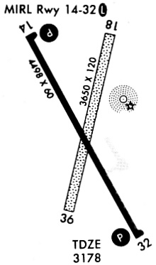
| Runways: | 14/32 18/36 |
| Longest Runway: | 14/32 is 4501 ft (1372 m) long |
| Runways with an Instrument Approach: |
KEFC Airport Runway Details
| Runway 14/32 | 4501 ft x 60 ft (1372 m x 18 m) | |
| Runway Length Source: | 3RD PARTY SURVEY as of 01/04/2021 | |
| Surface: | Asphalt - Good condition - No special surface treatment | |
| Runway Edge Lights: | Medium Intensity | |
Runway Weight Bearing Capacity (in thousands of pounds) |
||
| Single Wheel Landing Gear: | 12.5 | |
Runway 14 |
Runway 32 |
|
Elevation: |
3169.9 | 3180.1 |
Latitude: |
44-44-22.8089N | 44-43-43.4883N |
Longitude: |
103-51-57.6989W | 103-51-28.6446W |
|
Runway True Alignment: |
152 | 332 |
Glide Path Angle: |
3.0 degrees | 3.0 degrees |
Runway Markings Type: |
Nonprecision Instrument | Nonprecision Instrument |
Runway Markings Condition: |
Fair | Fair |
Visual Glide Slope Indicators: |
2-Light PAPI On Left Side Of Runway | 2-Light PAPI On Left Side Of Runway |
Threshold Crossing Height: |
40 | 33 |
| Runway 18/36 | 3639 ft x 120 ft (1109 m x 37 m) | |
| Runway Length Source: | 3RD PARTY SURVEY as of 01/04/2021 | |
| Surface: | Asphalt - Good condition - No special surface treatment | |
Runway 18 |
Runway 36 |
|
Elevation: |
3190.6 | 3189.7 |
Latitude: |
44-44-23.6379N | 44-43-48.5167N |
Longitude: |
103-51-36.3999W | 103-51-46.9990W |
|
Runway True Alignment: |
192 | 012 |
Glide Path Angle: |
0.0 degrees | 0.0 degrees |
Services
Airframe Repair: |
Major |
Powerplant Repair: |
Major |
Bottled Oxygen: |
None |
Bulk Oxygen: |
None |
Fuel Available: |
100LL, Jet A+ |
Landing Fees: |
No |
Parking: |
Hangars and tiedowns available |
Maps & Diagrams
KEFC Sectional
Flight Planning
at skyvector.com
at skyvector.com