Location
Latitude: |
56-18-41.2655N (56.311463) |
Longitude: |
158-22-23.6575W (-158.373238) |
Elevation: |
18.3 feet MSL (6 m MSL) |
Magnetic Variation: |
11.3 E (as of April 2024 from WMM2020 model) |
Time Zone: |
UTC -9.0 (Standard Time) UTC -8.0 (Daylight Savings Time) |
From City: |
02 N.M. NE of Chignik, Alaska |
Found On: |
Kodiak Chart |
FAA Region: |
AAL |
Contacts
Manager: |
Publicly owned: |
| PAUL HANSEN BOX 65 KING SALMON, AK 99613 907-246-3325 |
ALASKA DOT&PF SOUTHCOAST REGION P.O. BOX 196900 ANCHORAGE, AK 99519-6900 907-269-0760 |
Operations
Airport Status: |
Operational |
Facility Use: |
Public |
Type: |
Airport |
Activation Date: |
06/1968 |
Control tower: |
No |
Attendance (Months/Days/Hours): |
Months/Days/Hours Unattended |
Boundary ARTCC: |
ZAN (Anchorage) |
Responsible ARTCC: |
ZAN (Anchorage) |
Segmented Circle Indicator: |
Yes |
Traffic Pattern Altitude (MSL): |
1018 feet (310 m) |
NOTAMs Facility: |
AJC |
NOTAM-D Service: |
Yes |
International Airport of Entry: |
No |
Customs Landing Rights: |
No |
Military Landing Rights: |
Yes |
Civil/Military Joint Use: |
No |
Based Aircraft
Annual Operations (as of 12/31/2019)
| Total Operations: | 2120 | |
| Air Taxi: | 1420 | 67.0% |
| GA Local: | 200 | 9.4% |
| GA Itinerant: | 500 | 23.6% |
Communications
| CTAF: | 122.800 |
| AWOS-3P: | 135.75 (907-749-2402) |
Fixed Based Operators (FBOs) & Fuel
(Click on a business for detail)
Please help us keep this information up to date. This is a FREE SERVICE just like everything else on Airport Guide! If you see that a business needs to be added, modified, or deleted please fill out our Update Form.
To add, modify, or delete a business click here.
Please help us keep this information up to date. This is a FREE SERVICE just like everything else on Airport Guide! If you see that a business needs to be added, modified, or deleted please fill out our Update Form.
Area Code: 907 |
| Business Name | Frequency | Phone | Fuel Grade |
|---|
Flight Service Stations
| Primary | Alternate | |
| FSS on Field: | N | |
| FSS Name (ID): | Kenai(ENA) | |
| Frequency: | ||
| Toll Free Phone: | 1-866-864-1737 |
Instrument Procedures / Charts
Terminal Procedures are only available for airports in several countries with more being added all the time. If you are looking for a specific country's charts, please send an email to support(at)airportguide.com stating the country name. This will be used to prioritize the implementation.
Navigation Aids (Navaids) near KCG
Nearby Airports with Fuel
| Dist (NM) | Name (Airport IDs) | True Hdg | Mag Hdg | Fuel Grade |
|---|
Notices to Airmen (NOTAMS)
Remarks
| A110-2 | SEABIRDS ON AND INVOF ARPT. |
| A110-3 | RY CONDITON NOT MAINTAINED; RECOMMEND VISUAL INSPECTION PRIOR TO USE. |
| A110-4 | MOUNTAINS SW OF ARPT CREATE FREQUENT SEVERE TURBULENCE. |
| A110-6 | SEAPLANE OPERG AREA IN LAKE EAST OF ARPT. |
| A110-7 | WX CAMERA AVBL ON INTERNET AT HTTPS://WEATHERCAMS.FAA.GOV |
| A13 | 907-269-0760 |
| A42-02 | RYS 02 & 20 MKD WITH ORANGE REFLECTIVE CONES. |
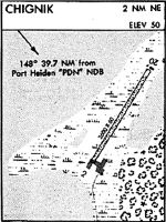
Runways
Runway Summary
| Runways: | 02/20 |
| Longest Runway: | 02/20 is 2600 ft (792 m) long |
| Runways with an Instrument Approach: |
KCG Airport Runway Details
| Runway 02/20 | 2600 ft x 60 ft (792 m x 18 m) | |
| Surface: | Gravel - Good condition - No special surface treatment | |
Runway 02 |
Runway 20 |
|
Elevation: |
16.6 | 12.4 |
Latitude: |
56-18-30.7020N | 56-18-51.8290N |
Longitude: |
158-22-36.6940W | 158-22-10.6210W |
|
Runway True Alignment: |
034 | 214 |
Glide Path Angle: |
0.0 degrees | 0.0 degrees |
Traffic Pattern: |
Left | Left |
Object at End: |
BRUSH | BERM |
Object Height: |
5 | 6 |
Distance from End: |
2 | 1 |
Object Centerline Offset: |
105 ft. right of centerline |
Services
Airframe Repair: |
None |
Powerplant Repair: |
None |
Bottled Oxygen: |
None |
Bulk Oxygen: |
None |
Landing Fees: |
No |
Parking: |
Tiedowns available |
Maps & Diagrams
KCG Sectional
Flight Planning
at skyvector.com
at skyvector.com