Location
Latitude: |
39-44-06.6000N (39.735167) |
Longitude: |
097-02-51.3000W (-97.047583) |
Elevation: |
1436.5 feet MSL (438 m MSL) |
Magnetic Variation: |
2.9 E (as of April 2024 from WMM2020 model) |
Time Zone: |
UTC -6.0 (Standard Time) UTC -5.0 (Daylight Savings Time) |
From City: |
05 N.M. S of Washington, Kansas |
Found On: |
Wichita Chart |
FAA Region: |
ACE |
Contacts
Manager: |
Publicly owned: |
| BRAD FORTENIER 303 C ST. WASHINGTON, KS 66968 (785) 747-6640 |
WASHINGTON COUNTY CO CMSNRS, WASH CO COURTHOUSE WASHINGTON, KS 66968 785-325-2974 |
Operations
Airport Status: |
Operational |
Facility Use: |
Public |
Type: |
Airport |
Activation Date: |
01/1980 |
Control tower: |
No |
Attendance (Months/Days/Hours): |
Months/Days/Hours Unattended |
Boundary ARTCC: |
ZKC (Kansas City) |
Responsible ARTCC: |
ZKC (Kansas City) |
Lighting Schedule: |
SEE RMK |
Segmented Circle Indicator: |
No |
Traffic Pattern Altitude (MSL): |
2436 feet (742 m) |
NOTAMs Facility: |
ICT |
NOTAM-D Service: |
Yes |
Based Aircraft
| Single Engine: | 3 |
Annual Operations (as of 09/19/2018)
| Total Operations: | 1700 | |
| GA Local: | 900 | 52.9% |
| GA Itinerant: | 800 | 47.1% |
Communications
| CTAF: | 122.900 |
- APCH/DEP CTL SVC PRVDD BY KANSAS CITY ARTCC (ZKC) ON FREQS 127.35/257.975 (MANHATTAN RCAG).
Fixed Based Operators (FBOs) & Fuel
(Click on a business for detail)
Please help us keep this information up to date. This is a FREE SERVICE just like everything else on Airport Guide! If you see that a business needs to be added, modified, or deleted please fill out our Update Form.
To add, modify, or delete a business click here.
Please help us keep this information up to date. This is a FREE SERVICE just like everything else on Airport Guide! If you see that a business needs to be added, modified, or deleted please fill out our Update Form.
Area Code: 785 |
| Business Name | Frequency | Phone | Fuel Grade |
|---|
Flight Service Stations
| Primary | Alternate | |
| FSS on Field: | N | |
| FSS Name (ID): | Wichita(ICT) | |
| Frequency: | ||
| Toll Free Phone: | 1-800-WX-BRIEF |
Instrument Procedures / Charts
FAA Terminal Procedures valid from 0901Z 03/21/24 to 0901Z 04/18/24.
There are various types of charts available for an airport. They are listed in the Page Type column. Here is a legend for those types:
APD - Airport Diagram
DP - Departure Procedure Charts
HOT - Hot Spots
IAP - Instrument Approach Procedure Charts
MIN - Minimums
STAR - Standard Terminal Arrival Charts
| Page Type | Page Name | Volume | Action Since Last Cycle |
|---|---|---|---|
| IAP | RNAV (GPS) RWY 17 | NC-2 | |
| IAP | RNAV (GPS) RWY 35 | NC-2 | |
| MIN | TAKEOFF MINIMUMS | NC-2 |
Terminal Procedures are only available for airports in several countries with more being added all the time. If you are looking for a specific country's charts, please send an email to support(at)airportguide.com stating the country name. This will be used to prioritize the implementation.
Navigation Aids (Navaids) near K38
| Dist (NM) | ID | Morse Code | Name | Type | Freq | True Hdg | Mag Hdg |
|---|---|---|---|---|---|---|---|
| 21.9 | CYW | _ . _ . _ . _ _ . _ _ | Clay Center | NDB | 362 | 193 | 190 |
| 27.0 | FBY | . . _ . _ . . . _ . _ _ | Fairbury | NDB | 293 | 348 | 345 |
| 28.5 | RPB | . _ . . _ _ . _ . . . | Republican | NDB | 414 | 279 | 276 |
| 29.9 | CNK | _ . _ . _ . _ . _ | Concordia | NDB | 335 | 248 | 245 |
| 35.2 | HJH | . . . . . _ _ _ . . . . | Hebron | NDB | 323 | 315 | 312 |
| 36.5 | BIE | _ . . . . . . | Beatrice | VOR | 110.60 | 21 | 18 |
| 39.5 | MHK | _ _ . . . . _ . _ | Manhattan | VOR-DME | 110.20 | 153 | 150 |
| 44.1 | CVY | _ . _ . . . . _ _ . _ _ | Cavalry | NDB | 314 | 164 | 161 |
| 46.7 | FRI | . . _ . . _ . . . | Fort Riley | VOR | 109.40 | 169 | 166 |
| 47.7 | PWE | . _ _ . . _ _ . | Pawnee City | DME | 112.4 | 53 | 50 |
| 55.4 | SLN | . . . . _ . . _ . | Salina | VORTAC | 117.10 | 208 | 205 |
| 56.1 | TKO | _ _ . _ _ _ _ | Mankato | VORTAC | 109.80 | 274 | 271 |
| 56.6 | FMZ | . . _ . _ _ _ _ . . | Beklof | NDB | 392 | 335 | 332 |
| 62.1 | LN | . _ . . _ . | Potts | NDB | 385 | 12 | 9 |
| 63.5 | HRU | . . . . . _ . . . _ | Herington | NDB | 407 | 169 | 166 |
| 67.6 | SWT | . . . . _ _ _ | Seward | NDB | 269 | 357 | 354 |
| 69.1 | SL | . . . . _ . . | Flory | NDB | 344 | 203 | 200 |
| 70.3 | FNB | . . _ . _ . _ . . . | Brenner | NDB | 404 | 72 | 70 |
| 72.7 | LNK | . _ . . _ . _ . _ | Lincoln | VORTAC | 116.10 | 10 | 7 |
| 73.0 | TO | _ _ _ _ | Biloy | NDB | 521 | 119 | 117 |
Nearby Airports with Fuel
Notices to Airmen (NOTAMS)
Remarks
| A110-1 | 24 HR PHONE AVBL FOR PUBLIC USE WITH PHONE CARD. |
| A110-2 | FOR CD CTC KANSAS CITY ARTCC AT 913-254-8508. |
| A57-17 | RWY 17 APPROACH SLOPE 34:1 TO THE DISP THLD. |
| A81-APT | ACTVT MIRL RWY 17/35 - CTAF. |
| A83 | WIND INDICATOR OTS INDEFLY. |
| E111 | E111 PRVDD THE APCH TO EACH RWY IS MAINTD FOR A MIN 20:1 GLIDE SLOPE AND THE TRANSITIONAL SFC BE MAINTD FOR A 7:1 SLOPE. |
Runways
Runway Summary
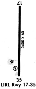
| Runways: | 17/35 |
| Longest Runway: | 17/35 is 3406 ft (1038 m) long |
| Runways with an Instrument Approach: |
K38 Airport Runway Details
| Runway 17/35 | 3406 ft x 60 ft (1038 m x 18 m) | |
| Runway Length Source: | 3RD PARTY SURVEY as of 12/08/2011 | |
| Surface: | Concrete - Good condition - No special surface treatment | |
| Runway Edge Lights: | Medium Intensity | |
Runway 17 |
Runway 35 |
|
Elevation: |
1436.5 | 1425.9 |
Latitude: |
39-44-23.4479N | 39-43-49.7901N |
Longitude: |
097-02-51.2359W | 097-02-51.4134W |
|
Runway True Alignment: |
180 | 000 |
Glide Path Angle: |
0.0 degrees | 0.0 degrees |
Traffic Pattern: |
Left | Left |
Runway Markings Type: |
Nonprecision Instrument | Nonprecision Instrument |
Runway Markings Condition: |
Good | Good |
Object at End: |
ROAD | PLINE |
Object Height: |
15 | 68 |
Object Marked/Lighted?: |
Marked | |
Distance from End: |
300 | 1562 |
Object Centerline Offset: |
0 ft. left and right of centerline | 0 ft. left and right of centerline |
Threshold Elevation: |
1435.6 | |
Displaced Threshold: |
220 | |
Threshold Latitude: |
39-44-21.2747N | |
Threshold Longitude: |
097-02-51.2482W |
Services
Fuel Available: |
100LL, Jet A |
Parking: |
Hangars and tiedowns available |
Maps & Diagrams
K38 Sectional
Flight Planning
at skyvector.com
at skyvector.com