Location
Latitude: |
59-58-08.4680N (59.969019) |
Longitude: |
141-39-42.3730W (-141.66177) |
Elevation: |
50.0 feet MSL (15 m MSL) |
Magnetic Variation: |
17.2 E (as of April 2024 from WMM2020 model) |
Time Zone: |
UTC -9.0 (Standard Time) UTC -8.0 (Daylight Savings Time) |
From City: |
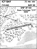
73 N.M. NW of Icy Bay, Alaska |
Found On: |
Seward Chart |
FAA Region: |
AAL |
Contacts
Manager: |
Publicly owned: |
| TRUST LAND OFFICE 2600 CORDOVA ST., SUITE 100 ANCHORAGE, AK 99503-3336 907-269-8658 |
ALASKA MENTAL HEALTH TRUST AUTH. 2600 CORDOVA ST., SUITE 100 ANCHORAGE, AK 99503 907-269-8658 |
Operations
Airport Status: |
Operational |
Facility Use: |
Private |
Type: |
Airport |
Control tower: |
No |
Attendance (Months/Days/Hours): |
Months/Days/Hours Unattended |
Boundary ARTCC: |
ZAN (Anchorage) |
Responsible ARTCC: |
ZAN (Anchorage) |
Segmented Circle Indicator: |
No |
Traffic Pattern Altitude (MSL): |
1050 feet (320 m) |
NOTAMs Facility: |
JNU |
NOTAM-D Service: |
No |
International Airport of Entry: |
No |
Customs Landing Rights: |
No |
Military Landing Rights: |
No |
Civil/Military Joint Use: |
No |
Based Aircraft
Annual Operations (as of 10/05/1991)
| Total Operations: | 550 | |
| Air Taxi: | 250 | 45.5% |
| GA Itinerant: | 300 | 54.5% |
Communications
Fixed Based Operators (FBOs) & Fuel
(Click on a business for detail)
Please help us keep this information up to date. This is a FREE SERVICE just like everything else on Airport Guide! If you see that a business needs to be added, modified, or deleted please fill out our Update Form.
To add, modify, or delete a business click here.
Please help us keep this information up to date. This is a FREE SERVICE just like everything else on Airport Guide! If you see that a business needs to be added, modified, or deleted please fill out our Update Form.
Area Code: 907 |
| Business Name | Frequency | Phone | Fuel Grade |
|---|
Flight Service Stations
| Primary | Alternate | |
| FSS on Field: | N | |
| FSS Name (ID): | Juneau(JNU) | |
| Frequency: | ||
| Toll Free Phone: | 1-866-297-2236 |
Instrument Procedures / Charts
Terminal Procedures are only available for airports in several countries with more being added all the time. If you are looking for a specific country's charts, please send an email to support(at)airportguide.com stating the country name. This will be used to prioritize the implementation.
Navigation Aids (Navaids) near ICY
| Dist (NM) | ID | Morse Code | Name | Type | Freq | True Hdg | Mag Hdg |
|---|---|---|---|---|---|---|---|
| 25.8 | CYT | _ . _ . _ . _ _ _ | Yakataga | NDB | 209 | 286 | 269 |
| 63.8 | OCC | _ _ _ _ . _ . _ . _ . | Ocean Cape | NDB | 385 | 112 | 95 |
| 66.8 | YAK | _ . _ _ . _ _ . _ | Yakutat | VOR-DME | 113.30 | 113 | 96 |
Nearby Airports with Fuel
| Dist (NM) | Name (Airport IDs) | True Hdg | Mag Hdg | Fuel Grade |
|---|---|---|---|---|
| 66.7 | Yakutat Airport (YAK PAYA YAK) |
113 | 95 | 100, Jet A-1+ |
Notices to Airmen (NOTAMS)
Remarks
| A110-1 | 50 FT TREES; 60 FT TO 100 FT EACH SIDE OF RY CENTERLINE ENTIRE LENGTH OF RY. |
| A110-2 | BULK FUEL STORAGE TANKS ON TRAILERS PARKED ON TURNOUT WITHIN 40 FT OF RY CENTERLINE. |
| A110-3 | 1 FT HIGH BERM & 2 FT DRAINAGE DITCH LENGTH OF RY EACH SIDE; 60 FT FROM CENTERLINE ON NORTH SIDE & 40 FT FROM CENTERLINE ON SOUTH SIDE. |
| A110-4 | UNCONTROLLED VEHICULAR TRAFFIC ON RY. |
| A110-5 | LAND OWNED BY ALASKA MENTAL HEALTH TRUST AUTHORITY. USE BY PERMIT OR LICENSE ONLY. CONTACT 907-269-8658. |
| A110-6 | 8 FT BERMS 500 FT E OF AER 23. |
| A14 | DAVID GRIFFIN : 907-269-7921; EMAIL: DAVID.GRIFFIN@ALASKA.GOV |
| A3 | LCTD 73 SM NW OF YAKUTAT. |
| A33-05/23 | FIRST 1000 FT RY 05 SOFT WHEN WET; RUTS ALONG EDGES & DIVITS IN VICINITY OF THR. |
| E111 | ESTABD PRIOR TO 1959. |
Runways
Runway Summary
| Runways: | 05/23 |
| Longest Runway: | 05/23 is 3430 ft (1045 m) long |
| Runways with an Instrument Approach: |
ICY Airport Runway Details
| Runway 05/23 | 3430 ft x 55 ft (1045 m x 17 m) | |
| Surface: | Gravel - Fair condition - No special surface treatment | |
Runway 05 |
Runway 23 |
|
Glide Path Angle: |
0.0 degrees | 0.0 degrees |
Traffic Pattern: |
Left | Left |
Object at End: |
TREES | TREES |
Object Height: |
70 | 55 |
Distance from End: |
700 | 240 |
Object Centerline Offset: |
150 ft. left of centerline | 80 ft. left of centerline |
Services
Airframe Repair: |
None |
Powerplant Repair: |
None |
Bottled Oxygen: |
None |
Bulk Oxygen: |
None |
Fuel Available: |
100, Jet A-1+ |
Landing Fees: |
No |
Maps & Diagrams
ICY Sectional
Flight Planning
at skyvector.com
at skyvector.com