Location
Latitude: |
39-45-54.3800N (39.765106) |
Longitude: |
084-20-34.6600W (-84.342961) |
Elevation: |
925.0 feet MSL (282 m MSL) |
Magnetic Variation: |
6.3 W (as of April 2024 from WMM2020 model) |
Time Zone: |
UTC -5.0 (Standard Time) UTC -4.0 (Daylight Savings Time) |
From City: |
07 N.M. W of Dayton, Ohio |
Found On: |
Cincinnati Chart |
FAA Region: |
AGL |
Contacts
Manager: |
Privately owned: |
| STEVE RAUCH 1550 SOLDIERS HOME-WEST CARROLLTON DAYTON, OH 45417-6146 937-604-2619 |
S & S LAND & FARMS, LLC 1550 SOLDIERS HOME-WEST CARROLLTON DAYTON, OH 45417-6146 937-263-2676 |
Operations
Airport Status: |
Operational |
Facility Use: |
Public |
Type: |
Airport |
Activation Date: |
08/1971 |
Control tower: |
No |
Attendance (Months/Days/Hours): |
Months/Days/Hours Unattended |
Boundary ARTCC: |
ZID (Indianapolis) |
Responsible ARTCC: |
ZID (Indianapolis) |
Segmented Circle Indicator: |
No |
Traffic Pattern Altitude (MSL): |
1925 feet (587 m) |
NOTAMs Facility: |
DAY |
NOTAM-D Service: |
Yes |
International Airport of Entry: |
No |
Customs Landing Rights: |
No |
Military Landing Rights: |
No |
Civil/Military Joint Use: |
No |
Based Aircraft
Annual Operations (as of 09/13/2022)
Communications
| CTAF: | 122.800 |
| Unicom: | 122.800 |
| Approach: | COLUMBUS 118.85 118.85 118.85 118.85 |
| Departure: | COLUMBUS 118.85 118.85 118.85 118.85 |
Fixed Based Operators (FBOs) & Fuel
(Click on a business for detail)
Please help us keep this information up to date. This is a FREE SERVICE just like everything else on Airport Guide! If you see that a business needs to be added, modified, or deleted please fill out our Update Form.
To add, modify, or delete a business click here.
Please help us keep this information up to date. This is a FREE SERVICE just like everything else on Airport Guide! If you see that a business needs to be added, modified, or deleted please fill out our Update Form.
Area Code: 937 |
| Business Name | Frequency | Phone | Fuel Grade |
|---|---|---|---|
| Mullins Aviation, Inc.
Update FBO info |
Unicom 122.8 | 854-1406 | 100LL |
Flight Service Stations
| Primary | Alternate | |
| FSS on Field: | N | |
| FSS Name (ID): | Dayton(DAY) | |
| Frequency: | ||
| Toll Free Phone: | 1-800-WX-BRIEF |
Instrument Procedures / Charts
Terminal Procedures are only available for airports in several countries with more being added all the time. If you are looking for a specific country's charts, please send an email to support(at)airportguide.com stating the country name. This will be used to prioritize the implementation.
Navigation Aids (Navaids) near I44
| Dist (NM) | ID | Morse Code | Name | Type | Freq | True Hdg | Mag Hdg |
|---|---|---|---|---|---|---|---|
| 4.9 | AT | . _ _ | Bruny | NDB | 315 | 4 | 10 |
| 9.9 | DAY | _ . . . _ _ . _ _ | Dayton J M Cox-Day | VOT | 111.00 | 36 | 42 |
| 11.3 | MW | _ _ . _ _ | Onida | NDB | 223 | 175 | 181 |
| 13.6 | FFO | . . _ . . . _ . _ _ _ | Patterson | TACAN | 109.20 | 76 | 82 |
| 15.3 | DQN | _ . . _ _ . _ _ . | Dayton | VOR-DME | 114.50 | 350 | 356 |
| 16.7 | HKF | . . . . _ . _ . . _ . | Hook Field | NDB | 239 | 196 | 202 |
| 22.9 | RID | . _ . . . _ . . | Richmond | DME | 110.6 | 268 | 274 |
| 23.4 | SGH | . . . _ _ . . . . . | Springfield | DME | 113.2 | 79 | 85 |
| 23.6 | XSF | _ . . _ . . . . . _ . | Springfield | TACAN | 133.80 | 79 | 85 |
| 25.5 | OXD | _ _ _ _ . . _ _ . . | Oxford | NDB | 282 | 232 | 238 |
| 25.8 | HAO | . . . . . _ _ _ _ | Hamilton | NDB | 260 | 204 | 210 |
| 26.8 | CCJ | _ . _ . _ . _ . . _ _ _ | Clark County | NDB | 341 | 75 | 82 |
| 32.1 | MXQ | _ _ _ . . _ _ _ . _ | Midwest | VOR-DME | 112.90 | 128 | 134 |
| 32.4 | IL | . . . _ . . | Airbo | NDB | 407 | 120 | 127 |
| 32.5 | MDE | _ _ _ . . . | Madeira | NDB | 379 | 181 | 187 |
| 32.8 | HW | . . . . . _ _ | Cubla | NDB | 299 | 138 | 144 |
| 34.3 | ROD | . _ . _ _ _ _ . . | Rosewood | VORTAC | 117.50 | 23 | 29 |
| 36.3 | SQ | . . . _ _ . _ | Pnthr | NDB | 227 | 271 | 277 |
| 36.3 | LUK | . _ . . . . _ _ . _ | Cincinnati | NDB | 335 | 179 | 185 |
| 39.6 | LUK | . _ . . . . _ _ . _ | Cincinnati Muni/Lunken | VOT | 108.40 | 185 | 191 |
Nearby Airports with Fuel
Notices to Airmen (NOTAMS)
Remarks
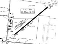
| A110-1 | ULTRALIGHTS & PWRD PRCHTS ON & INVOF ARPT. |
| A110-2 | FOR CD CTC COLUMBUS APCH AT 614-338-8537. |
| A110-5 | 8 FT CROPS ALG ENTR LEN RWY 04/22, 10 FT FM RWY EDGE, BOTH SIDES. |
| A110-6 | MOWED PATH FM RWY 04 END TO HNGR AREA NOT SUITABLE FOR ACFT. |
| A110-8 | TWY FM MIDFIELD TO HNGR AREA, 35 FT CLNC BTN 8 FT CROPS. |
| A15 | ARPT PHYS ADS: 1334 LUTHERAN CHURCH RD, DAYTON, OH 45417-7415. |
| A16 | CELL. |
| A33-04/22 | NMRS CRACKS IN PAVEMENT WITH 3 FT VEGETATION. |
| A35-04/22 | 5000 LBS PER AMGR. |
| A58-04 | +8 FT CROPS, 0-200 FT DIST, 45 FT R. |
| A58-22 | +10-20 FT BRUSH/TREES, 25 FT DIST, 20-125 FT L; +10-25 FT BRUSH/TREES, 0 FT DIST, 20-125 FT R; 8 FT CROPS, 15 FT DIST. |
| A83 | LDI TET OTS/UNREL. |
Runways
Runway Summary
| Runways: | 04/22 |
| Longest Runway: | 04/22 is 2900 ft (884 m) long |
| Runways with an Instrument Approach: |
I44 Airport Runway Details
| Runway 04/22 | 2900 ft x 52 ft (884 m x 16 m) | |
| Surface: | Asphalt - Poor condition - No special surface treatment | |
Runway 04 |
Runway 22 |
|
Elevation: |
925.0 | 925.0 |
Latitude: |
39-45-43.8800N | 39-46-04.8800N |
Longitude: |
084-20-47.2600W | 084-20-22.0600W |
|
Runway True Alignment: |
043 | 223 |
Glide Path Angle: |
0.0 degrees | 0.0 degrees |
Traffic Pattern: |
Left | Left |
Runway Markings Type: |
None | None |
Object at End: |
CROPS | TREES |
Object Height: |
8 | 40 |
Distance from End: |
201 | 201 |
Object Centerline Offset: |
125 ft. left and right of centerline | 90 ft. left of centerline |
REIL: |
No | No |
Touchdown Lights: |
No | No |
Centerline Lights: |
No | No |
Services
Airframe Repair: |
Minor |
Powerplant Repair: |
Minor |
Bottled Oxygen: |
None |
Bulk Oxygen: |
None |
Fuel Available: |
100LL, Jet A |
Landing Fees: |
No |
Parking: |
Hangars and tiedowns available |
Maps & Diagrams
I44 Sectional
Flight Planning
at skyvector.com
at skyvector.com