Location
Latitude: |
28-03-46.5130N (28.06292) |
Longitude: |
081-45-11.9320W (-81.753314) |
Elevation: |
145.5 feet MSL (44 m MSL) |
Magnetic Variation: |
6.5 W (as of April 2024 from WMM2020 model) |
Time Zone: |
UTC -5.0 (Standard Time) UTC -4.0 (Daylight Savings Time) |
From City: |
03 N.M. NW of Winter Haven, Florida |
Found On: |
Jacksonville Chart |
FAA Region: |
ASO |
Contacts
Manager: |
Publicly owned: |
| MICHAEL MOON 2073 HWY 92 WEST WINTER HAVEN, FL 33881 863-298-4551 |
CITY OF WINTER HAVEN P.O. BOX 2277 WINTER HAVEN, FL 33883-2277 863-291-5600 |
Operations
Airport Status: |
Operational |
Facility Use: |
Public |
Type: |
Airport |
Activation Date: |
04/1940 |
Control tower: |
No |
Attendance (Months/Days/Hours): |
Months/Days/Hours ALL/ALL/0700-1900 |
Boundary ARTCC: |
ZMA (Miami) |
Responsible ARTCC: |
ZMA (Miami) |
Lighting Schedule: |
SEE RMK |
Segmented Circle Indicator: |
Yes |
Traffic Pattern Altitude (MSL): |
1146 feet (349 m) |
NOTAMs Facility: |
GIF |
NOTAM-D Service: |
Yes |
International Airport of Entry: |
No |
Customs Landing Rights: |
No |
Military Landing Rights: |
Yes |
Civil/Military Joint Use: |
No |
Based Aircraft
| Single Engine: | 152 |
| Multi Engine: | 15 |
| Jet Engine: | 1 |
| GA Helicopters: | 3 |
| Gliders: | 1 |
Annual Operations (as of 07/24/2018)
| Total Operations: | 77998 | |
| GA Local: | 46798 | 60.0% |
| GA Itinerant: | 31200 | 40.0% |
Communications
| CTAF: | 123.050 |
| Unicom: | 123.050 |
| Approach: | TAMPA 119.9 119.9 119.9 |
| Departure: | TAMPA 119.9 119.9 119.9 |
| ASOS: | 133.675 (863-956-2097) |
Fixed Based Operators (FBOs) & Fuel
(Click on a business for detail)
Please help us keep this information up to date. This is a FREE SERVICE just like everything else on Airport Guide! If you see that a business needs to be added, modified, or deleted please fill out our Update Form.
To add, modify, or delete a business click here.
Please help us keep this information up to date. This is a FREE SERVICE just like everything else on Airport Guide! If you see that a business needs to be added, modified, or deleted please fill out our Update Form.
Area Code: 863 |
| Business Name | Frequency | Phone | Fuel Grade |
|---|---|---|---|
| Jack Brown Seaplane Base
Update FBO info |
956-2243, 967-5891 | 100LL | |
| Winter Haven Air Services, Inc.
Update FBO info |
Unicom 122.7 | 293-2501 | 100LL, Jet A, Mogas |
Flight Service Stations
| Primary | Alternate | |
| FSS on Field: | N | |
| FSS Name (ID): | Saint Petersburg(PIE) | |
| Frequency: | ||
| Toll Free Phone: | 1-800-WX-BRIEF |
Instrument Procedures / Charts
FAA Terminal Procedures valid from 0901Z 03/21/24 to 0901Z 04/18/24.
There are various types of charts available for an airport. They are listed in the Page Type column. Here is a legend for those types:
APD - Airport Diagram
DP - Departure Procedure Charts
HOT - Hot Spots
IAP - Instrument Approach Procedure Charts
MIN - Minimums
STAR - Standard Terminal Arrival Charts
| Page Type | Page Name | Volume | Action Since Last Cycle |
|---|---|---|---|
| APD | AIRPORT DIAGRAM | SE-3 | |
| IAP | RNAV (GPS) RWY 05 | SE-3 | |
| IAP | RNAV (GPS) RWY 11 | SE-3 | |
| IAP | VOR-A | SE-3 | |
| MIN | ALTERNATE MINIMUMS | SE-3 | |
| MIN | TAKEOFF MINIMUMS | SE-3 |
Terminal Procedures are only available for airports in several countries with more being added all the time. If you are looking for a specific country's charts, please send an email to support(at)airportguide.com stating the country name. This will be used to prioritize the implementation.
Navigation Aids (Navaids) near GIF
| Dist (NM) | ID | Morse Code | Name | Type | Freq | True Hdg | Mag Hdg |
|---|---|---|---|---|---|---|---|
| 14.5 | LAL | . _ . . . _ . _ . . | Lakeland | VORTAC | 116.00 | 251 | 257 |
| 23.5 | RHZ | . _ . . . . . _ _ . . | Zephyrhills | NDB | 253 | 294 | 300 |
| 31.5 | OR | _ _ _ . _ . | Herny | NDB | 221 | 32 | 39 |
| 36.3 | ORL | _ _ _ . _ . . _ . . | Orlando | VORTAC | 112.20 | 37 | 44 |
| 40.9 | TP | _ . _ _ . | Cosme | NDB | 368 | 272 | 278 |
| 41.6 | TPA | _ . _ _ . . _ | Tampa Intl | VOT | 111.00 | 262 | 268 |
| 42.1 | MCF | _ _ _ . _ . . . _ . | Macdill | TACAN | 111.00 | 253 | 259 |
| 43.7 | AM | . _ _ _ | Picny | NDB | 388 | 254 | 260 |
| 45.4 | LEE | . _ . . . . | Leesburg | NDB | 335 | 356 | 363 |
| 50.2 | PIE | . _ _ . . . . | St Petersburg | VORTAC | 116.40 | 259 | 265 |
| 50.5 | PI | . _ _ . . . | Capok | NDB | 360 | 265 | 271 |
| 51.0 | SFB | . . . . . _ . _ . . . | Sanford | NDB | 408 | 31 | 38 |
| 55.8 | SQT | . . . _ _ . _ _ | Satellite | NDB | 257 | 87 | 94 |
| 57.4 | TVV | _ . . . _ . . . _ | Space Center Executive | NDB | 237 | 61 | 68 |
| 58.3 | SRQ | . . . . _ . _ _ . _ | Sarasota | VOR-DME | 117.00 | 227 | 233 |
| 59.2 | MLB | _ _ . _ . . _ . . . | Melbourne | VOR-DME | 115.85 | 87 | 94 |
| 61.3 | COF | _ . _ . _ _ _ . . _ . | Patrick | TACAN | 115.00 | 79 | 86 |
| 65.4 | DED | _ . . . _ . . | Deland/Dcmsnd | NDB | 201 | 22 | 29 |
| 69.9 | PGD | . _ _ . _ _ . _ . . | Punta Gorda | VOR | 110.20 | 190 | 196 |
| 70.1 | VNC | . . . _ _ . _ . _ . | Venice | NDB | 206 | 211 | 217 |
Nearby Airports with Fuel
Notices to Airmen (NOTAMS)
Remarks
| A11 | CONTACT PERSON: T. MICHAEL STAVRES |
| A110-1 | BROWN'S SPB LOCATED ON ADJACENT LAKE. |
| A110-10 | NMRS ACFT OPERG WO RDOS INVOF ARPT AND SPB. |
| A110-2 | ANEMOMETER REMOTED TO FBO OFFICE. |
| A110-3 | GLIDER ACFT OPERG ON AND INVOF ARPT. |
| A110-7 | GCO AVBL ON FREQ 121.725 THRU TAMPA CD. |
| A110-8 | RWY 05 PREFERRED FOR CALM OR LIGHT WINDS |
| A110-9 | FOR CD IF UNA VIA GCO CTC TAMPA APCH AT 813-878-2528. |
| A57-05 | RWY 05 APCH SLOPE 16:1 TO AER DUE TO 33 FT TREES 515 FT FM RWY END AND 150 FT LEFT . |
| A57-11 | RWY 29 APCH SLOPE 23:1 TO AER. |
| A81-APT | ACTVT REIL RWY 11 & 29; PAPI RWY 05 & 23; MIRL RWY 05/23 & 11/29 - CTAF. |
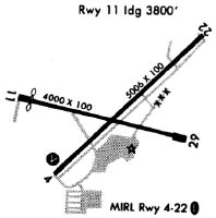
Runways
Runway Summary
| Runways: | 05/23 11/29 |
| Longest Runway: | 05/23 is 5005 ft (1526 m) long |
| Runways with an Instrument Approach: |
GIF Airport Runway Details
| Runway 05/23 | 5005 ft x 100 ft (1526 m x 30 m) | |
| Runway Length Source: | 3RD PARTY SURVEY as of 06/26/2020 | |
| Surface: | Asphalt - Fair condition - No special surface treatment | |
| Runway Pavement Class: | 35 /F/B/X/T | |
| Runway Edge Lights: | Medium Intensity | |
Runway Weight Bearing Capacity (in thousands of pounds) |
||
| Single Wheel Landing Gear: | 89.0 | |
| Dual Wheel Landing Gear: | 142.0 | |
Runway 05 |
Runway 23 |
|
Elevation: |
141.6 | 141.2 |
Latitude: |
28-03-30.6888N | 28-04-05.7318N |
Longitude: |
081-45-28.3504W | 081-44-48.8424W |
|
Runway True Alignment: |
045 | 225 |
Glide Path Angle: |
3.0 degrees | 3.0 degrees |
Traffic Pattern: |
Left | Left |
Runway Markings Type: |
Nonprecision Instrument | Nonprecision Instrument |
Runway Markings Condition: |
Fair | Fair |
Object at End: |
FENCE | TREES |
Object Height: |
5 | 41 |
Distance from End: |
205 | 1245 |
Object Centerline Offset: |
250 ft. left of centerline | 65 ft. left of centerline |
Visual Glide Slope Indicators: |
2-Light PAPI On Left Side Of Runway | 2-Light PAPI On Left Side Of Runway |
REIL: |
Yes | Yes |
Threshold Crossing Height: |
45 | 44 |
| Runway 11/29 | 4001 ft x 60 ft (1220 m x 18 m) | |
| Runway Length Source: | 3RD PARTY SURVEY as of 06/26/2020 | |
| Surface: | Asphalt - Fair condition - No special surface treatment | |
| Runway Pavement Class: | 37 /F/B/X/T | |
| Runway Edge Lights: | Medium Intensity | |
Runway Weight Bearing Capacity (in thousands of pounds) |
||
| Single Wheel Landing Gear: | 94.0 | |
| Dual Wheel Landing Gear: | 151.0 | |
Runway 11 |
Runway 29 |
|
Elevation: |
143.0 | 141.1 |
Latitude: |
28-03-48.8975N | 28-03-39.8810N |
Longitude: |
081-45-37.8467W | 081-44-54.3643W |
|
Runway True Alignment: |
103 | 283 |
Glide Path Angle: |
0.0 degrees | 0.0 degrees |
Traffic Pattern: |
Left | Left |
Runway Markings Type: |
Nonprecision Instrument | Basic |
Runway Markings Condition: |
Fair | Fair |
Object at End: |
PLINE | FENCE |
Object Height: |
43 | 5 |
Object Marked/Lighted?: |
Lighted | |
Distance from End: |
1430 | 215 |
Object Centerline Offset: |
250 ft. left of centerline | 65 ft. left of centerline |
REIL: |
Yes | Yes |
Services
Airframe Repair: |
Minor |
Powerplant Repair: |
Minor |
Bottled Oxygen: |
None |
Bulk Oxygen: |
None |
Fuel Available: |
100LL |
Landing Fees: |
No |
Parking: |
Hangars and tiedowns available |
Maps & Diagrams
GIF Sectional
Flight Planning
at skyvector.com
at skyvector.com