Location
Latitude: |
36-11-44.6000N (36.195722) |
Longitude: |
082-48-40.9000W (-82.811361) |
Elevation: |
1607.5 feet MSL (490 m MSL) |
Magnetic Variation: |
6.8 W (as of April 2024 from WMM2020 model) |
Time Zone: |
UTC -5.0 (Standard Time) UTC -4.0 (Daylight Savings Time) |
From City: |
02 N.M. N of Greeneville, Tennessee |
Found On: |
Cincinnati Chart |
FAA Region: |
ASO |
Contacts
Manager: |
Publicly owned: |
| ANGELA ALLEY 246 AIRPORT ROAD GREENEVILLE, TN 37745 423-823-9310 |
GREENEVILLE MUNI AIRPORT AUTHORITY 200 N COLLEGE ST GREENEVILLE, TN 37743 423-639-7105 |
Operations
Airport Status: |
Operational |
Facility Use: |
Public |
Type: |
Airport |
Control tower: |
No |
Attendance (Months/Days/Hours): |
Months/Days/Hours ALL/MON-FRI/0730-1730 |
Boundary ARTCC: |
ZTL (Atlanta) |
Responsible ARTCC: |
ZTL (Atlanta) |
Segmented Circle Indicator: |
No |
Traffic Pattern Altitude (MSL): |
2608 feet (795 m) |
NOTAMs Facility: |
BNA |
NOTAM-D Service: |
Yes |
International Airport of Entry: |
No |
Customs Landing Rights: |
No |
Military Landing Rights: |
Yes |
Civil/Military Joint Use: |
No |
Based Aircraft
| Single Engine: | 70 |
| Multi Engine: | 6 |
| GA Helicopters: | 1 |
Annual Operations (as of 08/31/2019)
| Total Operations: | 37730 | |
| Air Taxi: | 7000 | 18.6% |
| GA Local: | 16500 | 43.7% |
| GA Itinerant: | 13700 | 36.3% |
| Military Aircraft: | 530 | 1.4% |
Communications
| CTAF: | 122.700 |
| Unicom: | 122.700 |
| Approach: | TRI CITY 128.05 128.05 ATLANTA ARTCC |
| Departure: | TRI CITY 128.05 128.05 ATLANTA ARTCC |
| AWOS-3: | 128.425 (423-639-5081) |
- APCH/DEP SVC PRVDD BY ATLANTA ARTCC ON FREQS 127.85/269.3 (GLADE SPRINGS RCAG) WHEN TRI CITY APCH CTL CLSD.
Fixed Based Operators (FBOs) & Fuel
(Click on a business for detail)
Please help us keep this information up to date. This is a FREE SERVICE just like everything else on Airport Guide! If you see that a business needs to be added, modified, or deleted please fill out our Update Form.
To add, modify, or delete a business click here.
Please help us keep this information up to date. This is a FREE SERVICE just like everything else on Airport Guide! If you see that a business needs to be added, modified, or deleted please fill out our Update Form.
| Business Name | Frequency | Phone | Fuel Grade |
|---|---|---|---|
| Greeneville Municipal Airport
Website Update FBO info |
Unicom 122.7 | 423-823-9310 | 100LL |
Flight Service Stations
| Primary | Alternate | |
| FSS on Field: | N | |
| FSS Name (ID): | Nashville(BNA) | |
| Frequency: | ||
| Toll Free Phone: | 1-800-WX-BRIEF |
Instrument Procedures / Charts
FAA Terminal Procedures valid from 0901Z 03/21/24 to 0901Z 04/18/24.
There are various types of charts available for an airport. They are listed in the Page Type column. Here is a legend for those types:
APD - Airport Diagram
DP - Departure Procedure Charts
HOT - Hot Spots
IAP - Instrument Approach Procedure Charts
MIN - Minimums
STAR - Standard Terminal Arrival Charts
| Page Type | Page Name | Volume | Action Since Last Cycle |
|---|---|---|---|
| IAP | RNAV (GPS) RWY 05 | SE-1 | |
| MIN | ALTERNATE MINIMUMS | SE-1 | |
| MIN | TAKEOFF MINIMUMS | SE-1 |
Terminal Procedures are only available for airports in several countries with more being added all the time. If you are looking for a specific country's charts, please send an email to support(at)airportguide.com stating the country name. This will be used to prioritize the implementation.
Navigation Aids (Navaids) near GCY
| Dist (NM) | ID | Morse Code | Name | Type | Freq | True Hdg | Mag Hdg |
|---|---|---|---|---|---|---|---|
| 5.3 | DYQ | _ . . _ . _ _ _ _ . _ | Dulaney | NDB | 263 | 226 | 233 |
| 16.0 | RVN | . _ . . . . _ _ . | Rogersville | NDB | 329 | 347 | 354 |
| 19.5 | BO | _ . . . _ _ _ | Booie | NDB | 221 | 51 | 58 |
| 27.0 | SOT | . . . _ _ _ _ | Snowbird | VORTAC | 108.80 | 205 | 212 |
| 27.1 | EZT | . _ _ . . _ | Elizabethton | NDB | 275 | 74 | 81 |
| 32.2 | TR | _ . _ . | Mocca | NDB | 299 | 47 | 54 |
| 32.6 | JXT | . _ _ _ _ . . _ _ | Jefferson | NDB | 346 | 261 | 268 |
| 36.0 | HMV | . . . . _ _ . . . _ | Holston Mountain | VORTAC | 114.60 | 66 | 73 |
| 41.2 | IM | . . _ _ | Keans | NDB | 357 | 164 | 171 |
| 45.2 | BAR | _ . . . . _ . _ . | Hemlock | NDB | 320 | 92 | 99 |
| 51.7 | GZG | _ _ . _ _ . . _ _ . | Glade Spring | VOR-DME | 110.20 | 42 | 49 |
| 52.7 | VJ | . . . _ . _ _ _ | Whine | NDB | 236 | 51 | 58 |
| 54.2 | SUG | . . . . . _ _ _ . | Sugarloaf Mountain | VORTAC | 112.20 | 150 | 157 |
| 55.4 | VXV | . . . _ _ . . _ . . . _ | Volunteer | VORTAC | 116.40 | 251 | 257 |
| 57.8 | BRA | _ . . . . _ . . _ | Broad River | NDB | 379 | 163 | 170 |
| 61.8 | TYS | _ _ . _ _ . . . | Knoxville | VOT | 112.00 | 248 | 254 |
| 62.4 | MRN | _ _ . _ . _ . | Lenoir | FAN MARKER | 112 | 119 | |
| 62.6 | FIQ | . . _ . . . _ _ . _ | Fiddlers | NDB | 391 | 117 | 124 |
| 73.4 | JUH | . _ _ _ . . _ . . . . | Ashee | NDB | 410 | 78 | 85 |
| 74.2 | HKY | . . . . _ . _ _ . _ _ | Hickory Regional | VOT | 110.00 | 111 | 118 |
Nearby Airports with Fuel
Notices to Airmen (NOTAMS)
Remarks
| A110-2 | PAEW ADJ RWY & TWY. |
| A110-3 | FOR CD CTC ATLANTA ARTCC AT 770-210-7692. |
| A17 | UNATNDD CHRISTMAS & JULY 4TH; AFT HR - 423-329-2580. |
| A30A-23 | CALM WIND RWY. |
Runways
Runway Summary
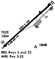
| Runways: | 05/23 |
| Longest Runway: | 05/23 is 6300 ft (1920 m) long |
| Runways with an Instrument Approach: |
GCY Airport Runway Details
| Runway 05/23 | 6300 ft x 100 ft (1920 m x 30 m) | |
| Runway Length Source: | 3RD PARTY SURVEY as of 02/03/2017 | |
| Surface: | Asphalt - Excellent condition - No special surface treatment | |
| Runway Pavement Class: | 43 /F/C/X/T | |
| Runway Edge Lights: | Medium Intensity | |
Runway Weight Bearing Capacity (in thousands of pounds) |
||
| Single Wheel Landing Gear: | 22.0 | |
| Dual Wheel Landing Gear: | 35.0 | |
Runway 05 |
Runway 23 |
|
Elevation: |
1599.0 | 1602.4 |
Latitude: |
36-11-23.5512N | 36-12-05.7365N |
Longitude: |
082-49-09.1962W | 082-48-12.6427W |
|
Runway True Alignment: |
047 | 227 |
Glide Path Angle: |
3.0 degrees | 4.0 degrees |
Traffic Pattern: |
Left | Right |
Runway Markings Type: |
Nonprecision Instrument | Nonprecision Instrument |
Runway Markings Condition: |
Good | Good |
Object at End: |
TREE | |
Object Height: |
189 | |
Distance from End: |
3731 | |
Object Centerline Offset: |
290 ft. left of centerline | |
Visual Glide Slope Indicators: |
2-Light PAPI On Left Side Of Runway | 2-Light PAPI On Left Side Of Runway |
REIL: |
Yes | Yes |
Threshold Crossing Height: |
40 | 42 |
Services
Airframe Repair: |
Major |
Powerplant Repair: |
Major |
Bottled Oxygen: |
None |
Bulk Oxygen: |
None |
Fuel Available: |
100LL, Jet A-1+ |
Landing Fees: |
No |
Parking: |
Tiedowns available |
Maps & Diagrams
GCY Sectional
Flight Planning
at skyvector.com
at skyvector.com