Location
Latitude: |
30-54-54.9000N (30.91525) |
Longitude: |
102-54-46.0000W (-102.912778) |
Elevation: |
3011.0 feet MSL (918 m MSL) |
Magnetic Variation: |
5.9 E (as of April 2024 from WMM2020 model) |
Time Zone: |
UTC -6.0 (Standard Time) UTC -5.0 (Daylight Savings Time) |
From City: |
02 N.M. NW of Fort Stockton, Texas |
Found On: |
San Antonio Chart |
FAA Region: |
ASW |
Contacts
Manager: |
Publicly owned: |
| TOM CHAPMAN PO BOX 1624 FORT STOCKTON, TX 79735 432-336-6261 |
PECOS COUNTY PECOS COUNTY COURTHOUSE, 103 W CALLAGHAN FORT STOCKTON, TX 79735 432-336-2792 |
Operations
Airport Status: |
Operational |
Facility Use: |
Public |
Type: |
Airport |
Activation Date: |
01/1947 |
Control tower: |
No |
Attendance (Months/Days/Hours): |
Months/Days/Hours ALL/ALL/0800-1700 |
Boundary ARTCC: |
ZAB (Albuquerque) |
Responsible ARTCC: |
ZAB (Albuquerque) |
Lighting Schedule: |
SEE RMK |
Segmented Circle Indicator: |
Yes |
Traffic Pattern Altitude (MSL): |
4011 feet (1223 m) |
NOTAMs Facility: |
FST |
NOTAM-D Service: |
Yes |
International Airport of Entry: |
No |
Customs Landing Rights: |
No |
Military Landing Rights: |
Yes |
Civil/Military Joint Use: |
No |
Based Aircraft
| Single Engine: | 15 |
| Multi Engine: | 1 |
| GA Helicopters: | 1 |
| Gliders: | 2 |
Annual Operations (as of 05/16/2021)
| Total Operations: | 4520 | |
| GA Local: | 3000 | 66.4% |
| GA Itinerant: | 1500 | 33.2% |
| Military Aircraft: | 20 | 0.4% |
Communications
| CTAF: | 122.800 |
| Unicom: | 122.800 |
| ASOS: | 118.525 (432-336-7591) |
- APCH/DEP SVC PRVDD BY ALBUQUERQUE ARTCC (ABQ) ON FREQS 135.875/292.15 (FORT STOCKTON RCAG).
Fixed Based Operators (FBOs) & Fuel
(Click on a business for detail)
Please help us keep this information up to date. This is a FREE SERVICE just like everything else on Airport Guide! If you see that a business needs to be added, modified, or deleted please fill out our Update Form.
To add, modify, or delete a business click here.
Please help us keep this information up to date. This is a FREE SERVICE just like everything else on Airport Guide! If you see that a business needs to be added, modified, or deleted please fill out our Update Form.
Area Code: 915 |
| Business Name | Frequency | Phone | Fuel Grade |
|---|---|---|---|
| Hargus Aviation
Update FBO info |
Unicom 122.8 | 336-3151 | 100LL, Jet A |
Flight Service Stations
| Primary | Alternate | |
| FSS on Field: | N | |
| FSS Name (ID): | San Angelo(SJT) | |
| Frequency: | ||
| Toll Free Phone: | 1-800-WX-BRIEF |
Instrument Procedures / Charts
FAA Terminal Procedures valid from 0901Z 03/21/24 to 0901Z 04/18/24.
There are various types of charts available for an airport. They are listed in the Page Type column. Here is a legend for those types:
APD - Airport Diagram
DP - Departure Procedure Charts
HOT - Hot Spots
IAP - Instrument Approach Procedure Charts
MIN - Minimums
STAR - Standard Terminal Arrival Charts
| Page Type | Page Name | Volume | Action Since Last Cycle |
|---|---|---|---|
| IAP | RNAV (GPS) RWY 12 | SC-3 | |
| IAP | RNAV (GPS) RWY 30 | SC-3 | |
| IAP | VOR RWY 12 | SC-3 | |
| MIN | ALTERNATE MINIMUMS | SC-3 | |
| MIN | TAKEOFF MINIMUMS | SC-3 |
Terminal Procedures are only available for airports in several countries with more being added all the time. If you are looking for a specific country's charts, please send an email to support(at)airportguide.com stating the country name. This will be used to prioritize the implementation.
Navigation Aids (Navaids) near FST
| Dist (NM) | ID | Morse Code | Name | Type | Freq | True Hdg | Mag Hdg |
|---|---|---|---|---|---|---|---|
| 3.9 | FST | . . _ . . . . _ | Fort Stockton | VORTAC | 116.90 | 304 | 298 |
| 42.5 | IMP | . . _ _ . _ _ . | Marathon | NDB | 388 | 203 | 197 |
| 46.8 | BWR | _ . . . . _ _ . _ . | Brewster County | NDB | 412 | 234 | 228 |
| 47.5 | PEQ | . _ _ . . _ _ . _ | Pecos | VOR-DME | 116.50 | 314 | 308 |
| 60.0 | INK | . . _ . _ . _ | Wink | VORTAC | 112.10 | 343 | 337 |
| 65.3 | MRF | _ _ . _ . . . _ . | Marfa | VOR-DME | 115.90 | 235 | 229 |
| 66.8 | XAA | _ . . _ . _ . _ | Kent | NDB | 225 | 275 | 269 |
| 71.0 | MA | _ _ . _ | Farly | NDB | 326 | 24 | 18 |
| 71.5 | MAF | _ _ . _ . . _ . | Midland | VOT | 108.20 | 30 | 24 |
| 75.3 | MAF | _ _ . _ . . _ . | Midland | VORTAC | 114.80 | 29 | 23 |
| 96.8 | VHN | . . . _ . . . . _ . | Van Horn | NDB | 233 | 275 | 269 |
Nearby Airports with Fuel
| Dist (NM) | Name (Airport IDs) | True Hdg | Mag Hdg | Fuel Grade |
|---|---|---|---|---|
| 40.0 | Roy Hurd Meml Airport (MIF E01) |
0 | 354 | 100LL, Jet A |
| 41.6 | Pecos Municipal Airport (PEQ KPEQ PEQ) |
312 | 306 | 100LL, Jet A-1+ |
| 51.0 | Alpine-Casparis Municipal Airport (ALE E38) |
231 | 225 | 100LL, Jet A, Jet A-1+ |
| 53.9 | Winkler County Airport (INK KINK INK) |
344 | 338 | 100LL, Jet A+ |
| 63.4 | Terrell County Airport (6R6) |
145 | 140 | 100LL |
| 65.7 | Marfa Municipal Airport (MRF KMRF MRF) |
240 | 234 | 100LL, Jet A |
| 66.1 | Odessa-Schlemeyer Field Airport (KODO ODO) |
23 | 17 | 100LL, Jet A |
| 70.9 | Skywest Inc Airport (7T7) |
37 | 32 | 100LL, MOGAS |
| 71.6 | Midland International Air And Space Port Airport (MAF KMAF MAF) |
30 | 24 | 100LL, Jet A, Jet A-1 |
| 79.1 | Midland Airpark Airport (MDD KMDD MDD) |
31 | 25 | 100LL, Jet A |
| 87.2 | Andrews County Airport (E11) |
12 | 6 | 100LL, Jet A |
| 88.8 | Ozona Municipal Airport (OZA KOZA OZA) |
96 | 91 | 100LL, Jet A |
| 96.6 | Culberson County Airport (VHN KVHN VHN) |
275 | 268 | 100LL, Jet A-1+ |
Notices to Airmen (NOTAMS)
Remarks
| A110-3 | 3210 FT TOWER 2 MILES NE. |
| A110-4 | FOR CD IF UNA TO CTC ON FSS FREQ, CTC ALBUQUERQUE ARTCC AT 505-856-4561. |
| A110-5 | TURF RWY 7/25, 11/29,16/34 ROUGH. RWY ENDS 16 & 25 NOT INSPECTED DUE TO FLD CONDS. |
| A14 | COUNTY COMMISSIONER. |
| A33-07/25 | RWY NOT MNTND; HAS TALL WEEDS, GRASS AND THORNS. |
| A33-11/29 | RWY NOT MNTND; HAS TALL WEEDS, GRASS AND THORNS. |
| A33-16/34 | RWY NOT MNTND; HAS TALL WEEDS, GRASS AND THORNS. |
| A42-11 | THR NOT MKD. |
| A42-29 | THR NOT MKD. |
| A43-12 | UNUSBL BYD 8 DEG RIGHT OF RCL. |
| A43-30 | UNUSBL BYD 8 DEG RIGHT OF RCL. |
| A52-16 | 10 FT TREES AND BRUSH AT THR ACRS APCH. |
| A58-12 | 5 FT FENCE, 0-199 FT DSTC, 145 FT L. |
| A58-30 | GRAVEL ROAD AT 190 FT ACRS APCH. |
| A70-FUEL-10 | 0LL FOR FUEL & SVCS AFT HRS CALL 432-336-9900 OR UNICOM. 24 HR SELF SERVE AVBL WITH MAJOR CREDIT CARD. |
| A81-APT | MIRL RWY 03/21 & 12/30 PRESET LOW INTST; TO INCR INTST ACTVT - CTAF. PAPI RWY 12 & 30 OPR CONSLY. |
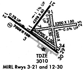
Runways
Runway Summary
| Runways: | 03/21 07/25 11/29 12/30 16/34 |
| Longest Runway: | 12/30 is 7508 ft (2288 m) long |
| Runways with an Instrument Approach: |
FST Airport Runway Details
| Runway 03/21 | 4400 ft x 60 ft (1341 m x 18 m) | |
| Runway Length Source: | NGS as of 03/12/2008 | |
| Surface: | Asphalt - Fair condition - No special surface treatment | |
| Runway Edge Lights: | Medium Intensity | |
Runway 03 |
Runway 21 |
|
Elevation: |
3006.7 | 2956.7 |
Latitude: |
30-54-49.2316N | 30-55-24.2093N |
Longitude: |
102-55-06.8303W | 102-54-36.7644W |
|
Runway True Alignment: |
037 | 217 |
Glide Path Angle: |
0.0 degrees | 0.0 degrees |
Runway Markings Type: |
Basic | Basic |
Runway Markings Condition: |
Fair | Fair |
Object at End: |
PLINE | |
Object Height: |
110 | |
Distance from End: |
3100 | |
Object Centerline Offset: |
0 ft. left and right of centerline |
| Runway 07/25 | 4961 ft x 150 ft (1512 m x 46 m) | |
| Runway Length Source: | 3RD PARTY SURVEY as of 05/01/2007 | |
| Surface: | Asphalt - Fair condition - No special surface treatment | |
Runway 07 |
Runway 25 |
|
Elevation: |
2994.1 | 2965.6 |
Latitude: |
30-54-55.0050N | 30-55-02.0693N |
Longitude: |
102-54-58.4987W | 102-54-02.1492W |
|
Runway True Alignment: |
082 | 262 |
Glide Path Angle: |
0.0 degrees | 0.0 degrees |
Traffic Pattern: |
Left | Left |
Runway Markings Type: |
None | None |
Runway Markings Condition: |
Fair | Fair |
Object at End: |
TREES | |
Object Height: |
9 | |
Distance from End: |
186 | |
Object Centerline Offset: |
0 ft. left and right of centerline |
| Runway 11/29 | 3348 ft x 100 ft (1020 m x 30 m) | |
| Runway Length Source: | 3RD PARTY SURVEY as of 05/01/2007 | |
| Surface: | Asphalt - Fair condition - No special surface treatment | |
Runway 11 |
Runway 29 |
|
Elevation: |
2995.5 | 3005.4 |
Latitude: |
30-54-53.5057N | 30-54-33.9012N |
Longitude: |
102-54-58.7757W | 102-54-27.7941W |
|
Runway True Alignment: |
126 | 306 |
Glide Path Angle: |
0.0 degrees | 0.0 degrees |
Traffic Pattern: |
Left | Left |
Runway Markings Type: |
None | None |
Runway Markings Condition: |
Poor | Poor |
Object at End: |
ROAD | |
Object Height: |
10 | |
Distance from End: |
65 | |
Object Centerline Offset: |
0 ft. left and right of centerline |
| Runway 12/30 | 7508 ft x 100 ft (2288 m x 30 m) | |
| Runway Length Source: | NGS as of 03/12/2008 | |
| Surface: | Asphalt - Fair condition - No special surface treatment | |
| Runway Edge Lights: | Medium Intensity | |
Runway Weight Bearing Capacity (in thousands of pounds) |
||
| Single Wheel Landing Gear: | 24.0 | |
Runway 12 |
Runway 30 |
|
Elevation: |
2985.2 | 3010.4 |
Latitude: |
30-55-12.4151N | 30-54-28.2116N |
Longitude: |
102-55-36.3986W | 102-54-27.1442W |
|
Runway True Alignment: |
127 | 307 |
Glide Path Angle: |
3.0 degrees | 3.0 degrees |
Traffic Pattern: |
Left | Left |
Runway Markings Type: |
Nonprecision Instrument | Nonprecision Instrument |
Runway Markings Condition: |
Good | Good |
Object at End: |
TREE | ROAD |
Object Height: |
20 | 10 |
Distance from End: |
500 | 200 |
Object Centerline Offset: |
0 ft. left and right of centerline | |
Visual Glide Slope Indicators: |
4-Light PAPI On Left Side Of Runway | 4-Light PAPI On Left Side Of Runway |
Threshold Crossing Height: |
45 | 45 |
| Runway 16/34 | 3981 ft x 150 ft (1213 m x 46 m) | |
| Runway Length Source: | 3RD PARTY SURVEY as of 05/01/2007 | |
| Surface: | Asphalt - Fair condition - No special surface treatment | |
Runway 16 |
Runway 34 |
|
Elevation: |
2964.2 | 3003.7 |
Latitude: |
30-55-14.8526N | 30-54-35.8931N |
Longitude: |
102-54-35.4120W | 102-54-28.6105W |
|
Runway True Alignment: |
171 | 351 |
Glide Path Angle: |
0.0 degrees | 0.0 degrees |
Runway Markings Type: |
None | None |
Runway Markings Condition: |
Fair | Fair |
Object at End: |
BRUSH | TREE |
Object Height: |
10 | 58 |
Distance from End: |
0 | 1317 |
Object Centerline Offset: |
0 ft. left and right of centerline |
Services
Bottled Oxygen: |
None |
Bulk Oxygen: |
None |
Fuel Available: |
100LL, Jet A-1+ |
Landing Fees: |
No |
Parking: |
Tiedowns available |
Maps & Diagrams
FST Sectional
Flight Planning
at skyvector.com
at skyvector.com