Location
Latitude: |
43-59-28.1000N (43.991139) |
Longitude: |
070-56-52.4000W (-70.947889) |
Elevation: |
454.6 feet MSL (139 m MSL) |
Magnetic Variation: |
14.5 W (as of April 2024 from WMM2020 model) |
Time Zone: |
UTC -5.0 (Standard Time) UTC -4.0 (Daylight Savings Time) |
From City: |
03 N.M. SE of Fryeburg, Maine |
Found On: |
New York Chart |
FAA Region: |
ANE |
Contacts
Manager: |
Publicly owned: |
| DAVID CULLINAN EASTERN SLOPE AIRPORT FRYEBURG, ME 04037 207-890-7636 |
EASTERN SLOPE REGIONAL APT AUTH BOX 334 FRYEBURG, ME 04037 207-935-4711 |
Operations
Airport Status: |
Operational |
Facility Use: |
Public |
Type: |
Airport |
Activation Date: |
10/1961 |
Control tower: |
No |
Attendance (Months/Days/Hours): |
Months/Days/Hours ALL/ALL/0800-1700 |
Boundary ARTCC: |
ZBW (Boston) |
Responsible ARTCC: |
ZBW (Boston) |
Lighting Schedule: |
SEE RMK |
Segmented Circle Indicator: |
Yes |
Traffic Pattern Altitude (MSL): |
1455 feet (443 m) |
NOTAMs Facility: |
IZG |
NOTAM-D Service: |
Yes |
International Airport of Entry: |
No |
Customs Landing Rights: |
No |
Military Landing Rights: |
Yes |
Civil/Military Joint Use: |
No |
Based Aircraft
| Single Engine: | 35 |
| Multi Engine: | 2 |
| Jet Engine: | 1 |
Annual Operations (as of 08/16/2021)
| Total Operations: | 7850 | |
| Air Taxi: | 200 | 2.5% |
| GA Local: | 4000 | 51.0% |
| GA Itinerant: | 3500 | 44.6% |
| Military Aircraft: | 150 | 1.9% |
Communications
| CTAF: | 122.800 |
| Unicom: | 122.800 |
| Approach: | PORTLAND 119.75 119.75 BOSTON ARTCC |
| Departure: | PORTLAND 119.75 119.75 BOSTON ARTCC |
| ASOS: | 135.775 (207-935-2882) |
- APCH/DEP SVC PRVDD BY BOSTON ARTCC ON FREQ 128.2/263.05 (WATERBORO RCAG) WHEN PORTLAND ATCT CLSD.
Fixed Based Operators (FBOs) & Fuel
(Click on a business for detail)
Please help us keep this information up to date. This is a FREE SERVICE just like everything else on Airport Guide! If you see that a business needs to be added, modified, or deleted please fill out our Update Form.
To add, modify, or delete a business click here.
Please help us keep this information up to date. This is a FREE SERVICE just like everything else on Airport Guide! If you see that a business needs to be added, modified, or deleted please fill out our Update Form.
Area Code: 207 |
| Business Name | Frequency | Phone | Fuel Grade |
|---|
Flight Service Stations
| Primary | Alternate | |
| FSS on Field: | N | |
| FSS Name (ID): | Bangor(BGR) | |
| Frequency: | ||
| Toll Free Phone: | 1-800-WX-BRIEF |
Instrument Procedures / Charts
FAA Terminal Procedures valid from 0901Z 03/21/24 to 0901Z 04/18/24.
There are various types of charts available for an airport. They are listed in the Page Type column. Here is a legend for those types:
APD - Airport Diagram
DP - Departure Procedure Charts
HOT - Hot Spots
IAP - Instrument Approach Procedure Charts
MIN - Minimums
STAR - Standard Terminal Arrival Charts
| Page Type | Page Name | Volume | Action Since Last Cycle |
|---|---|---|---|
| IAP | RNAV (GPS) RWY 32 | NE-1 | |
| MIN | ALTERNATE MINIMUMS | NE-1 | |
| MIN | TAKEOFF MINIMUMS | NE-1 |
Terminal Procedures are only available for airports in several countries with more being added all the time. If you are looking for a specific country's charts, please send an email to support(at)airportguide.com stating the country name. This will be used to prioritize the implementation.
Navigation Aids (Navaids) near FRY
| Dist (NM) | ID | Morse Code | Name | Type | Freq | True Hdg | Mag Hdg |
|---|---|---|---|---|---|---|---|
| 8.9 | SZO | . . . _ _ . . _ _ _ | Sebago | NDB | 227 | 126 | 141 |
| 26.4 | LE | . _ . . . | Lewie | NDB | 240 | 93 | 108 |
| 33.2 | LCI | . _ . . _ . _ . . . | Laconia | FAN MARKER | 220 | 234 | |
| 34.6 | PWM | . _ _ . . _ _ _ _ | Portland | VOT | 111.00 | 126 | 141 |
| 34.8 | HIE | . . . . . . . | Witey | FAN MARKER | 310 | 324 | |
| 36.9 | ENE | . _ . . | Kennebunk | VOR-DME | 117.10 | 156 | 171 |
| 37.4 | LC | . _ . . _ . _ . | Blnap | NDB | 328 | 223 | 237 |
| 38.8 | GMA | _ _ . _ _ . _ | Mahn | NDB | 386 | 305 | 319 |
| 39.9 | BML | _ . . . _ _ . _ . . | Berlin | DME | 116.55 | 345 | 360 |
| 44.9 | NHZ | _ . . . . . _ _ . . | Brunswick | TACAN | 115.20 | 98 | 113 |
| 46.4 | PH | . _ _ . . . . . | Portland Lhb-P | MARINE NDB | 301 | 126 | 141 |
| 46.5 | ESG | . . . . _ _ . | Rollins | NDB | 260 | 173 | 187 |
| 53.1 | AU | . _ . . _ | Dunns | NDB | 366 | 61 | 76 |
| 53.3 | AUG | . _ . . _ _ _ . | Augusta | VOR-DME | 114.95 | 67 | 82 |
| 53.7 | CON | _ . _ . _ _ _ _ . | Concord | VOR-DME | 112.90 | 210 | 224 |
| 54.6 | PSM | . _ _ . . . . _ _ | Pease | DME | 116.5 | 174 | 188 |
| 55.7 | LLX | . _ . . . _ . . _ . . _ | Lyndonville | NDB | 353 | 303 | 317 |
| 56.0 | LAH | . _ . . . _ . . . . | Hanover | NDB | 276 | 252 | 266 |
| 56.8 | CO | _ . _ . _ _ _ | Epsom | NDB | 216 | 202 | 216 |
| 57.2 | RQM | . _ . _ _ . _ _ _ | Rangeley | NDB | 221 | 8 | 23 |
Nearby Airports with Fuel
Notices to Airmen (NOTAMS)
Remarks
| A110-1 | OBSTN: LGTD HILLS IN APCH TO RWY 14, 4500 FT N, 7000 FT SW, 10000 FT NW. |
| A110-3 | BIRDS & DEER ON & INVOF ARPT. |
| A110-4 | FOR CD CTC PORTLAND APCH AT 207-874-7320, WHEN APCH CLSD CTC BOSTON ARTCC AT 603-879-6859. |
| A110-5 | COLD TEMPERATURE AIRPORT. ALTITUDE CORRECTION REQUIRED AT OR BELOW -29C. |
| A16 | AMGR CELL: 207-890-7636. |
| A43-32 | VASI UNUSBL BYD 7 DEGS L & R OF CNTRLN. |
| A70-FUEL-10 | 0LL 24 HR CREDIT CARD FUEL: FOR 100LL, CALL-OUT FEE; FOR JET A AFT HRS: 207-935-4711 -FBO. |
| A75 | HNGR AVBLY: CALL: 207-935-4711. |
| A81-APT | ACTVT MIRL RWY 14/32 - CTAF. |
Runways
Runway Summary
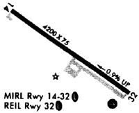
| Runways: | 14/32 |
| Longest Runway: | 14/32 is 4200 ft (1280 m) long |
| Runways with an Instrument Approach: |
FRY Airport Runway Details
| Runway 14/32 | 4200 ft x 75 ft (1280 m x 23 m) | |
| Runway Length Source: | 3RD PARTY SURVEY as of 07/25/2010 | |
| Surface: | Asphalt - Good condition - No special surface treatment | |
| Runway Edge Lights: | Medium Intensity | |
Runway Weight Bearing Capacity (in thousands of pounds) |
||
| Single Wheel Landing Gear: | 30.0 | |
Runway 14 |
Runway 32 |
|
Elevation: |
454.5 | 420.2 |
Latitude: |
43-59-40.4174N | 43-59-15.7728N |
Longitude: |
070-57-15.4545W | 070-56-29.2534W |
|
Runway True Alignment: |
126 | 306 |
Glide Path Angle: |
0.0 degrees | 3.0 degrees |
Traffic Pattern: |
Left | Left |
Runway Markings Type: |
Basic | Nonprecision Instrument |
Runway Markings Condition: |
Fair | Fair |
Object at End: |
TREES | |
Object Height: |
55 | |
Distance from End: |
2015 | |
Object Centerline Offset: |
200 ft. left of centerline | |
Visual Glide Slope Indicators: |
2-Box VASI On Left Side Of Runway | |
REIL: |
Yes | |
Threshold Crossing Height: |
17 |
Services
Airframe Repair: |
Major |
Powerplant Repair: |
Minor |
Bottled Oxygen: |
None |
Bulk Oxygen: |
None |
Fuel Available: |
100LL, MOGAS |
Landing Fees: |
No |
Parking: |
Hangars and tiedowns available |
Maps & Diagrams
FRY Sectional
Flight Planning
at skyvector.com
at skyvector.com