Location
Latitude: |
35-08-25.1370N (35.140316) |
Longitude: |
111-40-09.2690W (-111.669241) |
Elevation: |
7014.7 feet MSL (2138 m MSL) |
Magnetic Variation: |
9.9 E (as of April 2024 from WMM2020 model) |
Time Zone: |
UTC -7.0 (Standard Time) UTC -7.0 (Daylight Savings Time) |
From City: |
04 N.M. S of Flagstaff, Arizona |
Found On: |
Phoenix Chart |
FAA Region: |
AWP |
Contacts
Manager: |
Publicly owned: |
| BRIAN GALL 6200 S. PULLIAM DR, 204 FLAGSTAFF, AZ 86005 928-213-2934 |
CITY OF FLAGSTAFF 211 W ASPEN AVE FLAGSTAFF, AZ 86001 928-213-2930 |
Operations
Airport Status: |
Operational |
Facility Use: |
Public |
Type: |
Airport |
Activation Date: |
11/1948 |
Control tower: |
Yes |
Attendance (Months/Days/Hours): |
Months/Days/Hours ALL/ALL/ALL |
Boundary ARTCC: |
ZAB (Albuquerque) |
Responsible ARTCC: |
ZAB (Albuquerque) |
Lighting Schedule: |
SEE RMK |
Segmented Circle Indicator: |
No |
Traffic Pattern Altitude (MSL): |
8015 feet (2443 m) |
NOTAMs Facility: |
FLG |
NOTAM-D Service: |
Yes |
International Airport of Entry: |
No |
Customs Landing Rights: |
No |
Military Landing Rights: |
Yes |
Civil/Military Joint Use: |
No |
Aircraft Rescue and Firefighting: |
Class I ARFF Index: B Air Carrier Service: Scheduled Certification Date: 05/1973 |
Based Aircraft
| Single Engine: | 99 |
| Multi Engine: | 5 |
| Jet Engine: | 1 |
| GA Helicopters: | 4 |
| Gliders: | 3 |
Annual Operations (as of 08/31/2022)
| Total Operations: | 39851 | |
| Commercial: | 3434 | 8.6% |
| Air Taxi: | 8521 | 21.4% |
| GA Local: | 8527 | 21.4% |
| GA Itinerant: | 18446 | 46.3% |
| Military Aircraft: | 923 | 2.3% |
Communications
| CTAF: | 134.550 |
| Unicom: | 122.950 |
| Tower: | FLAGSTAFF 134.55 239.25 Hrs: 0600-2100 (1 APR-30 SEP); 0700-1900 (1 OCT-31 MAR) |
| Ground: | 121.9 |
| Approach: | PHOENIX 126.375 126.375 |
| Departure: | PHOENIX 126.375 126.375 |
| ATIS: | 125.8 Hrs: 24 |
| ASOS: | 125.8 (928-779-2439) |
| EMERG: | 121.5 |
- ATCT OWNED BY FAA; LEASED TO CITY AND OPERATED UNDER CONTRACT TO BARTON ATC INC.
- COMMUNICATIONS PRVDD BY PRESCOTT RADIO ON FREQ 122.3 (COTTONWOOD RCO).
Fixed Based Operators (FBOs) & Fuel
(Click on a business for detail)
Please help us keep this information up to date. This is a FREE SERVICE just like everything else on Airport Guide! If you see that a business needs to be added, modified, or deleted please fill out our Update Form.
To add, modify, or delete a business click here.
Please help us keep this information up to date. This is a FREE SERVICE just like everything else on Airport Guide! If you see that a business needs to be added, modified, or deleted please fill out our Update Form.
Area Code: 520 |
| Business Name | Frequency | Phone | Fuel Grade |
|---|---|---|---|
| Guardian Air
Update FBO info |
774-9121, 773-2146 | ||
| Wiseman Aviation
Update FBO info |
Unicom 122.95 | 877-947-3326, 779-9585 | 100LL, Jet A |
Flight Service Stations
| Primary | Alternate | |
| FSS on Field: | N | |
| FSS Name (ID): | Prescott(PRC) | |
| Frequency: | ||
| Toll Free Phone: | 1-800-WX-BRIEF |
Instrument Procedures / Charts
FAA Terminal Procedures valid from 0901Z 03/21/24 to 0901Z 04/18/24.
There are various types of charts available for an airport. They are listed in the Page Type column. Here is a legend for those types:
APD - Airport Diagram
DP - Departure Procedure Charts
HOT - Hot Spots
IAP - Instrument Approach Procedure Charts
MIN - Minimums
STAR - Standard Terminal Arrival Charts
| Page Type | Page Name | Volume | Action Since Last Cycle |
|---|---|---|---|
| APD | AIRPORT DIAGRAM | SW-4 | |
| DP | FLAGSTAFF ONE | SW-4 | |
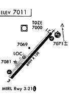
| IAP | ILS OR LOC RWY 21 | SW-4 | |
| IAP | RNAV (GPS) RWY 03 | SW-4 | |
| IAP | RNAV (GPS) RWY 21 | SW-4 | |
| IAP | VOR RWY 21 | SW-4 | |
| MIN | ALTERNATE MINIMUMS | SW-4 | |
| MIN | TAKEOFF MINIMUMS | SW-4 |
Terminal Procedures are only available for airports in several countries with more being added all the time. If you are looking for a specific country's charts, please send an email to support(at)airportguide.com stating the country name. This will be used to prioritize the implementation.
Navigation Aids (Navaids) near FLG
| Dist (NM) | ID | Morse Code | Name | Type | Freq | True Hdg | Mag Hdg |
|---|---|---|---|---|---|---|---|
| 0.5 | FLG | . . _ . . _ . . _ _ . | Flagstaff | VOR-DME | 113.85 | 329 | 319 |
| 43.2 | INW | . . _ . . _ _ | Winslow | VORTAC | 112.60 | 96 | 86 |
| 47.2 | PRC | . _ _ . . _ . _ . _ . | Prescott | VOT | 110.00 | 231 | 221 |
| 47.8 | DRK | _ . . . _ . _ . _ | Drake | VORTAC | 114.10 | 236 | 226 |
| 54.4 | GCN | _ _ . _ . _ . _ . | Grand Canyon | VOR-DME | 111.65 | 334 | 324 |
| 55.7 | PAN | . _ _ . . _ _ . | Payson | DME | 116.35 | 162 | 152 |
| 62.0 | TBC | _ _ . . . _ . _ . | Tuba City | VORTAC | 113.50 | 18 | 8 |
| 96.2 | PGS | . _ _ . _ _ . . . . | Peach Springs | VOR-DME | 112.00 | 288 | 278 |
| 97.2 | SOW | . . . _ _ _ . _ _ | Show Low | NDB | 206 | 122 | 112 |
Nearby Airports with Fuel
| Dist (NM) | Name (Airport IDs) | True Hdg | Mag Hdg | Fuel Grade |
|---|---|---|---|---|
| 18.5 | Sedona Airport (SDX KSEZ SEZ) |
198 | 188 | 100LL, Jet A |
| 27.6 | H A Clark Meml Field Airport (KCMR CMR) |
291 | 281 | 100LL, Jet A-1+ |
| 38.5 | Valle Airport (VLE 40G) |
322 | 312 | 100LL, Jet A |
| 47.0 | Prescott Regional - Ernest A Love Field Airport (PRC KPRC PRC) |
231 | 221 | 100LL, Jet A |
| 47.0 | Winslow-Lindbergh Regional Airport (INW KINW INW) |
98 | 88 | 100LL, Jet A |
| 54.0 | Grand Canyon Ntl Park Airport (GCN KGCN GCN) |
334 | 324 | 100LL, Jet A |
| 55.5 | Payson Airport (PJB KPAN PAN) |
162 | 152 | 100LL, Jet A+ |
| 76.1 | Holbrook Municipal Airport (P14) |
98 | 89 | 100LL |
| 87.0 | Taylor Airport (TYZ KTYL TYL) |
117 | 108 | 100LL |
| 89.5 | Phoenix Deer Valley Airport (DVT KDVT DVT) |
193 | 183 | 100LL, Jet A+ |
| 89.6 | Wickenburg Municipal Airport (E25) |
218 | 208 | 100LL, Jet A-1+ |
| 91.8 | Scottsdale Airport (SCF KSDL SDL) |
187 | 177 | 100LL, Jet A-1+ |
| 97.4 | Show Low Regional Airport (SOW KSOW SOW) |
122 | 113 | 100LL, Jet A |
Notices to Airmen (NOTAMS)
Remarks
| A110-1 | SNOW REMOVAL EQUIP MAY BE ON RWY; MNT 134.55 WHEN ATCT CLSD. ARPT MAY BE CLSD DURG SNOW REMOVAL OPS. |
| A110-13 | ILS UNMON WHEN ATCT CLSD. |
| A110-14 | FOR CD WHEN ATCT CLSD, CTC PHOENIX APCH AT 602-306-2565. |
| A110-15 | FUEL AVBL H24. |
| A110-2 | NOISE ABATEMENT PROC IN EFT; AVOID FLT OVR VILLAGE 3 MI S. |
| A16 | EXT 10 |
| A30-03/21 | RWY 21 CALM WIND RWY. EXP WS & TURB WHEN SFC WINDS EXCEED 10 KT. |
| A81-APT | WHEN ATCT CLSD ACTVT MALSR RWY 21; HIRL RWY 03/21 - CTAF. PAPI RWY 3/21 ON CONSLY. |
| E147 | TPA: CONVENTIONAL ACFT 989 FT AGL, HELICOPTER 489 FT AGL, HIGH PERFORMANCE 1489 FT AGL. |
Runways
Runway Summary
| Runways: | 03/21 |
| Longest Runway: | 03/21 is 8800 ft (2682 m) long |
| Runways with an Instrument Approach: | 21 |
FLG Airport Runway Details
| Runway 03/21 | 8800 ft x 150 ft (2682 m x 46 m) | |
| Runway Length Source: | OWNER as of 08/30/2016 | |
| Surface: | Asphalt - Excellent condition - Saw-cut or plastic grooved | |
| Runway Pavement Class: | 37 /F/D/W/T | |
| Runway Edge Lights: | High Intensity | |
Runway Weight Bearing Capacity (in thousands of pounds) |
||
| Single Wheel Landing Gear: | 30.0 | |
| Dual Wheel Landing Gear: | 95.0 | |
| Dual Tandem Wheel Landing Gear: | 140.0 | |
Runway 03 |
Runway 21 |
|
Elevation: |
7014.4 | 6996.4 |
Latitude: |
35-07-52.3859N | 35-08-57.8856N |
Longitude: |
111-40-44.1283W | 111-39-34.4013W |
|
Runway True Alignment: |
041 | 221 |
ILS Type: |
LOC/GS | |
Glide Path Angle: |
3.0 degrees | 3.0 degrees |
Traffic Pattern: |
Left | |
Runway Markings Type: |
Nonprecision Instrument | Precision Instrument |
Runway Markings Condition: |
Good | Good |
Visual Glide Slope Indicators: |
4-Light PAPI On Left Side Of Runway | 4-Light PAPI On Left Side Of Runway |
Approach Light System: |
1,400 Foot Medium Intensity Approach Lighting System With Runway Alignment Indicator Lights | |
REIL: |
No | No |
Touchdown Lights: |
No | No |
Centerline Lights: |
No | No |
Threshold Crossing Height: |
52 | 51 |
Threshold Elevation: |
6998.3 | |
Displaced Threshold: |
1800 | |
Threshold Latitude: |
35-08-44.4883N | |
Threshold Longitude: |
111-39-48.6669W | |
Declared Distances |
||
Take Off Run Avbl. (TORA): |
8800 | 8800 |
Take Off Distance Avbl. (TODA): |
8800 | 8800 |
Actual Stop Dist. Avbl. (ASDA): |
8800 | 8800 |
Landing Dist. Avbl. (LDA): |
8800 | 7000 |
Services
Airframe Repair: |
Minor |
Powerplant Repair: |
Minor |
Bottled Oxygen: |
None |
Bulk Oxygen: |
None |
Fuel Available: |
100LL, Jet A |
Landing Fees: |
No |
Parking: |
Tiedowns available |
Maps & Diagrams
FLG Sectional
Flight Planning
at skyvector.com
at skyvector.com