Location
Latitude: |
64-46-41.1000N (64.778083) |
Longitude: |
141-08-58.6000W (-141.149611) |
Elevation: |
907.2 feet MSL (277 m MSL) |
Magnetic Variation: |
17.8 E (as of April 2024 from WMM2020 model) |
Time Zone: |
UTC -9.0 (Standard Time) UTC -8.0 (Daylight Savings Time) |
From City: |
02 N.M. E of Eagle, Alaska |
Found On: |
Dawson Chart |
FAA Region: |
AAL |
Contacts
Manager: |
Publicly owned: |
| SAM JENNINGS P O BOX 356 TOK, AK 99780 907-883-5128 |
ALASKA DOT&PF NORTHERN REGION 2301 PEGER RD FAIRBANKS, AK 99709 907-451-2200 |
Operations
Airport Status: |
Operational |
Facility Use: |
Public |
Type: |
Airport |
Activation Date: |
11/1949 |
Control tower: |
No |
Attendance (Months/Days/Hours): |
Months/Days/Hours Unattended |
Boundary ARTCC: |
ZAN (Anchorage) |
Responsible ARTCC: |
ZAN (Anchorage) |
Lighting Schedule: |
SEE RMK |
Segmented Circle Indicator: |
Yes |
Traffic Pattern Altitude (MSL): |
1907 feet (581 m) |
NOTAMs Facility: |
EAA |
NOTAM-D Service: |
Yes |
International Airport of Entry: |
No |
Customs Landing Rights: |
No |
Military Landing Rights: |
Yes |
Civil/Military Joint Use: |
No |
Based Aircraft
| Single Engine: | 1 |
Annual Operations (as of 12/31/2021)
| Total Operations: | 2400 | |
| Air Taxi: | 400 | 16.7% |
| GA Local: | 800 | 33.3% |
| GA Itinerant: | 1200 | 50.0% |
Communications
| CTAF: | 122.800 |
| Unicom: | 122.800 |
| ASOS: | 135.55 (907-547-2351) |
- COMMUNICATIONS PRVDD BY NORTHWAY FSS ON FREQ 122.3 (EAGLE RCO).
- APCH/DEP SVC PRVDD BY ANCHORAGE ARTCC (ZAN) ON FREQS 135.3/322.5 (BIG DELTA RCAG).
Fixed Based Operators (FBOs) & Fuel
(Click on a business for detail)
Please help us keep this information up to date. This is a FREE SERVICE just like everything else on Airport Guide! If you see that a business needs to be added, modified, or deleted please fill out our Update Form.
To add, modify, or delete a business click here.
Please help us keep this information up to date. This is a FREE SERVICE just like everything else on Airport Guide! If you see that a business needs to be added, modified, or deleted please fill out our Update Form.
Area Code: 907 |
| Business Name | Frequency | Phone | Fuel Grade |
|---|
Flight Service Stations
| Primary | Alternate | |
| FSS on Field: | N | |
| FSS Name (ID): | Northway(ORT) | Fairbanks (FAI) |
| Frequency: | ||
| Toll Free Phone: | 1-800-478-6611 | 1-866-248-6516 |
Instrument Procedures / Charts
FAA Terminal Procedures valid from 0901Z 03/21/24 to 0901Z 04/18/24.
There are various types of charts available for an airport. They are listed in the Page Type column. Here is a legend for those types:
APD - Airport Diagram
DP - Departure Procedure Charts
HOT - Hot Spots
IAP - Instrument Approach Procedure Charts
MIN - Minimums
STAR - Standard Terminal Arrival Charts
| Page Type | Page Name | Volume | Action Since Last Cycle |
|---|---|---|---|
| IAP | RNAV (GPS)-A | AK-1 | Changed |
| MIN | ALTERNATE MINIMUMS | AK-1 | |
| MIN | TAKEOFF MINIMUMS | AK-1 |
Terminal Procedures are only available for airports in several countries with more being added all the time. If you are looking for a specific country's charts, please send an email to support(at)airportguide.com stating the country name. This will be used to prioritize the implementation.
Navigation Aids (Navaids) near EAA
| Dist (NM) | ID | Morse Code | Name | Type | Freq | True Hdg | Mag Hdg |
|---|---|---|---|---|---|---|---|
| 68.3 | DA | Dawson City | NDB | 214 | 130 | 112 |
Nearby Airports with Fuel
| Dist (NM) | Name (Airport IDs) | True Hdg | Mag Hdg | Fuel Grade |
|---|---|---|---|---|
| 99.0 | Tok Junction Airport (TKJ PFTO 6K8) |
209 | 192 | 100LL, Jet A |
Notices to Airmen (NOTAMS)
Remarks
| A110-1 | RY CONDITION NOT MONITORED; RECOMMEND VISUAL INSPECTION PRIOR TO LANDING. |
| A110-2 | SUAIS - 125.3/126.3(1-800-758-8723). |
| A110-3 | WX CAMERA AVBL ON INTERNET AT HTTPS://WEATHERCAMS.FAA.GOV |
| A110-5 | HEL OPN FR SOUTH RAMP DURG SUMMER MONTHS. |
| A110-6 | 100LL AND JET A FUEL AVBL BY CALLING 907-547-2220. |
| A110-7 | COLD TEMPERATURE AIRPORT. ALTITUDE CORRECTION REQUIRED AT OR BELOW -13C. |
| A42-07 | RYS 07 & 25 MKD WITH REFLECTIVE THLD PANELS & CONES. |
| A81-APT | ACTVT MIRL RY 07/25 & VASI RY 07 - CTAF. |
| A81-BCN | ACTVT ROTG BCN - CTAF. |
| E80 | CUSTOMS UNAVBL CONTACT 907-774-2252 FOR INFO. |
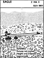
Runways
Runway Summary
| Runways: | 07/25 |
| Longest Runway: | 07/25 is 3600 ft (1097 m) long |
| Runways with an Instrument Approach: |
EAA Airport Runway Details
| Runway 07/25 | 3600 ft x 75 ft (1097 m x 23 m) | |
| Runway Length Source: | 3RD PARTY SURVEY as of 07/14/2013 | |
| Surface: | Gravel - Good condition - No special surface treatment | |
| Runway Edge Lights: | Medium Intensity | |
Runway 07 |
Runway 25 |
|
Elevation: |
900.7 | 907.2 |
Latitude: |
64-46-41.9004N | 64-46-40.3766N |
Longitude: |
141-09-40.0702W | 141-08-17.0969W |
|
Runway True Alignment: |
092 | 272 |
Glide Path Angle: |
3.8 degrees | 0.0 degrees |
Traffic Pattern: |
Left | |
Object at End: |
HILL | TREES |
Object Height: |
4 | 90 |
Distance from End: |
0 | 1239 |
Object Centerline Offset: |
110 ft. right of centerline | 218 ft. left of centerline |
Visual Glide Slope Indicators: |
4-Box VASI On Left Side Of Runway | |
Threshold Crossing Height: |
39 |
Services
Fuel Available: |
100LL, Jet A |
Parking: |
Tiedowns available |
Maps & Diagrams
EAA Sectional
Flight Planning
at skyvector.com
at skyvector.com