Location
Latitude: |
37-38-54.9540N (37.648598) |
Longitude: |
097-15-02.1580W (-97.250599) |
Elevation: |
1378.0 feet MSL (420 m MSL) |
Magnetic Variation: |
3 E (as of April 2024 from WMM2020 model) |
Time Zone: |
UTC -6.0 (Standard Time) UTC -5.0 (Daylight Savings Time) |
From City: |
04 N.M. SE of Wichita, Kansas |
Found On: |
Wichita Chart |
FAA Region: |
ACE |
Contacts
Manager: |
Privately owned: |
| TODD BAYLESS 10511 EAST CENTRAL WICHITA, KS 67201 (316) 515-8365 |
CESSNA AIRCRAFT COMPANY 10511 EAST CENTRAL WICHITA, KS 67277 (316) 515-6000 |
Operations
Airport Status: |
Operational |
Facility Use: |
Public |
Type: |
Airport |
Activation Date: |
04/1940 |
Control tower: |
No |
Attendance (Months/Days/Hours): |
Months/Days/Hours Unattended |
Boundary ARTCC: |
ZKC (Kansas City) |
Responsible ARTCC: |
ZKC (Kansas City) |
Segmented Circle Indicator: |
Yes |
Traffic Pattern Altitude (MSL): |
2378 feet (725 m) |
NOTAMs Facility: |
ICT |
NOTAM-D Service: |
Yes |
Based Aircraft
| Single Engine: | 15 |
| Multi Engine: | 1 |
Annual Operations (as of 07/19/2019)
| Total Operations: | 100 | |
| GA Itinerant: | 100 | 100.0% |
Communications
| CTAF: | 122.900 |
| Clearance Del.: | 125.0 125.0 125.0 |
| Approach: | WICHITA |
| Departure: | WICHITA |
Fixed Based Operators (FBOs) & Fuel
(Click on a business for detail)
Please help us keep this information up to date. This is a FREE SERVICE just like everything else on Airport Guide! If you see that a business needs to be added, modified, or deleted please fill out our Update Form.
To add, modify, or delete a business click here.
Please help us keep this information up to date. This is a FREE SERVICE just like everything else on Airport Guide! If you see that a business needs to be added, modified, or deleted please fill out our Update Form.
Area Code: 316 |
| Business Name | Frequency | Phone | Fuel Grade |
|---|
Flight Service Stations
| Primary | Alternate | |
| FSS on Field: | N | |
| FSS Name (ID): | Wichita(ICT) | |
| Frequency: | ||
| Toll Free Phone: | 1-800-WX-BRIEF |
Instrument Procedures / Charts
FAA Terminal Procedures valid from 0901Z 03/21/24 to 0901Z 04/18/24.
There are various types of charts available for an airport. They are listed in the Page Type column. Here is a legend for those types:
APD - Airport Diagram
DP - Departure Procedure Charts
HOT - Hot Spots
IAP - Instrument Approach Procedure Charts
MIN - Minimums
STAR - Standard Terminal Arrival Charts
| Page Type | Page Name | Volume | Action Since Last Cycle |
|---|---|---|---|
| IAP | RNAV (GPS)-D | NC-2 | |
| IAP | VOR-C | NC-2 |
Terminal Procedures are only available for airports in several countries with more being added all the time. If you are looking for a specific country's charts, please send an email to support(at)airportguide.com stating the country name. This will be used to prioritize the implementation.
Navigation Aids (Navaids) near CEA
| Dist (NM) | ID | Morse Code | Name | Type | Freq | True Hdg | Mag Hdg |
|---|---|---|---|---|---|---|---|
| 1.8 | IAB | . . . _ _ . . . | Mc Connell | TACAN | 116.50 | 207 | 204 |
| 8.7 | ICT | . . _ . _ . _ | Wichita | VOT | 114.00 | 265 | 262 |
| 10.6 | IC | . . _ . _ . | Piche | NDB | 332 | 246 | 243 |
| 16.8 | ICT | . . _ . _ . _ | Wichita | VORTAC | 113.80 | 290 | 287 |
| 20.6 | EGT | . _ _ . _ | Wellington | NDB | 414 | 198 | 195 |
| 25.0 | EWK | . . _ _ _ . _ | Newton | NDB | 281 | 357 | 354 |
| 29.8 | CA | _ . _ . . _ | Harvs | NDB | 395 | 357 | 354 |
| 35.1 | SO | . . . _ _ _ | Sawcy | NDB | 353 | 162 | 159 |
| 38.6 | HUT | . . . . . . _ _ | Hutchinson | VOR-DME | 116.80 | 303 | 300 |
| 42.9 | HU | . . . . . . _ | Saltt | NDB | 404 | 311 | 308 |
| 46.8 | MPR | _ _ . _ _ . . _ . | Mc Pherson | NDB | 227 | 333 | 330 |
| 49.9 | PN | . _ _ . _ . | Ponca | NDB | 515 | 171 | 168 |
| 52.8 | ANY | . _ _ . _ . _ _ | Anthony | TACAN | 112.90 | 236 | 233 |
| 54.3 | PER | . _ _ . . . _ . | Pioneer | VORTAC | 113.20 | 175 | 172 |
| 62.3 | LYO | . _ . . _ . _ _ _ _ _ | Lyons | NDB | 386 | 312 | 309 |
| 64.7 | SL | . . . . _ . . | Flory | NDB | 344 | 343 | 340 |
| 65.2 | EMP | . _ _ . _ _ . | Emporia | VORTAC | 112.80 | 53 | 50 |
| 66.0 | HRU | . . . . . _ . . . _ | Herington | NDB | 407 | 18 | 15 |
| 71.2 | PTT | . _ _ . _ _ | Pratt | NDB | 356 | 274 | 271 |
| 76.4 | BV | _ . . . . . . _ | Dewie | NDB | 201 | 129 | 126 |
Nearby Airports with Fuel
Notices to Airmen (NOTAMS)
Remarks
| A110*G | THIS AIRPORT HAS BEEN SURVEYED BY THE NATIONAL GEODETIC SURVEY. |
| A110-2 | ACFT OPNS SHOULD COORDINATE WITH MC CONNELL AFB PRIOR TO ARRIVAL AND DEP - CONTROL TOWER 127.25. |
| A110-3 | RWY 17R/35L USED ONLY BY CESSNA PERSONNEL; CLOSED TO PUBLIC. |
| A110-4 | FOR CD CTC WICHITA APCH AT 316-350-1520. |
| A57-17 | APCH RATIO 40:1 TO DSPLCD THLD. |
| A57-35 | APCH RATIO 27:1 TO DSPLCD THLD. |
| A58-35 | 8 FT FENCE 170 FT FM RY END. |
| E111 | EXISTED PRIOR TO 1959. |
Runways
Runway Summary
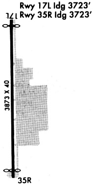
| Runways: | 17/35 |
| Longest Runway: | 17/35 is 3873 ft (1180 m) long |
| Runways with an Instrument Approach: |
CEA Airport Runway Details
| Runway 17/35 | 3873 ft x 40 ft (1180 m x 12 m) | |
| Surface: | Asphalt - Good condition - No special surface treatment | |
Runway 17 |
Runway 35 |
|
Elevation: |
1373.0 | 1373.0 |
Latitude: |
37-39-14.0690N | 37-38-35.7790N |
Longitude: |
097-15-02.1120W | 097-15-02.1450W |
|
Runway True Alignment: |
180 | 000 |
Glide Path Angle: |
0.0 degrees | 0.0 degrees |
Traffic Pattern: |
Left | Right |
Runway Markings Type: |
Basic | Basic |
Runway Markings Condition: |
Good | Good |
Object at End: |
ROAD | ROAD |
Object Height: |
10 | 13 |
Distance from End: |
252 | 210 |
Object Centerline Offset: |
0 ft. left and right of centerline | 0 ft. left and right of centerline |
Threshold Elevation: |
1372.3 | 1372.0 |
Displaced Threshold: |
150 | 150 |
Threshold Latitude: |
37-39-12.5900N | 37-38-37.2600N |
Threshold Longitude: |
097-15-02.1200W | 097-15-02.1500W |
Services
Airframe Repair: |
Major |
Powerplant Repair: |
Major |
Bottled Oxygen: |
Low Pressure |
Bulk Oxygen: |
None |
Fuel Available: |
100LL, Jet A |
Landing Fees: |
No |
Parking: |
Hangars and tiedowns available |
Maps & Diagrams
CEA Sectional
Flight Planning
at skyvector.com
at skyvector.com