Location
Latitude: |
40-52-30.8090N (40.875225) |
Longitude: |
074-16-52.8610W (-74.28135) |
Elevation: |
172.3 feet MSL (53 m MSL) |
Magnetic Variation: |
12.5 W (as of April 2024 from WMM2020 model) |
Time Zone: |
UTC -5.0 (Standard Time) UTC -4.0 (Daylight Savings Time) |
From City: |
02 N.M. N of Caldwell, New Jersey |
Found On: |
New York Chart |
FAA Region: |
AEA |
Contacts
Manager: |
Publicly owned: |
| JOE CALI 27 WRIGHT WAY FAIRFIELD, NJ 07004 973-227-4567 |
ESSEX COUNTY IMPROVEMENT AUTHORITY 27 WRIGHT WAY FAIRFIELD, NJ 07004 973-575-0952 |
Operations
Airport Status: |
Operational |
Facility Use: |
Public |
Type: |
Airport |
Activation Date: |
02/1938 |
Control tower: |
Yes |
Attendance (Months/Days/Hours): |
Months/Days/Hours ALL/ALL/0700-2300 |
Boundary ARTCC: |
ZNY (New York) |
Responsible ARTCC: |
ZNY (New York) |
Lighting Schedule: |
SEE RMK |
Segmented Circle Indicator: |
No |
Traffic Pattern Altitude (MSL): |
1172 feet (357 m) |
NOTAMs Facility: |
CDW |
NOTAM-D Service: |
Yes |
International Airport of Entry: |
No |
Customs Landing Rights: |
No |
Military Landing Rights: |
Yes |
Civil/Military Joint Use: |
No |
Based Aircraft
| Single Engine: | 183 |
| Multi Engine: | 22 |
| Jet Engine: | 6 |
| GA Helicopters: | 10 |
Annual Operations (as of 10/31/2023)
| Total Operations: | 124889 | |
| Commercial: | 20 | 0.0% |
| Air Taxi: | 6978 | 5.6% |
| GA Local: | 50790 | 40.7% |
| GA Itinerant: | 65423 | 52.4% |
| Military Aircraft: | 1678 | 1.3% |
Communications
| CTAF: | 119.800 |
| Unicom: | 122.950 |
| Tower: | CALDWELL 119.8 Hrs: 0700-2300 |
| Clearance Del.: | 121.1 |
| Ground: | 121.9 |
| Approach: | NEW YORK |
| Departure: | NEW YORK |
| ATIS: | 135.5 Hrs: 24 |
| ASOS: | 135.5 (973-575-4417) |
- FREQ 121.5 NOT AVAILABLE.
Fixed Based Operators (FBOs) & Fuel
(Click on a business for detail)
Please help us keep this information up to date. This is a FREE SERVICE just like everything else on Airport Guide! If you see that a business needs to be added, modified, or deleted please fill out our Update Form.
To add, modify, or delete a business click here.
Please help us keep this information up to date. This is a FREE SERVICE just like everything else on Airport Guide! If you see that a business needs to be added, modified, or deleted please fill out our Update Form.
Area Code: 973 |
| Business Name | Frequency | Phone | Fuel Grade |
|---|---|---|---|
| C & W Aero Services, Inc.
Update FBO info |
227-5750 | ||
| Caldwell Air Service, Inc.
Update FBO info |
Unicom 123.3 | 808-9047 | 100LL, Jet A |
| Caldwell Flight Academy
Update FBO info |
227-1707 | 100LL, Jet A | |
| Essex County Airport
Update FBO info |
Unicom 122.95 | 227-4567, -4568, 575-0952 | |
| Helicopter Services & Instruction
Website Update FBO info |
(973) 575-8807 | ||
| Mac Dan Aviation Corp.
Update FBO info |
227-1180 | 100LL, Jet A | |
| Mustang Aviation
Update FBO info |
575-8807 | 100LL, Jet A | |
| Nazarian Aviation Corp.
Update FBO info |
575-1779 | 100LL |
Flight Service Stations
| Primary | Alternate | |
| FSS on Field: | N | |
| FSS Name (ID): | Millville(MIV) | |
| Frequency: | ||
| Toll Free Phone: | 1-800-WX-BRIEF |
Instrument Procedures / Charts
FAA Terminal Procedures valid from 0901Z 03/21/24 to 0901Z 04/18/24.
There are various types of charts available for an airport. They are listed in the Page Type column. Here is a legend for those types:
APD - Airport Diagram
DP - Departure Procedure Charts
HOT - Hot Spots
IAP - Instrument Approach Procedure Charts
MIN - Minimums
STAR - Standard Terminal Arrival Charts
| Page Type | Page Name | Volume | Action Since Last Cycle |
|---|---|---|---|
| APD | AIRPORT DIAGRAM | NE-2 | |
| HOT | HOT SPOT | NE-2 | |
| IAP | LOC RWY 22 | NE-2 | |
| IAP | RNAV (GPS) RWY 04 | NE-2 | |
| IAP | RNAV (GPS) RWY 10 | NE-2 | |
| IAP | RNAV (GPS) RWY 22 | NE-2 | |
| MIN | ALTERNATE MINIMUMS | NE-2 | |
| MIN | TAKEOFF MINIMUMS | NE-2 | |
| STAR | JAIKE FOUR (RNAV) | NE-2 | |
| STAR | JAIKE FOUR (RNAV)[DELIMITER] CONT.1 | NE-2 | |
| STAR | MAZIE THREE (RNAV) | NE-2 | |
| STAR | WILKES-BARRE FOUR | NE-2 |
Terminal Procedures are only available for airports in several countries with more being added all the time. If you are looking for a specific country's charts, please send an email to support(at)airportguide.com stating the country name. This will be used to prioritize the implementation.
Navigation Aids (Navaids) near CDW
| Dist (NM) | ID | Morse Code | Name | Type | Freq | True Hdg | Mag Hdg |
|---|---|---|---|---|---|---|---|
| 8.0 | TE | _ . | Torby | NDB | 214 | 122 | 135 |
| 10.1 | TEB | _ . _ . . . | Teterboro | VOR-DME | 108.40 | 99 | 112 |
| 10.5 | CAT | _ . _ . . _ _ | Chatham | NDB | 254 | 219 | 231 |
| 11.2 | EWR | . . _ _ . _ . | Maryann | FAN MARKER | 157 | 170 | |
| 12.9 | EWR | . . _ _ . _ . | Newark | DME | 113.75 | 158 | 171 |
| 16.4 | SAX | . . . . _ _ . . _ | Sparta | VORTAC | 115.70 | 314 | 326 |
| 19.5 | LGA | . _ . . _ _ . . _ | La Guardia | VOR-DME | 113.10 | 106 | 119 |
| 23.6 | CRI | _ . _ . . _ . . . | Canarsie | VOR-DME | 112.30 | 131 | 144 |
| 25.0 | BWZ | _ . . . . _ _ _ _ . . | Broadway | VOR-DME | 114.20 | 259 | 271 |
| 25.8 | OGY | _ _ _ _ _ . _ . _ _ | Bridge | NDB | 414 | 135 | 148 |
| 27.3 | SBJ | . . . _ . . . . _ _ _ | Solberg | VOR-DME | 112.90 | 230 | 242 |
| 27.4 | JFK | . _ _ _ . . _ . _ . _ | Kennedy | VOR-DME | 115.90 | 121 | 134 |
| 27.6 | STW | . . . _ . _ _ | Stillwater | VOR-DME | 109.60 | 285 | 297 |
| 34.3 | COL | _ . _ . _ _ _ . _ . . | Colts Neck | VOR-DME | 115.40 | 170 | 182 |
| 35.0 | HUO | . . . . . . _ _ _ _ | Huguenot | VOR-DME | 116.10 | 336 | 348 |
| 36.7 | SW | . . . . _ _ | Neely | NDB | 335 | 3 | 16 |
| 36.8 | FR | . . _ . . _ . | Frikk | NDB | 407 | 99 | 112 |
| 39.9 | CMK | _ . _ . _ _ _ . _ | Carmel | VOR-DME | 116.60 | 52 | 65 |
| 40.6 | SKU | . . . _ . _ . . _ | Stanwyck | FAN MARKER | 15 | 28 | |
| 40.6 | SKU | . . . _ . _ . . _ | Stanwyck | NDB | 261 | 15 | 28 |
Nearby Airports with Fuel
Notices to Airmen (NOTAMS)
Remarks
| A110-10 | DEER & BIRDS ON & INVOF ARPT. |
| A110-11 | NON-STANDARD TRAFFIC PATTERNS FOR RWY 04 PROHIBITED DUE TO NOISE SENSITIVE AREA SOUTHWEST OF THE AIRPORT. |
| A110-12 | FOR CD WHEN ATCT IS CLSD CTC NEW YORK APCH AT 800-645-3206 |
| A110-13 | ROTOCRAFT: IF PSBL, CROSS THE ARPT BDRY AT OR ABV 700 FT MSL. |
| A110-14 | ENG RUN-UPS ON TWY N AT AER 28 SHD BE CONDUCTED TO LMT EFCT TO ACFT PARKED ON RN RAMP. |
| A110-2 | LCL OPNS SUSPENDED FROM 2300-0700 MON THRU SAT 2300 SAT UNTIL 1000 SUN. |
| A110-3 | FIXED WING VFR ACFT DEP: RWY 4 - FLY RWY HDG FOR 1 MI, THEN TURN CROSSWIND IF REMAINING IN THE TFC PAT. IF DEPARTING THE TFC PAT, CONT ON RWY HDG TIL REACHING TFC PAT ALT. |
| A110-4 | FIXED WING VFR ACFT DEP: RWY 10 - FLY HDG 080 DEG AT RWY DEP END. UPON REACHING 900 FT MSL, TURN CROSSWIND IF REMAINING IN THE TFC PAT; IF DEPARTING THE TFC PAT, CONT ON HDG 080 DEG TIL REACHING TFC PAT ALT. |
| A110-5 | FIXED WING VFR ACFT DEP: RWY 22 - FLY RWY HDG TIL REACHING 900 FT MSL, THEN TURN CROSSWIND IF REMAINING IN THE TFC PAT. IF DEPARTING THE TFC PAT, CONT ON RWY HDG TIL REACHING TFC PAT ALT. |
| A110-6 | FIXED WING VFR ACFT DEP: RWY 28 - FLY RWY HDG FOR 1 MI THEN TURN CROSSWIND IF REMAINING IN THE TFC PAT. IF DEPARTING THE TFC PAT, CONT ON RWY HDG TIL READHING TFC PAT ALT. |
| A110-8 | PILOTS BE ALERT -- THE MORRISTOWN ILS & GPS RWY 23 APPROACHES TRANSIT ESSEX CO ARPT CLASS D ASP. TFC PASSES TWO MI WEST OF THE ARPT DESCENDING THRU 2000 FT MSL. |
| A43-22 | RY 22 PAPI UNUSABLE BYD 5 DEGREES RIGHT OF CENTERLINE DUE TO OBSTRUCTION. |
| A57-04 | APCH RATIO 13:1 TO DSPLCD THLD. |
| A57-10 | RY 10 APCH SLOPE 11:1 TO DSPLCD THLD. |
| A57-22 | APCH RATIO 6:1 TO DSPLCD THLD. |
| A57-28 | RY 28 APCH RATIO 28:1 TO DSPLCD THLD. |
| A58-22 | 6 FT FENCE, 200 FT FM RY END, ACROSS CNTRLN. |
| A58-28 | 6 FT FENCE, 195 FT FM RY END, 120 FT LT OF CNTRLN. |
| A75 | LANDING FEE FOR ALL TRANSIENT AIRCRAFT |
| A80 | AIRPORT BEACON LOCATED ON TOP OF CONTROL TOWER |
| A81-APT | WHEN ATCT CLSD, PAPI RWY 22; HIRL RWY 04/22; MIRL RWY 10/28 OPR CONSLY. HIRL RWY 04/22; MIRL RWY 10/28 PRESET TO LOW INTST. TO INCRS INTST AND ACTVT REIL RWY 22 - CTAF. |
| E147 | TPA FOR LARGE & TURBOJET ACFT 1527 FT AGL; TPA FOR LIGHT ACFT 1027 FT AGL. |
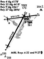
Runways
Runway Summary
| Runways: | 04/22 10/28 |
| Longest Runway: | 04/22 is 4552 ft (1387 m) long |
| Runways with an Instrument Approach: | 22 |
CDW Airport Runway Details
| Runway 04/22 | 4552 ft x 80 ft (1387 m x 24 m) | |
| Runway Length Source: | 3RD PARTY SURVEY as of 01/20/2021 | |
| Surface: | Asphalt - Good condition - Saw-cut or plastic grooved | |
| Runway Edge Lights: | High Intensity | |
Runway Weight Bearing Capacity (in thousands of pounds) |
||
| Single Wheel Landing Gear: | 30.0 | |
Runway 04 |
Runway 22 |
|
Elevation: |
172.0 | 172.1 |
Latitude: |
40-52-03.9363N | 40-52-43.0441N |
Longitude: |
074-17-10.8156W | 074-16-41.5382W |
|
Runway True Alignment: |
030 | 210 |
ILS Type: |
LOCALIZER | |
Glide Path Angle: |
0.0 degrees | 3.0 degrees |
Traffic Pattern: |
Left | Right |
Runway Markings Type: |
Nonprecision Instrument | Nonprecision Instrument |
Runway Markings Condition: |
Good | Good |
Object at End: |
TREE | TREES |
Object Height: |
45 | 90 |
Distance from End: |
220 | 400 |
Object Centerline Offset: |
137 ft. left of centerline | 245 ft. left and right of centerline |
Visual Glide Slope Indicators: |
4-Light PAPI On Right Side Of Runway | |
REIL: |
No | Yes |
Threshold Crossing Height: |
42 | |
Threshold Elevation: |
171.8 | 172.2 |
Displaced Threshold: |
375 | 135 |
Threshold Latitude: |
40-52-07.1549N | 40-52-41.8824N |
Threshold Longitude: |
074-17-08.4073W | 074-16-42.4080W |
| Runway 10/28 | 3719 ft x 75 ft (1134 m x 23 m) | |
| Runway Length Source: | 3RD PARTY SURVEY as of 12/16/2015 | |
| Surface: | Asphalt - Good condition - No special surface treatment | |
| Runway Edge Lights: | Medium Intensity | |
Runway Weight Bearing Capacity (in thousands of pounds) |
||
| Single Wheel Landing Gear: | 30.0 | |
Runway 10 |
Runway 28 |
|
Elevation: |
168.4 | 172.1 |
Latitude: |
40-52-37.5785N | 40-52-41.9578N |
Longitude: |
074-17-12.8323W | 074-16-24.7657W |
|
Runway True Alignment: |
083 | 263 |
Glide Path Angle: |
0.0 degrees | 0.0 degrees |
Traffic Pattern: |
Left | Right |
Runway Markings Type: |
Basic | Basic |
Runway Markings Condition: |
Good | Good |
Object at End: |
TREE | TREE |
Object Height: |
39 | 46 |
Distance from End: |
264 | 423 |
Object Centerline Offset: |
137 ft. left of centerline | 245 ft. left and right of centerline |
REIL: |
No | No |
Threshold Elevation: |
168.8 | 171.9 |
Displaced Threshold: |
344 | 550 |
Threshold Latitude: |
40-52-37.9866N | 40-52-41.3104N |
Threshold Longitude: |
074-17-08.3539W | 074-16-31.8744W |
Services
Airframe Repair: |
Major |
Powerplant Repair: |
Major |
Bottled Oxygen: |
None |
Bulk Oxygen: |
None |
Fuel Available: |
100LL |
Parking: |
Tiedowns available |
Maps & Diagrams
CDW Sectional
Flight Planning
at skyvector.com
at skyvector.com