Location
Latitude: |
42-04-26.2000N (42.073944) |
Longitude: |
124-17-23.2000W (-124.289778) |
Elevation: |
461.9 feet MSL (141 m MSL) |
Magnetic Variation: |
14.3 E (as of April 2024 from WMM2020 model) |
Time Zone: |
UTC -8.0 (Standard Time) UTC -7.0 (Daylight Savings Time) |
From City: |
01 N.M. NE of Brookings, Oregon |
Found On: |
Klamath Falls Chart |
FAA Region: |
ANM |
Contacts
Manager: |
Publicly owned: |
| JONATHAN TROST 898 ELK DR, SUITE 122 BROOKINGS, OR 97415 (541) 254-4278 |
CITY OF BROOKINGS 898 ELK DR BROOKINGS, OR 97415 541-254-4278 |
Operations
Airport Status: |
Operational |
Facility Use: |
Public |
Type: |
Airport |
Control tower: |
No |
Attendance (Months/Days/Hours): |
Months/Days/Hours Unattended |
Boundary ARTCC: |
ZSE (Seattle) |
Responsible ARTCC: |
ZSE (Seattle) |
Lighting Schedule: |
SEE RMK |
Segmented Circle Indicator: |
Yes |
Traffic Pattern Altitude (MSL): |
1462 feet (446 m) |
NOTAMs Facility: |
BOK |
NOTAM-D Service: |
Yes |
International Airport of Entry: |
No |
Customs Landing Rights: |
No |
Military Landing Rights: |
Yes |
Civil/Military Joint Use: |
No |
Based Aircraft
| Single Engine: | 14 |
| Multi Engine: | 2 |
| Jet Engine: | 1 |
| GA Helicopters: | 4 |
Annual Operations (as of 07/27/2020)
| Total Operations: | 22600 | |
| Air Taxi: | 1250 | 5.5% |
| GA Local: | 2250 | 10.0% |
| GA Itinerant: | 19000 | 84.1% |
| Military Aircraft: | 100 | 0.4% |
Communications
| CTAF: | 122.800 |
| Unicom: | 122.800 |
| AWOS-3PT: | 132.025 (541-412-8682) |
- APCH/DEP SVC PRVDD BY SEATTLE ARTCC (ZSE) ON 124.85/306.3 (ARCATA RCAG).
Fixed Based Operators (FBOs) & Fuel
(Click on a business for detail)
Please help us keep this information up to date. This is a FREE SERVICE just like everything else on Airport Guide! If you see that a business needs to be added, modified, or deleted please fill out our Update Form.
To add, modify, or delete a business click here.
Please help us keep this information up to date. This is a FREE SERVICE just like everything else on Airport Guide! If you see that a business needs to be added, modified, or deleted please fill out our Update Form.
Area Code: 541 |
| Business Name | Frequency | Phone | Fuel Grade |
|---|---|---|---|
| Brookings Flying Club
Update FBO info |
Unicom 122.8 | 469-4217 | 100LL, Jet A |
Flight Service Stations
| Primary | Alternate | |
| FSS on Field: | N | |
| FSS Name (ID): | Mc Minnville(MMV) | |
| Frequency: | ||
| Toll Free Phone: | 1-800-WX-BRIEF |
Instrument Procedures / Charts
FAA Terminal Procedures valid from 0901Z 03/21/24 to 0901Z 04/18/24.
There are various types of charts available for an airport. They are listed in the Page Type column. Here is a legend for those types:
APD - Airport Diagram
DP - Departure Procedure Charts
HOT - Hot Spots
IAP - Instrument Approach Procedure Charts
MIN - Minimums
STAR - Standard Terminal Arrival Charts
| Page Type | Page Name | Volume | Action Since Last Cycle |
|---|---|---|---|
| IAP | RNAV (GPS)-A | NW-1 | |
| MIN | ALTERNATE MINIMUMS | NW-1 | |
| MIN | TAKEOFF MINIMUMS | NW-1 |
Terminal Procedures are only available for airports in several countries with more being added all the time. If you are looking for a specific country's charts, please send an email to support(at)airportguide.com stating the country name. This will be used to prioritize the implementation.
Navigation Aids (Navaids) near BOK
| Dist (NM) | ID | Morse Code | Name | Type | Freq | True Hdg | Mag Hdg |
|---|---|---|---|---|---|---|---|
| 17.8 | CEC | _ . _ . . _ . _ . | Crescent City | VORTAC | 109.00 | 172 | 158 |
| 65.5 | MFR | _ _ . . _ . . _ . | Medford | VOT | 117.20 | 74 | 60 |
| 65.5 | MEF | _ _ . . . _ . | Medford | NDB | 356 | 72 | 58 |
| 65.8 | OED | _ _ _ . _ . . | Rogue Valley | VORTAC | 113.60 | 67 | 53 |
| 66.1 | ACV | . _ _ . _ . . . . _ | Arcata | VOR-DME | 115.05 | 172 | 158 |
| 76.2 | FJS | . . _ . . _ _ _ . . . | Fort Jones | VOR-DME | 116.25 | 118 | 104 |
| 78.3 | RBG | . _ . _ . . . _ _ . | Roseburg | VOR-DME | 108.20 | 31 | 17 |
| 79.2 | OT | _ _ _ _ | Emire | NDB | 378 | 359 | 345 |
| 80.7 | OTH | _ _ _ _ . . . . | North Bend | VOR-DME | 112.10 | 3 | 349 |
| 80.9 | RBG | . _ . _ . . . _ _ . | Roseburg | NDB | 400 | 30 | 16 |
| 83.4 | MOG | _ _ _ _ _ _ _ . | Montague | NDB | 404 | 103 | 89 |
| 84.2 | FOT | . . _ . _ _ _ _ | Fortuna | VORTAC | 114.00 | 178 | 164 |
Nearby Airports with Fuel
Notices to Airmen (NOTAMS)
Remarks
| A110-1 | DEER AND ELK INVOF ARPT GROUNDS. |
| A110-2 | FOR CD CTC SEATTLE ARTCC AT 253-351-3694. |
| A14 | ALT CTC: JONATHAN TROST PHONE: 541-247-3232 |
| A58-12 | 5 FT BRUSH LINE AT 180 FT FM RWY END BOTH SIDES OF CNTRLN. |
| A58-30 | 6 FT TO 20 FT BRUSH & TREES AT 0-200 FT FM RWY END & 80 FT L & R SIDES OF CNTRLN. |
| A80 | ARB LIGHT BEAM OBSCURED BY TALLER TREES NE-SE QUADRANT. |
| A81-APT | ACTVT MIRL RWY 12/30; PAPI RWY 12/30 - CTAF. |
Runways
Runway Summary
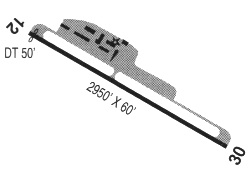
| Runways: | 12/30 |
| Longest Runway: | 12/30 is 2901 ft (884 m) long |
| Runways with an Instrument Approach: |
BOK Airport Runway Details
| Runway 12/30 | 2901 ft x 60 ft (884 m x 18 m) | |
| Runway Length Source: | 3RD PARTY SURVEY as of 11/16/2017 | |
| Surface: | Asphalt - Good condition - No special surface treatment | |
| Runway Edge Lights: | Medium Intensity | |
Runway Weight Bearing Capacity (in thousands of pounds) |
||
| Single Wheel Landing Gear: | 11.0 | |
Runway 12 |
Runway 30 |
|
Elevation: |
461.8 | 436.4 |
Latitude: |
42-04-37.6428N | 42-04-14.6474N |
Longitude: |
124-17-34.6707W | 124-17-11.7216W |
|
Runway True Alignment: |
144 | 324 |
Glide Path Angle: |
4.0 degrees | 3.0 degrees |
Traffic Pattern: |
Right | Left |
Runway Markings Type: |
Basic | Basic |
Runway Markings Condition: |
Fair | Fair |
Object at End: |
TREES | TREES |
Object Height: |
50 | 12 |
Distance from End: |
587 | 200 |
Object Centerline Offset: |
0 ft. left and right of centerline | 0 ft. left and right of centerline |
Visual Glide Slope Indicators: |
2-Light PAPI On Left Side Of Runway | 2-Light PAPI On Left Side Of Runway |
Threshold Crossing Height: |
40 | 45 |
Services
Bottled Oxygen: |
None |
Bulk Oxygen: |
None |
Fuel Available: |
100LL |
Landing Fees: |
No |
Parking: |
Tiedowns available |
Maps & Diagrams
BOK Sectional
Flight Planning
at skyvector.com
at skyvector.com