Location
Latitude: |
33-33-50.0000N (33.563889) |
Longitude: |
086-45-08.3000W (-86.752306) |
Elevation: |
650.0 feet MSL (198 m MSL) |
Magnetic Variation: |
3.9 W (as of April 2024 from WMM2020 model) |
Time Zone: |
UTC -6.0 (Standard Time) UTC -5.0 (Daylight Savings Time) |
From City: |
04 N.M. NE of Birmingham, Alabama |
Found On: |
Atlanta Chart |
FAA Region: |
ASO |
Contacts
Manager: |
Publicly owned: |
| RONALD MATHIEU BIRMINGHAM AIRPORT AUTHORITY, 5900 MESSER AIRPORT HWY BIRMINGHAM, AL 35212 (205) 599-0505 |
BIRMINGHAM AIRPORT AUTHORITY 5900 MESSER AIRPORT HWY BIRMINGHAM, AL 35212 (205) 599-0505 |
Operations
Airport Status: |
Operational |
Facility Use: |
Public |
Type: |
Airport |
Activation Date: |
04/1940 |
Control tower: |
Yes |
Attendance (Months/Days/Hours): |
Months/Days/Hours ALL/ALL/ALL |
Boundary ARTCC: |
ZTL (Atlanta) |
Responsible ARTCC: |
ZTL (Atlanta) |
Segmented Circle Indicator: |
No |
Traffic Pattern Altitude (MSL): |
1650 feet (503 m) |
NOTAMs Facility: |
BHM |
NOTAM-D Service: |
Yes |
International Airport of Entry: |
No |
Customs Landing Rights: |
Yes |
Military Landing Rights: |
Yes |
Civil/Military Joint Use: |
No |
Aircraft Rescue and Firefighting: |
Class I ARFF Index: C Air Carrier Service: Scheduled Certification Date: 05/1973 |
Based Aircraft
| Single Engine: | 73 |
| Multi Engine: | 43 |
| Jet Engine: | 102 |
| GA Helicopters: | 4 |
| Military Aircraft: | 8 |
Annual Operations (as of 12/31/2019)
| Total Operations: | 104847 | |
| Commercial: | 33994 | 32.4% |
| Air Taxi: | 20366 | 19.4% |
| GA Local: | 2354 | 2.2% |
| GA Itinerant: | 38096 | 36.3% |
| Military Aircraft: | 10037 | 9.6% |
Communications
| Unicom: | 122.950 |
| Tower: | BIRMINGHAM 119.9 317.725 118.25 Hrs: 24 |
| Clearance Del.: | 305.2 |
| Ground: | 121.7 348.6 |
| Approach: | BIRMINGHAM 123.8 ;050-230 127.675 ;231-049 256.8 ;050-230 338.2 ;231-049 Hrs: 24 |
| Departure: | BIRMINGHAM 123.8 ;050-230 127.675 ;231-049 256.8 ;050-230 338.2 ;231-049 Hrs: 24 |
| ATIS: | 119.4 270.1 Hrs: 24 |
| ASOS: | (205-591-6172) |
| CLASS C: | 127.675 ;231-049 |
| CLASS C: | 338.2 ;231-049 |
| EMERG: | 243.0 |
| SFA: | 396.0 |
| EMERG: | 121.5 |
| CLASS C: | 256.8 ;050-230 |
| SFA: | 294.7 |
| CLASS C: | 123.8 ;050-230 |
Fixed Based Operators (FBOs) & Fuel
(Click on a business for detail)
Please help us keep this information up to date. This is a FREE SERVICE just like everything else on Airport Guide! If you see that a business needs to be added, modified, or deleted please fill out our Update Form.
To add, modify, or delete a business click here.
Please help us keep this information up to date. This is a FREE SERVICE just like everything else on Airport Guide! If you see that a business needs to be added, modified, or deleted please fill out our Update Form.
Area Code: 205 |
| Business Name | Frequency | Phone | Fuel Grade |
|---|---|---|---|
| Mercury Air Center
Website Update FBO info |
599-7613, 800-458-3498 | 100LL, Jet A | |

|
Chevron |
100LL - 2.92 USD per gallon on 9/24/01 |
Trucks $0.30 per gallon discount for Angel Flights |
|
|
Chevron |
Jet A - 2.73 USD per gallon on 9/24/01 |
Trucks $0.30 per gallon discount for Angel Flights |
| Signature Flight Support
Website Update FBO info |
Arinc 131.97 | 849-5520 | 100LL, Jet A |
Flight Service Stations
| Primary | Alternate | |
| FSS on Field: | N | |
| FSS Name (ID): | Anniston(ANB) | |
| Frequency: | ||
| Toll Free Phone: | 1-800-WX-BRIEF |
Instrument Procedures / Charts
FAA Terminal Procedures valid from 0901Z 03/21/24 to 0901Z 04/18/24.
There are various types of charts available for an airport. They are listed in the Page Type column. Here is a legend for those types:
APD - Airport Diagram
DP - Departure Procedure Charts
HOT - Hot Spots
IAP - Instrument Approach Procedure Charts
MIN - Minimums
STAR - Standard Terminal Arrival Charts
| Page Type | Page Name | Volume | Action Since Last Cycle |
|---|---|---|---|
| APD | AIRPORT DIAGRAM | SE-4 | Changed |
| DP | BIRMINGHAM EIGHT | SE-4 | Changed |
| DP | BIRMINGHAM EIGHT[DELIMITER] CONT.1 | SE-4 | |
| IAP | ILS OR LOC RWY 06 | SE-4 | Changed |
| IAP | ILS OR LOC RWY 24 | SE-4 | Changed |
| IAP | ILS RWY 06 (CAT II) | SE-4 | Changed |
| IAP | ILS RWY 24 (SA CAT II) | SE-4 | Changed |
| IAP | LOC RWY 18 | SE-4 | Changed |
| IAP | RNAV (GPS) RWY 18 | SE-4 | Changed |
| IAP | RNAV (GPS) RWY 36 | SE-4 | Changed |
| IAP | RNAV (GPS) Y RWY 06 | SE-4 | Changed |
| IAP | RNAV (GPS) Y RWY 24 | SE-4 | Changed |
| IAP | RNAV (RNP) Z RWY 06 | SE-4 | Changed |
| IAP | RNAV (RNP) Z RWY 24 | SE-4 | Changed |
| LAH | LAHSO | SE-4 | |
| MIN | ALTERNATE MINIMUMS | SE-4 | |
| MIN | TAKEOFF MINIMUMS | SE-4 |
Terminal Procedures are only available for airports in several countries with more being added all the time. If you are looking for a specific country's charts, please send an email to support(at)airportguide.com stating the country name. This will be used to prioritize the implementation.
Navigation Aids (Navaids) near BHM
| Dist (NM) | ID | Morse Code | Name | Type | Freq | True Hdg | Mag Hdg |
|---|---|---|---|---|---|---|---|
| 0.2 | BHM | _ . . . . . . . _ _ | Birmingham Muni | VOT | 110.00 | 255 | 259 |
| 5.6 | BH | _ . . . . . . . | Mcden | NDB | 224 | 236 | 240 |
| 9.7 | VUZ | . . . _ . . _ _ _ . . | Vulcan | VORTAC | 114.40 | 310 | 314 |
| 31.7 | OKW | _ _ _ _ . _ . _ _ | Brookwood | VORTAC | 111.00 | 232 | 236 |
| 31.9 | SCD | . . . _ . _ . _ . . | Sylacauga | NDB | 284 | 136 | 140 |
| 35.5 | TDG | _ _ . . _ _ . | Talladega | DME | 108.8 | 88 | 92 |
| 41.1 | AN | . _ _ . | Bogga | NDB | 211 | 92 | 96 |
| 41.5 | GAD | _ _ . . _ _ . . | Gadsden | VOR-DME | 112.30 | 53 | 57 |
| 43.2 | GGY | _ _ . _ _ . _ . _ _ | Gragg-Wade | NDB | 338 | 170 | 174 |
| 43.3 | LDK | . _ . . _ . . _ . _ | Crimson | TACAN | 117.80 | 245 | 249 |
| 49.0 | ARF | . _ . _ . . . _ . | Saratoga | NDB | 296 | 32 | 36 |
| 52.0 | TC | _ _ . _ . | Tuske | NDB | 362 | 242 | 246 |
| 57.1 | DER | _ . . . . _ . | Alexander City | NDB | 382 | 135 | 139 |
| 64.6 | HSV | . . . . . . . . . . _ | Huntsville | VOT | 111.00 | 359 | 363 |
| 65.7 | DCU | _ . . _ . _ . . . _ | Decatur | DME | 112.8 | 351 | 355 |
| 68.2 | HUA | . . . . . . _ . _ | Redstone | NDB | 287 | 2 | 6 |
| 72.6 | CWH | _ . _ . . _ _ . . . . | Capshaw | NDB | 350 | 358 | 362 |
| 73.4 | HAB | . . . . . _ _ . . . | Hamilton | DME | 110.4 | 301 | 305 |
| 73.6 | MXF | _ _ _ . . _ . . _ . | Maxwell | TACAN | 115.00 | 164 | 168 |
| 74.1 | JYU | . _ _ _ _ . _ _ . . _ | Junior | VOR-DME | 113.60 | 189 | 193 |
Nearby Airports with Fuel
Notices to Airmen (NOTAMS)
Remarks
| A110-15 | TWY F BTN RWY 18/36 & TWY G RSTRD TO ACFT 100000 LBS OR LESS. |
| A110-16 | ANG: PPR RQR FOR ANG RAMP. NML OPR HRS 1300-2330Z++ TUE-FRI, CLSD WKNDS & HOL. NO SVC AVBL OUTSIDE THESE HRS WITHOUT PRIOR APVL. NO LCL OR ROUND-ROBIN FLT BY TRAN ACFT. CALL AIRFIELD OPS DSN 778-2555, C205-714-2555 FOR PPR 72 HR PRIOR (96 HRS FOR CARGO MSN). ALL INBD ACFT CTC ANG COMD POST 'VULCN CONTROL' NO LATER THAN 15 MIN PRIOR TO LDG WITH PPR NR AND SUPPORT REQ. SPACE-A CAPABILITIES EXTREMELY LTD, PAX SVC LTD AVAILABILITY. |
| A110-17 | TWY H S OF TWY H4 RSTRD TO ACFT WITH WINGSPAN LESS THAN 117 FT. |
| A110-18 | TWY A BTN TWY A HLDG BAY AND TWY A3 RSTRD TO ACFT WITH WINGSPAN LESS THAN 150 FT. |
| A110-2 | TWY G RSTRD TO ACFT 65000 LBS OR LESS. |
| A110-3 | TWY M N OF RWY 6/24 RSTRD TO ACFT 75000 LBS OR LESS. |
| A110-6 | TWY N RSTRD TO ACFT 204000 LBS OR LESS. |
| A110-7 | BIRD ACTV INVOF RWYS. |
| A49-24 | MALSR ATCT CTLD, OPS UMMONITORED. |
| A57-24 | APCH SLOPE 25:1 DUE TO 44 FT POLE, 4424 FT FROM DSPLCD THR. |
| A58-24 | NAVAID SHELTER 149 FT FM RWY END, 405 FT L, 1 FT ABV RWY END ELEV. |
| A70-FUEL-A | A++100 (MIL) |
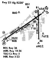
Runways
Runway Summary
| Runways: | 06/24 18/36 |
| Longest Runway: | 06/24 is 12007 ft (3660 m) long |
| Runways with an Instrument Approach: | 06, 24, 18 |
BHM Airport Runway Details
| Runway 06/24 | 12007 ft x 150 ft (3660 m x 46 m) | |
| Runway Length Source: | 3RD PARTY SURVEY as of 07/02/2015 | |
| Surface: | Asphalt - Good condition - Saw-cut or plastic grooved | |
| Runway Pavement Class: | 65 /F/C/X/T | |
| Runway Edge Lights: | High Intensity | |
Runway Weight Bearing Capacity (in thousands of pounds) |
||
| Single Wheel Landing Gear: | 175.0 | |
| Dual Wheel Landing Gear: | 205.0 | |
| Dual Tandem Wheel Landing Gear: | 350.0 | |
Runway 06 |
Runway 24 |
|
Elevation: |
603.4 | 650.0 |
Latitude: |
33-33-17.2063N | 33-34-24.5295N |
Longitude: |
086-46-17.6487W | 086-44-20.7487W |
|
Runway True Alignment: |
055 | 235 |
ILS Type: |
ILS | ILS/DME |
Glide Path Angle: |
3.0 degrees | 3.0 degrees |
Traffic Pattern: |
Left | Left |
Runway Markings Type: |
Precision Instrument | Precision Instrument |
Runway Markings Condition: |
Fair | Fair |
Object at End: |
TREES | GND |
Object Height: |
58 | 67 |
Distance from End: |
1290 | 1323 |
Object Centerline Offset: |
654 ft. right of centerline | 610 ft. right of centerline |
Visual Glide Slope Indicators: |
4-Light PAPI On Left Side Of Runway | 4-Light PAPI On Left Side Of Runway |
Runway Visual Range (RVR): |
Touchdown, Midfield, Rollout | Touchdown, Midfield, Rollout |
Approach Light System: |
Standard 2,400 Foot High Intensity Approach Lighting System With Sequenced Flashers, Cat. II or III Config. | 1,400 Foot Medium Intensity Approach Lighting System With Runway Alignment Indicator Lights |
Touchdown Lights: |
Yes | No |
Centerline Lights: |
Yes | Yes |
Threshold Crossing Height: |
68 | 69 |
Threshold Elevation: |
640.4 | |
Displaced Threshold: |
1205 | |
Threshold Latitude: |
33-34-17.7743N | |
Threshold Longitude: |
086-44-32.4867W | |
Declared Distances |
||
Take Off Run Avbl. (TORA): |
12007 | 12007 |
Take Off Distance Avbl. (TODA): |
12007 | 12007 |
Actual Stop Dist. Avbl. (ASDA): |
12007 | 12007 |
Landing Dist. Avbl. (LDA): |
12007 | 10801 |
| Runway 18/36 | 7099 ft x 150 ft (2164 m x 46 m) | |
| Runway Length Source: | 3RD PARTY SURVEY as of 07/02/2015 | |
| Surface: | Asphalt - Good condition - Saw-cut or plastic grooved | |
| Runway Pavement Class: | 45 /F/C/X/T | |
| Runway Edge Lights: | Medium Intensity | |
Runway Weight Bearing Capacity (in thousands of pounds) |
||
| Single Wheel Landing Gear: | 75.0 | |
| Dual Wheel Landing Gear: | 170.0 | |
| Dual Tandem Wheel Landing Gear: | 240.0 | |
Runway 18 |
Runway 36 |
|
Elevation: |
644.3 | 633.5 |
Latitude: |
33-34-23.5685N | 33-33-13.3386N |
Longitude: |
086-44-49.8849W | 086-44-49.9207W |
|
Runway True Alignment: |
180 | 000 |
ILS Type: |
LOC/DME | |
Glide Path Angle: |
3.2 degrees | 0.0 degrees |
Traffic Pattern: |
Left | Left |
Runway Markings Type: |
Nonprecision Instrument | Nonprecision Instrument |
Runway Markings Condition: |
Good | Good |
Object at End: |
TREES | TREES |
Object Height: |
245 | 62 |
Distance from End: |
5689 | 1340 |
Object Centerline Offset: |
654 ft. right of centerline | 610 ft. right of centerline |
Visual Glide Slope Indicators: |
4-Light PAPI On Left Side Of Runway | |
REIL: |
Yes | Yes |
Threshold Crossing Height: |
51 | |
Declared Distances |
||
Take Off Run Avbl. (TORA): |
7099 | 7099 |
Take Off Distance Avbl. (TODA): |
7099 | 7099 |
Actual Stop Dist. Avbl. (ASDA): |
7099 | 7099 |
Landing Dist. Avbl. (LDA): |
7099 | 7099 |
Services
Airframe Repair: |
Minor |
Powerplant Repair: |
Minor |
Bottled Oxygen: |
None |
Bulk Oxygen: |
None |
Fuel Available: |
100LL |
Landing Fees: |
No |
Parking: |
Tiedowns available |
Maps & Diagrams
BHM Sectional
Flight Planning
at skyvector.com
at skyvector.com