Location
Latitude: |
42-34-45.2000N (42.579222) |
Longitude: |
099-59-34.7000W (-99.992972) |
Elevation: |
2588.7 feet MSL (789 m MSL) |
Magnetic Variation: |
4.9 E (as of April 2024 from WMM2020 model) |
Time Zone: |
UTC -6.0 (Standard Time) UTC -5.0 (Daylight Savings Time) |
From City: |
06 N.M. NW of Ainsworth, Nebraska |
Found On: |
Omaha Chart |
FAA Region: |
ACE |
Contacts
Manager: |
Publicly owned: |
| LANCE SCHIPPOREIT PO BOX 84 AINSWORTH, NE 69210-0084 402-387-1491 |
AINSWORTH ARPT AUTH PO BOX 84 AINSWORTH, NE 69210-0084 402-387-1491 |
Operations
Airport Status: |
Operational |
Facility Use: |
Public |
Type: |
Airport |
Activation Date: |
12/1944 |
Control tower: |
No |
Attendance (Months/Days/Hours): |
Months/Days/Hours ALL/MON-FRI/0800-1700 |
Boundary ARTCC: |
ZDV (Denver) |
Responsible ARTCC: |
ZDV (Denver) |
Lighting Schedule: |
SEE RMK |
Segmented Circle Indicator: |
Yes |
Traffic Pattern Altitude (MSL): |
3589 feet (1094 m) |
NOTAMs Facility: |
ANW |
NOTAM-D Service: |
Yes |
International Airport of Entry: |
No |
Customs Landing Rights: |
No |
Military Landing Rights: |
Yes |
Civil/Military Joint Use: |
No |
Based Aircraft
| Single Engine: | 10 |
| Multi Engine: | 1 |
| Jet Engine: | 1 |
| GA Helicopters: | 1 |
Annual Operations (as of 08/07/2023)
| Total Operations: | 4000 | |
| GA Local: | 1300 | 32.5% |
| GA Itinerant: | 2650 | 66.2% |
| Military Aircraft: | 50 | 1.2% |
Communications
| CTAF: | 122.800 |
| Unicom: | 122.800 |
| AWOS-3: | 118.325 (402-387-2329) |
- APCH/DEP CTL SVC PRVDD BY DENVER ARTCC (ZDV) ON FREQ 127.95/338.2 (AINSWORTH RCAG).
Fixed Based Operators (FBOs) & Fuel
(Click on a business for detail)
Please help us keep this information up to date. This is a FREE SERVICE just like everything else on Airport Guide! If you see that a business needs to be added, modified, or deleted please fill out our Update Form.
To add, modify, or delete a business click here.
Please help us keep this information up to date. This is a FREE SERVICE just like everything else on Airport Guide! If you see that a business needs to be added, modified, or deleted please fill out our Update Form.
Area Code: 402 |
| Business Name | Frequency | Phone | Fuel Grade |
|---|---|---|---|
| Ainsworth Municipal Airport
Update FBO info |
Unicom 122.8 | 800-303-1491, 387-1491 | 100LL, Jet A |
Flight Service Stations
| Primary | Alternate | |
| FSS on Field: | N | |
| FSS Name (ID): | Columbus(OLU) | |
| Frequency: | ||
| Toll Free Phone: | 1-800-WX-BRIEF |
Instrument Procedures / Charts
FAA Terminal Procedures valid from 0901Z 03/21/24 to 0901Z 04/18/24.
There are various types of charts available for an airport. They are listed in the Page Type column. Here is a legend for those types:
APD - Airport Diagram
DP - Departure Procedure Charts
HOT - Hot Spots
IAP - Instrument Approach Procedure Charts
MIN - Minimums
STAR - Standard Terminal Arrival Charts
| Page Type | Page Name | Volume | Action Since Last Cycle |
|---|---|---|---|
| IAP | RNAV (GPS) RWY 13 | NC-2 | |
| IAP | RNAV (GPS) RWY 17 | NC-2 | |
| IAP | RNAV (GPS) RWY 31 | NC-2 | |
| IAP | RNAV (GPS) RWY 35 | NC-2 | |
| IAP | VOR RWY 17 | NC-2 | |
| IAP | VOR RWY 35 | NC-2 | |
| MIN | ALTERNATE MINIMUMS | NC-2 | |
| MIN | TAKEOFF MINIMUMS | NC-2 |
Terminal Procedures are only available for airports in several countries with more being added all the time. If you are looking for a specific country's charts, please send an email to support(at)airportguide.com stating the country name. This will be used to prioritize the implementation.
Navigation Aids (Navaids) near ANW
| Dist (NM) | ID | Morse Code | Name | Type | Freq | True Hdg | Mag Hdg |
|---|---|---|---|---|---|---|---|
| 0.6 | ANW | . _ _ . . _ _ | Ainsworth | VOR-DME | 112.70 | 166 | 161 |
| 18.3 | RBE | . _ . _ . . . . | Rock County | NDB | 341 | 90 | 85 |
| 29.8 | VTN | . . . _ _ _ . | Valentine | NDB | 314 | 304 | 299 |
| 48.2 | TDD | _ _ . . _ . . | Thedford | VOR-DME | 108.60 | 222 | 217 |
| 55.5 | ISD | . . . . . _ . . | Winner | VOR | 112.80 | 10 | 5 |
| 58.1 | ONL | _ _ _ _ . . _ . . | O'neill | VORTAC | 113.90 | 96 | 92 |
| 61.2 | BUB | _ . . . . . _ _ . . . | Burwell | NDB | 377 | 141 | 136 |
| 67.1 | CUZ | _ . _ . . . _ _ _ . . | Custer County | VOR-DME | 108.20 | 168 | 163 |
| 73.8 | ODX | _ _ _ _ . . _ . . _ | Ord | NDB | 356 | 140 | 135 |
| 80.2 | AGZ | . _ _ _ . _ _ . . | Wagner | NDB | 392 | 68 | 64 |
| 94.3 | LB | . _ . . _ . . . | Panbe | NDB | 416 | 196 | 191 |
| 97.3 | GRN | _ _ . . _ . _ . | Gordon | NDB | 414 | 278 | 272 |
| 97.8 | LBF | . _ . . _ . . . . . _ . | North Platte | VOR-DME | 117.40 | 200 | 195 |
Nearby Airports with Fuel
Notices to Airmen (NOTAMS)
Remarks
| A110-2 | HELIPAD FOR REFUELING ONLY. NOT AVBL FOR INST APCHS. |
| A110-3 | SEASONAL MIGRATORY WATERFOWL ON & INVOF ARPT. |
| A110-4 | FOR CD CTC DENVER ARTCC ON FREQ. IF UNA, CTC FSS ON FREQ VIA RCO. IF UNA, CTC DENVER ARTCC AT 303-651-4257. |
| A13 | ARPT MGR. |
| A16 | AMGR HOME PHONE 402-387-1255/1-800-303-1491. ON CALL. |
| A54-17 | BERM IS ACTUALLY 4.5 FT; WHICH GIVES THE 32:1 OBSTN CLNC SLOPE. |
| A70-FUEL-10 | 0LL 24 HR SELF SVC FUEL AVBL VIA CREDIT CARD SYSTEM. |
| A81-APT | ACTVT MALSR RWY 17 & 35; REIL RWY 31; PAPI RWY 13 & 31, 17 & 35 & HIRL 13/31 & RWY 17/35 - CTAF. |
| E111 | PRVDD CLEAR APCH/DEP PATHS FOR A MIN 8:1 GLIDE SLOPE; CLEAR TRANSITIONAL SFC FOR A MIN 2:1 SLOPE; AFTER IFR APCH & FOR VFR OPS AIR TAXI RTES OVER ESTABLISHED RYS OR TWYS; NO INGRESS/EGRESS OVER HANGERS OR OTHER BLDGS. |
Runways
Runway Summary
| Runways: | 13/31 17/35 H1 |
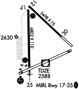
| Longest Runway: | 17/35 is 6824 ft (2080 m) long |
| Runways with an Instrument Approach: |
ANW Airport Runway Details
| Runway 13/31 | 5501 ft x 75 ft (1677 m x 23 m) | |
| Surface: | Asphalt - Good condition - No special surface treatment | |
| Runway Edge Lights: | High Intensity | |
Runway Weight Bearing Capacity (in thousands of pounds) |
||
| Single Wheel Landing Gear: | 24.0 | |
| Dual Wheel Landing Gear: | 36.0 | |
Runway 13 |
Runway 31 |
|
Elevation: |
2586.7 | 2582.6 |
Latitude: |
42-35-15.1503N | 42-34-37.1825N |
Longitude: |
099-59-45.1889W | 099-58-52.5910W |
|
Runway True Alignment: |
134 | 314 |
Glide Path Angle: |
3.0 degrees | 3.0 degrees |
Traffic Pattern: |
Left | Left |
Runway Markings Type: |
Nonprecision Instrument | Nonprecision Instrument |
Runway Markings Condition: |
Good | Fair |
Visual Glide Slope Indicators: |
2-Light PAPI On Left Side Of Runway | 2-Light PAPI On Left Side Of Runway |
REIL: |
No | Yes |
Threshold Crossing Height: |
50 | 52 |
| Runway 17/35 | 6824 ft x 110 ft (2080 m x 34 m) | |
| Surface: | Asphalt - Good condition - No special surface treatment | |
| Runway Edge Lights: | High Intensity | |
Runway Weight Bearing Capacity (in thousands of pounds) |
||
| Single Wheel Landing Gear: | 30.0 | |
| Dual Wheel Landing Gear: | 45.0 | |
Runway 17 |
Runway 35 |
|
Elevation: |
2586.5 | 2588.4 |
Latitude: |
42-35-10.0917N | 42-34-02.7020N |
Longitude: |
099-59-47.9516W | 099-59-46.8763W |
|
Runway True Alignment: |
179 | 359 |
Glide Path Angle: |
3.0 degrees | 3.0 degrees |
Traffic Pattern: |
Left | Left |
Runway Markings Type: |
Precision Instrument | Precision Instrument |
Runway Markings Condition: |
Good | Good |
Object at End: |
BERM | TREES |
Object Height: |
5 | 48 |
Distance from End: |
347 | 2259 |
Visual Glide Slope Indicators: |
4-Light PAPI On Left Side Of Runway | 4-Light PAPI On Left Side Of Runway |
Approach Light System: |
1,400 Foot Medium Intensity Approach Lighting System With Runway Alignment Indicator Lights | 1,400 Foot Medium Intensity Approach Lighting System With Runway Alignment Indicator Lights |
Threshold Crossing Height: |
46 | 45 |
| Helipad H1 | 50 ft x 50 ft (15 m x 15 m) | |
| Surface: | Asphalt - Good condition - No special surface treatment | |
Helipad H1 |
||
Elevation: |
2582.0 | |
Latitude: |
42-34-36.7600N | |
Longitude: |
100-00-01.4200W | |
Glide Path Angle: |
0.0 degrees | 0.0 degrees |
Services
Bottled Oxygen: |
None |
Bulk Oxygen: |
None |
Fuel Available: |
100LL |
Landing Fees: |
No |
Parking: |
Hangars and tiedowns available |
Maps & Diagrams
ANW Sectional
Flight Planning
at skyvector.com
at skyvector.com