Location
Latitude: |
29-45-30.7570N (29.758544) |
Longitude: |
085-17-20.7050W (-85.289085) |
Elevation: |
13.0 feet MSL (4 m MSL) |
Magnetic Variation: |
4.5 W (as of April 2024 from WMM2020 model) |
Time Zone: |
UTC -5.0 (Standard Time) UTC -4.0 (Daylight Savings Time) |
From City: |
02 N.M. S of Port St. Joe, Florida |
Found On: |
New Orleans Chart |
FAA Region: |
ASO |
Contacts
Manager: |
Privately owned: |
| M F LAWSON COSTIN AIRPORT, 167 CESSNA DRIVE PORT SAINT JOE, FL 32456 (850) 588-1747 |
SKYBORNE TECHNOLOGY INVEST PROP, I 115 COUNTY ROAD 381 PORT SAINT JOE, FL 32456 850-227-4933 |
Operations
Airport Status: |
Operational |
Facility Use: |
Public |
Type: |
Airport |
Activation Date: |
08/1985 |
Control tower: |
No |
Attendance (Months/Days/Hours): |
Months/Days/Hours UNATTND |
Boundary ARTCC: |
ZJX (Jacksonville) |
Responsible ARTCC: |
ZJX (Jacksonville) |
Segmented Circle Indicator: |
No |
Traffic Pattern Altitude (MSL): |
1013 feet (309 m) |
NOTAMs Facility: |
GNV |
NOTAM-D Service: |
Yes |
Based Aircraft
| Single Engine: | 5 |
Annual Operations (as of 04/03/2018)
| Total Operations: | 3250 | |
| GA Local: | 1200 | 36.9% |
| GA Itinerant: | 2000 | 61.5% |
| Military Aircraft: | 50 | 1.5% |
Communications
| CTAF: | 122.900 |
Fixed Based Operators (FBOs) & Fuel
(Click on a business for detail)
Please help us keep this information up to date. This is a FREE SERVICE just like everything else on Airport Guide! If you see that a business needs to be added, modified, or deleted please fill out our Update Form.
To add, modify, or delete a business click here.
Please help us keep this information up to date. This is a FREE SERVICE just like everything else on Airport Guide! If you see that a business needs to be added, modified, or deleted please fill out our Update Form.
Area Code: 850 |
| Business Name | Frequency | Phone | Fuel Grade |
|---|---|---|---|
| Gulf Aviation, Inc.
Update FBO info |
Unicom 122.9 | 227-1232 | 100LL |
Flight Service Stations
| Primary | Alternate | |
| FSS on Field: | N | |
| FSS Name (ID): | Gainesville(GNV) | |
| Frequency: | ||
| Toll Free Phone: | 1-800-WX-BRIEF |
Instrument Procedures / Charts
Terminal Procedures are only available for airports in several countries with more being added all the time. If you are looking for a specific country's charts, please send an email to support(at)airportguide.com stating the country name. This will be used to prioritize the implementation.
Navigation Aids (Navaids) near A51
| Dist (NM) | ID | Morse Code | Name | Type | Freq | True Hdg | Mag Hdg |
|---|---|---|---|---|---|---|---|
| 13.8 | AAF | . _ . _ . . _ . | Apalachicola | NDB | 349 | 98 | 103 |
| 24.0 | PAM | . _ _ . . _ _ _ | Tyndall | TACAN | 133.70 | 322 | 326 |
| 42.6 | PFN | . _ _ . . . _ . _ . | Lynne | NDB | 278 | 323 | 327 |
| 59.1 | TL | _ . _ . . | Wakul | NDB | 379 | 54 | 59 |
| 61.4 | TLH | _ . _ . . . . . . | Tallahassee Muni | VOT | 111.00 | 51 | 56 |
| 62.2 | MAI | _ _ . _ . . | Marianna | VORTAC | 114.00 | 7 | 12 |
| 66.9 | SMY | . . . _ _ _ . _ _ | Soyya | NDB | 329 | 2 | 7 |
| 67.4 | SZW | . . . _ _ . . . _ _ | Seminole | VORTAC | 117.50 | 44 | 49 |
| 67.5 | BKK | _ . . . _ . _ _ . _ | Tri County | NDB | 275 | 346 | 350 |
| 77.1 | DWG | _ . . . _ _ _ _ . | Warrington | TACAN | 134.50 | 304 | 308 |
| 82.9 | LYZ | . _ . . _ . _ _ _ _ . . | Willis | NDB | 359 | 28 | 33 |
| 83.1 | HRT | . . . . . _ . _ | Hurlburt | TACAN | 110.80 | 299 | 303 |
| 89.5 | CYR | _ . _ . _ . _ _ . _ . | Caidy | NDB | 338 | 40 | 45 |
| 91.5 | GEF | _ _ . . . . _ . | Greenville | VORTAC | 113.65 | 58 | 63 |
| 91.9 | RRS | . _ . . _ . . . . | Wiregrass | VORTAC | 111.60 | 355 | 360 |
| 92.1 | CE | _ . _ . . | Kobra | NDB | 201 | 315 | 319 |
| 92.1 | OZ | _ _ _ _ _ . . | Brynt | NDB | 212 | 342 | 346 |
| 93.4 | OZR | _ _ _ _ _ . . . _ . | Cairns | VOR-DME | 111.20 | 346 | 350 |
| 96.4 | CEW | _ . _ . . . _ _ | Crestview | VORTAC | 115.90 | 312 | 316 |
| 97.6 | EDN | . _ . . _ . | Enterprise | VOR | 116.60 | 341 | 345 |
Nearby Airports with Fuel
Notices to Airmen (NOTAMS)
Remarks
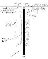
| A110-1 | 550' RADIO TWR LCTD 1 1/2 MILES NORTH OF ARPT. |
| A110-2 | NO TOUCH & GO LNDGS. |
| A110-3 | WTR-FILLED DITCH 60 FT WEST OF RWY. |
| A110-4 | FOR CD CTC TYNDALL APCH AT 850-283-2900 OR 850-283-3353, WHEN APCH CLSD CTC JACKSONVILLE ARTCC AT 904-845-1592. |
| A14 | FBO |
| A33-18/36 | SOUTH 1000 FT ROUGH, SOFT & SANDY. |
| A42-18 | RWY 18/36 MKD WITH WHITE PVC PIPES. |
| A57-18 | RWY 18 APCH RATIO 25:1 TO DTHR. |
| A57-36 | RWY 36 APCH RATIO 24:1 TO DTHR. |
| E111 | VFR USE ONLY. |
Runways
Runway Summary
| Runways: | 18/36 |
| Longest Runway: | 18/36 is 4230 ft (1289 m) long |
| Runways with an Instrument Approach: |
A51 Airport Runway Details
| Runway 18/36 | 4230 ft x 65 ft (1289 m x 20 m) | |
| Surface: | Turf - Fair condition - No special surface treatment | |
Runway 18 |
Runway 36 |
|
Glide Path Angle: |
0.0 degrees | 0.0 degrees |
Object at End: |
TREES | TREES |
Object Height: |
57 | 42 |
Distance from End: |
635 | 200 |
Object Centerline Offset: |
120 ft. left of centerline | 50 ft. right of centerline |
Displaced Threshold: |
660 | 1000 |
Services
Airframe Repair: |
Minor |
Powerplant Repair: |
Minor |
Bottled Oxygen: |
None |
Bulk Oxygen: |
None |
Fuel Available: |
100LL, Jet A+ |
Landing Fees: |
No |
Parking: |
Tiedowns available |
Maps & Diagrams
A51 Sectional
Flight Planning
at skyvector.com
at skyvector.com