Location
Latitude: |
39-50-51.4000N (39.847611) |
Longitude: |
096-07-00.9000W (-96.116917) |
Elevation: |
1291.0 feet MSL (393 m MSL) |
Magnetic Variation: |
2.2 E (as of April 2024 from WMM2020 model) |
Time Zone: |
UTC -6.0 (Standard Time) UTC -5.0 (Daylight Savings Time) |
From City: |
03 N.M. W of Seneca, Kansas |
Found On: |
Kansas City Chart |
FAA Region: |
ACE |
Contacts
Manager: |
Publicly owned: |
| BRIAN RUSCHE 531 MAIN ST. SENECA, KS 66538 785-336-3537 |
CITY OF SENECA 531 MAIN ST. SENECA, KS 66538 785-336-2747 |
Operations
Airport Status: |
Operational |
Facility Use: |
Public |
Type: |
Airport |
Control tower: |
No |
Attendance (Months/Days/Hours): |
Months/Days/Hours Unattended |
Boundary ARTCC: |
ZKC (Kansas City) |
Responsible ARTCC: |
ZKC (Kansas City) |
Lighting Schedule: |
SS-SR |
Segmented Circle Indicator: |
No |
Traffic Pattern Altitude (MSL): |
2291 feet (698 m) |
NOTAMs Facility: |
ICT |
NOTAM-D Service: |
Yes |
Civil/Military Joint Use: |
No |
Based Aircraft
Annual Operations (as of 08/31/2017)
| Total Operations: | 300 | |
| GA Local: | 200 | 66.7% |
| GA Itinerant: | 100 | 33.3% |
Communications
| CTAF: | 122.900 |
Fixed Based Operators (FBOs) & Fuel
(Click on a business for detail)
Please help us keep this information up to date. This is a FREE SERVICE just like everything else on Airport Guide! If you see that a business needs to be added, modified, or deleted please fill out our Update Form.
To add, modify, or delete a business click here.
Please help us keep this information up to date. This is a FREE SERVICE just like everything else on Airport Guide! If you see that a business needs to be added, modified, or deleted please fill out our Update Form.
Area Code: 785 |
| Business Name | Frequency | Phone | Fuel Grade |
|---|
Flight Service Stations
| Primary | Alternate | |
| FSS on Field: | N | |
| FSS Name (ID): | Wichita(ICT) | |
| Frequency: | ||
| Toll Free Phone: | 1-800-WX-BRIEF |
Instrument Procedures / Charts
Terminal Procedures are only available for airports in several countries with more being added all the time. If you are looking for a specific country's charts, please send an email to support(at)airportguide.com stating the country name. This will be used to prioritize the implementation.
Navigation Aids (Navaids) near 62K
| Dist (NM) | ID | Morse Code | Name | Type | Freq | True Hdg | Mag Hdg |
|---|---|---|---|---|---|---|---|
| 21.6 | PWE | . _ _ . . _ _ . | Pawnee City | DME | 112.4 | 349 | 347 |
| 28.0 | FNB | . . _ . _ . _ . . . | Brenner | NDB | 404 | 60 | 58 |
| 31.9 | RBA | . _ . _ . . . . _ | Robinson | DME | 108.2 | 89 | 87 |
| 40.0 | BIE | _ . . . . . . | Beatrice | VOR | 110.60 | 313 | 311 |
| 47.0 | AFK | . _ . . _ . _ . _ | Nebraska City | NDB | 347 | 14 | 12 |
| 48.0 | TO | _ _ _ _ | Biloy | NDB | 521 | 155 | 153 |
| 49.3 | MHK | _ _ . . . . _ . _ | Manhattan | VOR-DME | 110.20 | 211 | 209 |
| 50.1 | TOP | _ _ _ _ . _ _ . | Topeka | VORTAC | 117.80 | 148 | 146 |
| 52.1 | FBY | . . _ . _ . . . _ . _ _ | Fairbury | NDB | 293 | 292 | 289 |
| 55.3 | STJ | . . . _ . _ _ _ | St Joseph | VORTAC | 115.50 | 82 | 80 |
| 55.7 | AZN | . _ _ _ . . _ . | Amazon | NDB | 233 | 87 | 85 |
| 55.8 | CYW | _ . _ . _ . _ _ . _ _ | Clay Center | NDB | 362 | 240 | 237 |
| 56.8 | ST | . . . _ | Tario | NDB | 260 | 100 | 98 |
| 57.7 | FOE | . . _ . _ _ _ . | Forbes | VOT | 111.00 | 158 | 156 |
| 58.0 | FOE | . . _ . _ _ _ . | Forbes | TACAN | 111.60 | 158 | 156 |
| 58.4 | CVY | _ . _ . . . . _ _ . _ _ | Cavalry | NDB | 314 | 212 | 210 |
| 61.5 | LN | . _ . . _ . | Potts | NDB | 385 | 331 | 329 |
| 62.9 | FO | . . _ . _ _ _ | Riply | NDB | 326 | 156 | 154 |
| 62.9 | FRI | . . _ . . _ . . . | Fort Riley | VOR | 109.40 | 213 | 211 |
| 63.2 | SDA | . . . _ . . . _ | Shenandoah | NDB | 411 | 30 | 28 |
Nearby Airports with Fuel
Notices to Airmen (NOTAMS)
Remarks
| A110-1 | ULTRALGT ACTVTY ON & INVOF ARPT. |
| A110-2 | FOR CD CTC KANSAS CITY ARTCC AT 913-254-8508. |
| A17 | CALL 785-336-2141 FOR ARPT ACCESS. |
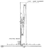
| A30-18/36 | RY 36 3.5% INCLINE FIRST 1,000 FT; REMAINDER 2% INCLINE. |
| A33-18/36 | RWY 18/36 N 1050 FT ROUGH TO INTERSECTION WITH TWY |
| A40-18/36 | NSTD LIRL; SPACING MORE THAN 200 FT APART; RY END LGTS ORANGE; AER 18 HAS ONLY 3 RY END LGTS. |
| A52-18 | FENCE AER 18 MKD WITH WHITE REFLECTORS. |
| A75 | AREA ONLY. NO ANCHORS OR ROPES. |
Runways
Runway Summary
| Runways: | 18/36 |
| Longest Runway: | 18/36 is 2400 ft (732 m) long |
| Runways with an Instrument Approach: |
62K Airport Runway Details
| Runway 18/36 | 2400 ft x 100 ft (732 m x 30 m) | |
| Surface: | Turf - Fair condition - No special surface treatment | |
| Runway Edge Lights: | Non-standard lighting system Intensity | |
Runway 18 |
Runway 36 |
|
Elevation: |
1291.0 | 1270.0 |
Latitude: |
39-51-03.2307N | 39-50-39.5829N |
Longitude: |
096-06-59.6604W | 096-07-02.1296W |
|
Runway True Alignment: |
185 | 005 |
Glide Path Angle: |
0.0 degrees | 0.0 degrees |
Traffic Pattern: |
Left | Left |
Object at End: |
FENCE | TREES |
Object Height: |
5 | 51 |
Object Marked/Lighted?: |
Marked | |
Distance from End: |
192 | 926 |
Object Centerline Offset: |
0 ft. left and right of centerline | 194 ft. left of centerline |
Services
Airframe Repair: |
Major |
Powerplant Repair: |
Major |
Fuel Available: |
MOGAS |
Landing Fees: |
No |
Parking: |
Tiedowns available |
Maps & Diagrams
62K Sectional
Flight Planning
at skyvector.com
at skyvector.com