Location
Latitude: |
46-51-14.2000N (46.853944) |
Longitude: |
097-12-28.3000W (-97.207861) |
Elevation: |
933.3 feet MSL (284 m MSL) |
Magnetic Variation: |
2.9 E (as of April 2024 from WMM2020 model) |
Time Zone: |
UTC -6.0 (Standard Time) UTC -5.0 (Daylight Savings Time) |
From City: |
04 N.M. S of Casselton, North Dakota |
Found On: |
Twin Cities Chart |
FAA Region: |
AGL |
Contacts
Manager: |
Publicly owned: |
| BOB MILLER BOX 64 CASSELTON, ND 58012 (701) 799-4606 |
CASSELTON REGIONAL APT AUTH C/O CHRMN - BOX 234 CASSELTON, ND 58012 701-347-0201 |
Operations
Airport Status: |
Operational |
Facility Use: |
Public |
Type: |
Airport |
Activation Date: |
04/1986 |
Control tower: |
No |
Attendance (Months/Days/Hours): |
Months/Days/Hours OCT-MAY/MON-SAT/0800-1700 |
Boundary ARTCC: |
ZMP (Minneapolis) |
Responsible ARTCC: |
ZMP (Minneapolis) |
Lighting Schedule: |
SEE RMK |
Segmented Circle Indicator: |
Yes |
Traffic Pattern Altitude (MSL): |
1933 feet (589 m) |
NOTAMs Facility: |
GFK |
NOTAM-D Service: |
Yes |
Based Aircraft
| Single Engine: | 38 |
| Multi Engine: | 1 |
| GA Helicopters: | 1 |
| Gliders: | 1 |
Annual Operations (as of 06/15/2020)
| Total Operations: | 15900 | |
| Air Taxi: | 200 | 1.3% |
| GA Local: | 12000 | 75.5% |
| GA Itinerant: | 3000 | 18.9% |
| Military Aircraft: | 700 | 4.4% |
Communications
| CTAF: | 122.800 |
| Unicom: | 122.800 |
| Approach: | FARGO 120.4 120.4 |
| Departure: | FARGO 120.4 120.4 |
Fixed Based Operators (FBOs) & Fuel
(Click on a business for detail)
Please help us keep this information up to date. This is a FREE SERVICE just like everything else on Airport Guide! If you see that a business needs to be added, modified, or deleted please fill out our Update Form.
To add, modify, or delete a business click here.
Please help us keep this information up to date. This is a FREE SERVICE just like everything else on Airport Guide! If you see that a business needs to be added, modified, or deleted please fill out our Update Form.
Area Code: 701 |
| Business Name | Frequency | Phone | Fuel Grade |
|---|
Flight Service Stations
| Primary | Alternate | |
| FSS on Field: | N | |
| FSS Name (ID): | Grand Forks(GFK) | |
| Frequency: | ||
| Toll Free Phone: | 1-800-WX-BRIEF |
Instrument Procedures / Charts
FAA Terminal Procedures valid from 0901Z 03/21/24 to 0901Z 04/18/24.
There are various types of charts available for an airport. They are listed in the Page Type column. Here is a legend for those types:
APD - Airport Diagram
DP - Departure Procedure Charts
HOT - Hot Spots
IAP - Instrument Approach Procedure Charts
MIN - Minimums
STAR - Standard Terminal Arrival Charts
| Page Type | Page Name | Volume | Action Since Last Cycle |
|---|---|---|---|
| IAP | RNAV (GPS) RWY 13 | NC-1 | |
| IAP | RNAV (GPS) RWY 31 | NC-1 | |
| IAP | VOR/DME RWY 31 | NC-1 | |
| MIN | TAKEOFF MINIMUMS | NC-1 |
Terminal Procedures are only available for airports in several countries with more being added all the time. If you are looking for a specific country's charts, please send an email to support(at)airportguide.com stating the country name. This will be used to prioritize the implementation.
Navigation Aids (Navaids) near 5N8
| Dist (NM) | ID | Morse Code | Name | Type | Freq | True Hdg | Mag Hdg |
|---|---|---|---|---|---|---|---|
| 15.8 | FAR | . . _ . . _ . _ . | Fargo | VOR-DME | 116.20 | 112 | 109 |
| 18.6 | AA | . _ . _ | Kenie | NDB | 365 | 59 | 56 |
| 41.9 | GWR | _ _ . . _ _ . _ . | Gwinner | NDB | 278 | 205 | 202 |
| 44.2 | BWP | _ . . . . _ _ . _ _ . | Breckenridge-Wahpeton | NDB | 233 | 145 | 142 |
| 54.2 | DTL | _ . . _ . _ . . | Detroit Lakes | VOR-DME | 111.20 | 91 | 89 |
| 55.0 | FFM | . . _ . . . _ . _ _ | Fergus Falls | VOR-DME | 110.40 | 127 | 125 |
| 56.3 | JM | . _ _ _ _ _ | Sabon | NDB | 395 | 271 | 268 |
| 59.6 | GF | _ _ . . . _ . | Hiser | NDB | 345 | 1 | 358 |
| 60.5 | JMS | . _ _ _ _ _ . . . | Jamestown | VOR-DME | 114.50 | 275 | 272 |
| 60.8 | FF | . . _ . . . _ . | Hamre | NDB | 337 | 128 | 126 |
| 63.9 | CKN | _ . _ . _ . _ _ . | Crookston | NDB | 400 | 21 | 18 |
| 66.1 | GFK | _ _ . . . _ . _ . _ | Grand Forks | VOR-DME | 114.30 | 0 | 357 |
| 66.7 | RDR | . _ . _ . . . _ . | Red River | TACAN | 116.40 | 353 | 350 |
| 69.8 | ETH | . _ . . . . | Wheaton | NDB | 326 | 156 | 153 |
| 73.3 | FSE | . . _ . . . . . | Fosston | NDB | 224 | 52 | 50 |
| 82.6 | HY | . . . . _ . _ _ | Harvi | NDB | 260 | 32 | 30 |
| 83.9 | TVF | _ . . . _ . . _ . | Thief River Falls | VOR-DME | 114.45 | 29 | 27 |
| 87.7 | PKD | . _ _ . _ . _ _ . . | Park Rapids | DME | 110.6 | 87 | 85 |
| 91.6 | PK | . _ _ . _ . _ | Spida | NDB | 269 | 89 | 87 |
| 92.9 | MOX | _ _ _ _ _ _ . . _ | Morris | VOR-DME | 109.60 | 145 | 143 |
Nearby Airports with Fuel
Notices to Airmen (NOTAMS)
Remarks
| A110-1 | CONFIRM WINTER CONDS & SNOW REMOVAL CALL 701-347-4680 BTN 0800-1700. |
| A110-2 | NUMEROUS AGRICULTURAL OPNS MAY-OCT. |
| A110-4 | ACFT PAINT SHOP AVBL 701-347-5262. |
| A110-5 | FOR CD CTC FARGO APCH AT 701-235-8894. |
| A16 | ADNL PHONE 701-799-4606/701-347-5519/701-347-4680/701-799-5782. |
| A17 | FOR ARPT ATTENDANCE AFT HRS CALL 701-347-5519/4680. |
| A70-FUEL-10 | 0LL SELF-SCC CREDIT CARD 100LL FUEL AVBL 24 HRS. |
| A81-APT | ACTVT REIL RWY 31; PAPI RWY 13; MIRL RWY 13/31 - CTAF. |
Runways
Runway Summary
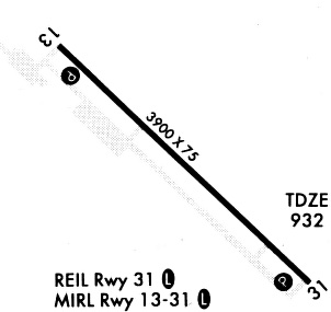
| Runways: | 13/31 |
| Longest Runway: | 13/31 is 3901 ft (1189 m) long |
| Runways with an Instrument Approach: |
5N8 Airport Runway Details
| Runway 13/31 | 3901 ft x 75 ft (1189 m x 23 m) | |
| Runway Length Source: | 3RD PARTY SURVEY as of 09/30/2016 | |
| Surface: | Concrete - Fair condition - No special surface treatment | |
| Runway Edge Lights: | Medium Intensity | |
Runway Weight Bearing Capacity (in thousands of pounds) |
||
| Single Wheel Landing Gear: | 12.5 | |
Runway 13 |
Runway 31 |
|
Elevation: |
933.0 | 927.8 |
Latitude: |
46-51-27.6461N | 46-51-00.7093N |
Longitude: |
097-12-48.3385W | 097-12-08.2442W |
|
Runway True Alignment: |
134 | 314 |
Glide Path Angle: |
3.0 degrees | 3.0 degrees |
Runway Markings Type: |
Nonprecision Instrument | Nonprecision Instrument |
Runway Markings Condition: |
Good | Good |
Visual Glide Slope Indicators: |
2-Light PAPI On Right Side Of Runway | 2-Light PAPI On Left Side Of Runway |
REIL: |
Yes | |
Threshold Crossing Height: |
21 | 22 |
Services
Airframe Repair: |
Major |
Powerplant Repair: |
Major |
Bottled Oxygen: |
None |
Bulk Oxygen: |
None |
Fuel Available: |
100LL |
Landing Fees: |
No |
Parking: |
Hangars and tiedowns available |
Maps & Diagrams
5N8 Sectional
Flight Planning
at skyvector.com
at skyvector.com