Location
Latitude: |
45-40-21.9964N (45.672777) |
Longitude: |
121-32-01.9099W (-121.533864) |
Elevation: |
638.0 feet MSL (194 m MSL) |
Magnetic Variation: |
14.6 E (as of April 2024 from WMM2020 model) |
Time Zone: |
UTC -8.0 (Standard Time) UTC -7.0 (Daylight Savings Time) |
From City: |
02 N.M. S of Hood River, Oregon |
Found On: |
Seattle Chart |
FAA Region: |
ANM |
Contacts
Manager: |
Publicly owned: |
| GREG HAGBERY 1000 E. PORT MARINA DRIVE HOOD RIVER, OR 97031 541-386-1645 |
PORT OF HOOD RIVER 1000 E. PORT MARINA DRIVE HOOD RIVER, OR 97031 541-386-1645 |
Operations
Airport Status: |
Operational |
Facility Use: |
Public |
Type: |
Airport |
Activation Date: |
08/1945 |
Control tower: |
No |
Attendance (Months/Days/Hours): |
Months/Days/Hours NOV-APR/ALL/0800-1700 |
Boundary ARTCC: |
ZSE (Seattle) |
Responsible ARTCC: |
ZSE (Seattle) |
Lighting Schedule: |
SEE RMK |
Segmented Circle Indicator: |
Yes |
Traffic Pattern Altitude (MSL): |
1638 feet (499 m) |
NOTAMs Facility: |
MMV |
NOTAM-D Service: |
Yes |
International Airport of Entry: |
No |
Customs Landing Rights: |
No |
Military Landing Rights: |
Yes |
Civil/Military Joint Use: |
No |
Based Aircraft
| Single Engine: | 248 |
| Multi Engine: | 3 |
| Jet Engine: | 2 |
| GA Helicopters: | 7 |
| Gliders: | 16 |
Annual Operations (as of 09/12/2019)
| Total Operations: | 14210 | |
| Air Taxi: | 200 | 1.4% |
| GA Local: | 4199 | 29.5% |
| GA Itinerant: | 9751 | 68.6% |
| Military Aircraft: | 60 | 0.4% |
Communications
| CTAF: | 122.800 |
| Unicom: | 122.800 |
| AWOS-3: | 134.375 (541-386-2386) |
- COMMUNICATIONS PRVDD BY MCMINNVILLE RADIO ON FREQ 122.3 (HOOD RIVER RCO).
Fixed Based Operators (FBOs) & Fuel
(Click on a business for detail)
Please help us keep this information up to date. This is a FREE SERVICE just like everything else on Airport Guide! If you see that a business needs to be added, modified, or deleted please fill out our Update Form.
To add, modify, or delete a business click here.
Please help us keep this information up to date. This is a FREE SERVICE just like everything else on Airport Guide! If you see that a business needs to be added, modified, or deleted please fill out our Update Form.
Area Code: 541 |
| Business Name | Frequency | Phone | Fuel Grade |
|---|---|---|---|
| Flightline Services
Update FBO info |
122.8 | 386-1133 | 100LL |
Flight Service Stations
| Primary | Alternate | |
| FSS on Field: | N | |
| FSS Name (ID): | Mc Minnville(MMV) | |
| Frequency: | ||
| Toll Free Phone: | 1-800-WX-BRIEF |
Instrument Procedures / Charts
Terminal Procedures are only available for airports in several countries with more being added all the time. If you are looking for a specific country's charts, please send an email to support(at)airportguide.com stating the country name. This will be used to prioritize the implementation.
Navigation Aids (Navaids) near 4S2
| Dist (NM) | ID | Morse Code | Name | Type | Freq | True Hdg | Mag Hdg |
|---|---|---|---|---|---|---|---|
| 18.3 | LTJ | . _ . . _ . _ _ _ | Klickitat | VOR-DME | 112.30 | 82 | 67 |
| 39.8 | LBH | . _ . . _ . . . . . . . | Laker | NDB | 332 | 258 | 243 |
| 44.5 | BTG | _ . . . _ _ _ . | Battle Ground | VORTAC | 116.60 | 276 | 261 |
| 45.1 | PDX | . _ _ . _ . . _ . . _ | Portland | VOT | 111.00 | 264 | 249 |
| 45.2 | PDX | . _ _ . _ . . _ . . _ | Portland | VOR-DME | 111.80 | 264 | 249 |
| 45.5 | CBU | _ . _ . _ . . . . . _ | Columbia | TACAN | 109.20 | 264 | 249 |
| 59.9 | HIO | . . . . . . _ _ _ | Hillsboro | VOT | 115.20 | 262 | 247 |
| 63.5 | PND | . _ _ . _ . _ . . | Banks | NDB | 356 | 268 | 253 |
| 63.7 | UBG | . . _ _ . . . _ _ . | Newberg | VOR-DME | 117.40 | 252 | 237 |
| 64.4 | LSO | . _ . . . . . _ _ _ | Kelso | NDB | 256 | 297 | 282 |
| 70.4 | YKM | _ . _ _ _ . _ _ _ | Yakima | VORTAC | 116.00 | 39 | 24 |
| 70.4 | YK | _ . _ _ _ . _ | Donny | NDB | 371 | 42 | 27 |
| 77.7 | SL | . . . . _ . . | Turno | NDB | 266 | 230 | 215 |
| 84.8 | RD | . _ . _ . . | Bodey | NDB | 411 | 164 | 150 |
| 85.8 | DSD | _ . . . . . _ . . | Deschutes | VORTAC | 117.60 | 173 | 159 |
| 90.2 | PEN | . _ _ . . _ . | Karpen | NDB | 201 | 288 | 273 |
| 90.6 | LAC | . _ . . . _ _ . _ . | Lacomas | NDB | 328 | 332 | 317 |
| 92.5 | ELN | . . _ . . _ . | Ellensburg | VOR-DME | 117.90 | 28 | 13 |
| 96.4 | OLM | _ _ _ . _ . . _ _ | Olympia | VORTAC | 113.40 | 324 | 309 |
| 96.7 | TCM | _ _ . _ . _ _ | Mcchord | TACAN | 109.60 | 336 | 321 |
Nearby Airports with Fuel
Notices to Airmen (NOTAMS)
Remarks
| A110-1 | FREQUENT VEHICULAR TFC AER 7. |
| A110-2 | BLUE EXIT LGTS AT 3 TURNOFFS. |
| A110-3 | FOR CD CTC SEATTLE ARTCC AT 253-351-3694. |
| A110-4 | HOOD RIVER ARPT IS A NOISE SENS AREA. PLS FLW THE FLY FRIENDLY SIGNS AT RWY ENDS AND AVOID LOW FLT. |
| A30-07/25 | GLIDERS AND ULTRALIGHTS USE RIGHT TFC. ALT GRASS LNDG AREA AVBL IN MEDIAN, NOT TO BE USED SIMULTANEOUSLY WITH PAVED RWY. |
| A81-APT | ACTVT MIRL RY 07/25; REIL RWY 25 - CTAF. |
| E111 | EST PRIOR TO 1959. |
Runways
Runway Summary
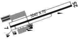
| Runways: | 07/25 |
| Longest Runway: | 07/25 is 3040 ft (927 m) long |
| Runways with an Instrument Approach: |
4S2 Airport Runway Details
| Runway 07/25 | 3040 ft x 75 ft (927 m x 23 m) | |
| Surface: | Asphalt - Excellent condition - No special surface treatment | |
| Runway Edge Lights: | Medium Intensity | |
Runway Weight Bearing Capacity (in thousands of pounds) |
||
| Single Wheel Landing Gear: | 23.0 | |
Runway 07 |
Runway 25 |
|
Elevation: |
631.1 | 597.3 |
Latitude: |
45-40-21.9885N | 45-40-22.0042N |
Longitude: |
121-32-23.3432W | 121-31-40.4765W |
|
Runway True Alignment: |
090 | 270 |
Glide Path Angle: |
0.0 degrees | 0.0 degrees |
Traffic Pattern: |
Left | Left |
Runway Markings Type: |
Basic | Basic |
Runway Markings Condition: |
Good | Good |
Object at End: |
TREE | TREE |
Object Height: |
93 | 50 |
Distance from End: |
1460 | 980 |
Object Centerline Offset: |
210 ft. right of centerline | 140 ft. right of centerline |
REIL: |
Yes |
Services
Airframe Repair: |
Major |
Powerplant Repair: |
Major |
Bottled Oxygen: |
None |
Bulk Oxygen: |
High Pressure |
Fuel Available: |
100LL, Jet A |
Landing Fees: |
No |
Parking: |
Tiedowns available |
Maps & Diagrams
4S2 Sectional
Flight Planning
at skyvector.com
at skyvector.com