Location
Latitude: |
41-19-07.2487N (41.31868) |
Longitude: |
081-57-37.5906W (-81.960442) |
Elevation: |
810.7 feet MSL (247 m MSL) |
Magnetic Variation: |
8.1 W (as of April 2024 from WMM2020 model) |
Time Zone: |
UTC -5.0 (Standard Time) UTC -4.0 (Daylight Savings Time) |
From City: |
01 N.M. NW of Columbia Station, Ohio |
Found On: |
Detroit Chart |
FAA Region: |
AGL |
Contacts
Manager: |
Privately owned: |
| DAVID SAVILLE PO BOX 599 COLUMBIA STATION, OH 44028-0599 757-510-6788 |
COLUMBIA ENTERPRISES, INC 27410 ROYALTON RD COLUMBIA STATION, OH 44028-9159 440-236-8800 |
Operations
Airport Status: |
Operational |
Facility Use: |
Public |
Type: |
Airport |
Activation Date: |
09/1955 |
Control tower: |
No |
Attendance (Months/Days/Hours): |
Months/Days/Hours ALL/ALL/IREG |
Boundary ARTCC: |
ZOB (Cleveland) |
Responsible ARTCC: |
ZOB (Cleveland) |
Lighting Schedule: |
SEE RMK |
Segmented Circle Indicator: |
No |
Traffic Pattern Altitude (MSL): |
1811 feet (552 m) |
NOTAMs Facility: |
CLE |
NOTAM-D Service: |
Yes |
International Airport of Entry: |
No |
Customs Landing Rights: |
No |
Based Aircraft
| Single Engine: | 33 |
Annual Operations (as of 10/04/2022)
| Total Operations: | 5050 | |
| GA Local: | 2400 | 47.5% |
| GA Itinerant: | 2650 | 52.5% |
Communications
| CTAF: | 122.800 |
| Unicom: | 122.800 |
Fixed Based Operators (FBOs) & Fuel
(Click on a business for detail)
Please help us keep this information up to date. This is a FREE SERVICE just like everything else on Airport Guide! If you see that a business needs to be added, modified, or deleted please fill out our Update Form.
To add, modify, or delete a business click here.
Please help us keep this information up to date. This is a FREE SERVICE just like everything else on Airport Guide! If you see that a business needs to be added, modified, or deleted please fill out our Update Form.
Area Code: 440 |
| Business Name | Frequency | Phone | Fuel Grade |
|---|---|---|---|
| Columbia Airport
Update FBO info |
236 8800 |
Flight Service Stations
| Primary | Alternate | |
| FSS on Field: | N | |
| FSS Name (ID): | Cleveland(CLE) | |
| Frequency: | ||
| Toll Free Phone: | 1-800-WX-BRIEF |
Instrument Procedures / Charts
Terminal Procedures are only available for airports in several countries with more being added all the time. If you are looking for a specific country's charts, please send an email to support(at)airportguide.com stating the country name. This will be used to prioritize the implementation.
Navigation Aids (Navaids) near 4G8
| Dist (NM) | ID | Morse Code | Name | Type | Freq | True Hdg | Mag Hdg |
|---|---|---|---|---|---|---|---|
| 7.8 | CLE | _ . _ . . _ . . . | Cleveland | VOT | 110.40 | 39 | 47 |
| 9.4 | DJB | _ . . . _ _ _ _ . . . | Dryer | VOR-DME | 113.60 | 284 | 292 |
| 25.1 | AAU | . _ . _ . . _ | Ashland | NDB | 329 | 211 | 219 |
| 29.9 | AK | . _ _ . _ | Akron | NDB | 362 | 119 | 127 |
| 32.0 | SKY | . . . _ . _ _ . _ _ | Sandusky | VOR-DME | 109.20 | 282 | 290 |
| 33.6 | CAK | _ . _ . . _ _ . _ | Akron/Canton Regional | VOT | 110.60 | 135 | 143 |
| 34.0 | LQL | . _ . . _ _ . _ . _ . . | Lakeland | NDB | 263 | 49 | 57 |
| 36.5 | ACO | . _ _ . _ . _ _ _ | Akron | VOR-DME | 114.40 | 110 | 118 |
| 37.8 | CXR | _ . _ . _ . . _ . _ . | Chardon | VOR-DME | 112.70 | 71 | 79 |
| 39.3 | MFD | _ _ . . _ . _ . . | Mansfield | VORTAC | 108.80 | 226 | 234 |
| 39.7 | MF | _ _ . . _ . | Manns | NDB | 372 | 213 | 221 |
| 42.1 | BSV | _ . . . . . . . . . _ | Briggs | VOR-DME | 112.40 | 145 | 153 |
| 42.6 | PCW | . _ _ . _ . _ . . _ _ | Port Clinton | NDB | 423 | 286 | 294 |
| 46.8 | MLR | _ _ . _ . . . _ . | Millersburg/Dcmsnd | NDB | 382 | 175 | 183 |
| 57.9 | YNG | _ . _ _ _ . _ _ . | Youngstown | VORTAC | 109.00 | 88 | 97 |
| 58.2 | TII | _ . . . . | Tiffin | NDB | 269 | 257 | 265 |
| 59.8 | 4L | Chatham | NDB | 236 | 355 | 363 | |
| 60.5 | JFN | . _ _ _ . . _ . _ . | Jefferson | DME | 115.2 | 63 | 72 |
| 61.9 | YN | _ . _ _ _ . | Fetch | NDB | 338 | 96 | 105 |
| 65.2 | HBD | . . . . _ . . . _ . . | Hubbard | NDB | 408 | 98 | 107 |
Nearby Airports with Fuel
Notices to Airmen (NOTAMS)
Remarks
| A110*G | THIS AIRPORT HAS BEEN SURVEYED BY THE NATIONAL GEODETIC SURVEY. |
| A110-2 | FOR CD CTC CLEVELAND APCH AT 216-352-2323. |
| A14 | 4G8COLUMBIAAIRPORT@GMAIL.COM. |
| A30-18/36 | CLSD DLY SS-SR. |
| A30A-36 | CALM WIND RWY. |
| A40-18/36 | NSTD LIRL DUE TO MISG THR LGTS. |
| A42-18 | NSTD NRS ONLY DUE TO NO DTHR MKGS, NO ARROWHEADS; NORTH 300 FT UNMKD. |
| A42-36 | NSTD NRS ONLY DUE TO NO DTHR MKGS, NO ARROWHEADS; NORTH 300 FT UNMKD. |
| A57-18 | OBSTN CLNC SLP 14:1 TO DTHR. |
| A57-36 | OBSTN CLNC SLP 11:1 TO DTHR. |
| A58-18 | 35 FT TREES, 0 FT DIST, 130 FT B. |
| A75 | PRIOR CDN RQRD. |
| A81-APT | NSTD LIRL RWY 18/36 OTS INDEFLY. |
| E111 | ESTABD BFR 1959. |
Runways
Runway Summary
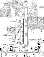
| Runways: | 18/36 |
| Longest Runway: | 18/36 is 3152 ft (961 m) long |
| Runways with an Instrument Approach: |
4G8 Airport Runway Details
| Runway 18/36 | 3152 ft x 40 ft (961 m x 12 m) | |
| Runway Length Source: | NGS as of 12/04/2001 | |
| Surface: | Asphalt - Fair condition - No special surface treatment | |
| Runway Edge Lights: | Non-standard lighting system Intensity | |
Runway 18 |
Runway 36 |
|
Elevation: |
809.5 | 810.1 |
Latitude: |
41-19-22.8168N | 41-18-51.6806N |
Longitude: |
081-57-37.1477W | 081-57-38.0335W |
|
Runway True Alignment: |
181 | 001 |
Glide Path Angle: |
0.0 degrees | 0.0 degrees |
Traffic Pattern: |
Left | Left |
Runway Markings Type: |
Nonstandard (other than numbers only) | Nonstandard (other than numbers only) |
Runway Markings Condition: |
Fair | Fair |
Object at End: |
TREES | TREE |
Object Height: |
35 | 60 |
Distance from End: |
201 | 450 |
Object Centerline Offset: |
130 ft. left and right of centerline | 25 ft. right of centerline |
Threshold Elevation: |
809.5 | 810.7 |
Displaced Threshold: |
300 | 209 |
Threshold Latitude: |
41-19-19.8535N | 41-18-53.7447N |
Threshold Longitude: |
081-57-37.2320W | 081-57-37.9748W |
Services
Airframe Repair: |
Major |
Powerplant Repair: |
Major |
Bottled Oxygen: |
High Pressure |
Bulk Oxygen: |
None |
Fuel Available: |
100LL, Jet A+ |
Landing Fees: |
No |
Parking: |
Hangars and tiedowns available |
Maps & Diagrams
4G8 Sectional
Flight Planning
at skyvector.com
at skyvector.com